File:خريطة عثمانية للدولة التيمورية وللأناضول.jpg

Size of this preview: 800 × 490 pixels. Other resolutions: 320 × 196 pixels | 640 × 392 pixels | 1,224 × 750 pixels.
Original file (1,224 × 750 pixels, file size: 524 KB, MIME type: image/jpeg)
Captions
Captions
Add a one-line explanation of what this file represents
Summary edit
| Description |
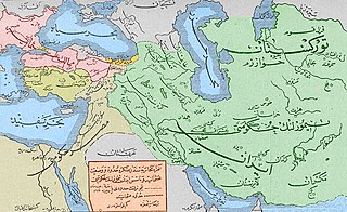
العربية: خريطة بِالتُركيَّة العُثمانيَّة تُظهر حُدود الدولة التيموريَّة والإمارات التُركمانيَّة الأناضوليَّة التي أعاد تيمورلنك إحيائها بعد هزيمة العُثمانيين في معركة أنقرة.
English: Map in Ottoman Turkish showing the boarders of the Timurid Empire and the Anatolian Turkmen beyliks Tamerlane Recreated after the ottoman defeat at the battle of Ankara. |
| Date | |
| Source | Taken from an Ottoman book entitled "عثمانلى تاريخى" vol. I, 1st printed in Istanbul in 1911 approx. Check AUB Records |
| Author | unknown. book writer was Namik Kamal. |
Licensing edit
This work first published in the Ottoman Empire is now in the public domain because the Empire's copyright formalities were not met (copyright notice, registration, and deposit), or because the copyright term (30 years after the death of the author, sometimes less) expired before the Empire was dissolved (details).
|
.svg) |
File history
Click on a date/time to view the file as it appeared at that time.
| Date/Time | Thumbnail | Dimensions | User | Comment | |
|---|---|---|---|---|---|
| current | 11:30, 3 October 2017 | | 1,224 × 750 (524 KB) | باسم (talk | contribs) | self colored - لُوَّنتها بنفسي |
| 20:36, 8 August 2017 |  | 1,224 × 750 (513 KB) | باسم (talk | contribs) | User created page with UploadWizard |
You cannot overwrite this file.
File usage on Commons
There are no pages that use this file.
File usage on other wikis
The following other wikis use this file:
- Usage on ar.wikipedia.org