File:نقشه بخش آبپخش و موقعیت شهر آبپخش.png

Size of this preview: 800 × 420 pixels. Other resolutions: 320 × 168 pixels | 888 × 466 pixels.
Original file (888 × 466 pixels, file size: 72 KB, MIME type: image/png)
Captions
Captions
Add a one-line explanation of what this file represents
Summary
edit
| Description |
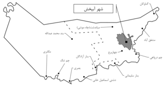
فارسی: این نقشه تقسیمات کشوری بخش آبپخش می باشد. در این نقشه دهستان دشتی اسماعیل خانی و دهستان درواهی نشان داده شده است. همچنین موقعیت و اندازه شهر آبپخش به رنگ خاکستری در این بخش نسان داده شده است. این اثر شخصی است و توسط خود آپلود کننده طراحی و ساخته شده است. نقشه براساس داده های اداره آمار در سال 1395 رسم شده است. |
| Date | |
| Source | Own work |
| Author | Rohalamin |
Licensing
edit
I, the copyright holder of this work, hereby publish it under the following license:
This file is licensed under the Creative Commons Attribution-Share Alike 4.0 International license.
- You are free:
- to share – to copy, distribute and transmit the work
- to remix – to adapt the work
- Under the following conditions:
- attribution – You must give appropriate credit, provide a link to the license, and indicate if changes were made. You may do so in any reasonable manner, but not in any way that suggests the licensor endorses you or your use.
- share alike – If you remix, transform, or build upon the material, you must distribute your contributions under the same or compatible license as the original.
File history
Click on a date/time to view the file as it appeared at that time.
| Date/Time | Thumbnail | Dimensions | User | Comment | |
|---|---|---|---|---|---|
| current | 12:28, 30 April 2021 | | 888 × 466 (72 KB) | Rohalamin (talk | contribs) | Uploaded own work with UploadWizard |
You cannot overwrite this file.
File usage on Commons
The following 39 pages use this file:
- Category:Ab Pakhsh
- Category:Air transport in Ab Pakhsh
- Category:Architecture of Ab Pakhsh
- Category:Art of Ab Pakhsh
- Category:Automobiles in Ab Pakhsh
- Category:Bridges in Ab Pakhsh
- Category:Buildings in Ab Pakhsh
- Category:Cultural buildings in Ab Pakhsh
- Category:Culture of Ab Pakhsh
- Category:Economy of Ab Pakhsh
- Category:Education in Ab Pakhsh
- Category:Flora of Ab Pakhsh
- Category:Food in Ab Pakhsh
- Category:Geography of Ab Pakhsh
- Category:Government buildings in Ab Pakhsh
- Category:History of Ab Pakhsh
- Category:Infrastructure in Ab Pakhsh
- Category:Land transport in Ab Pakhsh
- Category:Landscape architecture in Ab Pakhsh
- Category:Libraries in Ab Pakhsh
- Category:Maps of Ab Pakhsh
- Category:Motor vehicles in Ab Pakhsh
- Category:Motorcycles in Ab Pakhsh
- Category:Nature of Ab Pakhsh
- Category:People of Ab Pakhsh
- Category:Politics of Ab Pakhsh
- Category:Road transport in Ab Pakhsh
- Category:Road transport infrastructure in Ab Pakhsh
- Category:Road vehicles in Ab Pakhsh
- Category:Schools in Ab Pakhsh
- Category:Society of Ab Pakhsh
- Category:Squares in Ab Pakhsh
- Category:Storage buildings in Ab Pakhsh
- Category:Streets in Ab Pakhsh
- Category:Transport in Ab Pakhsh
- Category:Transport infrastructure in Ab Pakhsh
- Category:Trees in Ab Pakhsh
- Category:Vehicles in Ab Pakhsh
- Category:Views of Ab Pakhsh
File usage on other wikis
The following other wikis use this file:
- Usage on arz.wikipedia.org
- Usage on fa.wikipedia.org
- Usage on www.wikidata.org