File:แผนที่แสดงสถานีของระบบรถไฟฟ้ามหานคร(กรุงเทพฯ)สายสีเขียวอ่อน.svg

Size of this PNG preview of this SVG file: 120 × 600 pixels. Other resolutions: 48 × 240 pixels | 96 × 480 pixels | 153 × 768 pixels | 204 × 1,024 pixels | 409 × 2,048 pixels | 400 × 2,000 pixels.
Original file (SVG file, nominally 400 × 2,000 pixels, file size: 1.28 MB)
Captions
Captions
Add a one-line explanation of what this file represents
Summary edit
%E0%B8%AA%E0%B8%B2%E0%B8%A2%E0%B8%AA%E0%B8%B5%E0%B9%80%E0%B8%82%E0%B8%B5%E0%B8%A2%E0%B8%A7%E0%B8%AD%E0%B9%88%E0%B8%AD%E0%B8%99.svg&action=edit§ion=1)
| Description |
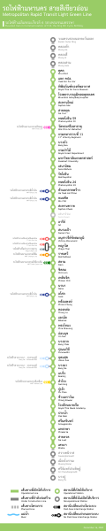
ไทย: แผนที่แสดงสถานีของระบบรถไฟฟ้ามหานคร(กรุงเทพฯ)สายสีเขียวอ่อน
English: Map showing the stations of the MRT (Bangkok) Green Line. |
| Date | |
| Source | Own work |
| Author | Virakri |
Licensing edit
%E0%B8%AA%E0%B8%B2%E0%B8%A2%E0%B8%AA%E0%B8%B5%E0%B9%80%E0%B8%82%E0%B8%B5%E0%B8%A2%E0%B8%A7%E0%B8%AD%E0%B9%88%E0%B8%AD%E0%B8%99.svg&action=edit§ion=2)
I, the copyright holder of this work, hereby publish it under the following license:
This file is licensed under the Creative Commons Attribution-Share Alike 3.0 Unported license.
- You are free:
- to share – to copy, distribute and transmit the work
- to remix – to adapt the work
- Under the following conditions:
- attribution – You must give appropriate credit, provide a link to the license, and indicate if changes were made. You may do so in any reasonable manner, but not in any way that suggests the licensor endorses you or your use.
- share alike – If you remix, transform, or build upon the material, you must distribute your contributions under the same or compatible license as the original.
File history
Click on a date/time to view the file as it appeared at that time.
| Date/Time | Thumbnail | Dimensions | User | Comment | |
|---|---|---|---|---|---|
| current | 10:41, 23 November 2021 | 400 × 2,000 (1.28 MB) | Oum13928 (talk | contribs) | ปรับปรุงใหม่ | |
| 10:13, 22 December 2020 | 400 × 2,000 (1.3 MB) | Oum13928 (talk | contribs) | เพิ่มสถานีใหม่ | ||
| 15:45, 7 June 2020 | 400 × 2,000 (1.29 MB) | Oum13928 (talk | contribs) | ปรับปรุงใหม่ | ||
| 09:08, 7 June 2020 | 400 × 2,000 (1.27 MB) | Oum13928 (talk | contribs) | เพิ่มสถานีเปิดใหม่ และแก้ไขเล้กน้อย | ||
| 05:16, 3 January 2012 | 400 × 2,000 (1.29 MB) | Virakri (talk | contribs) |
You cannot overwrite this file.
File usage on Commons
The following 7 pages use this file:
- User:Chumwa/OgreBot/Public transport information/2020 December 21-31
- User:Chumwa/OgreBot/Public transport information/2020 June 1-10
- User:Chumwa/OgreBot/Public transport information/2021 November 21-30
- User:Chumwa/OgreBot/Transport Maps/2020 December 21-31
- User:Chumwa/OgreBot/Transport Maps/2020 June 1-10
- User:Chumwa/OgreBot/Transport Maps/2021 November 21-30
- File:แผนที่แสดงสถานีของระบบรถไฟฟ้ามหานคร(กรุงเทพฯ)สายสีเขียวอ่อน.svg.svg (file redirect)
%E0%B8%AA%E0%B8%B2%E0%B8%A2%E0%B8%AA%E0%B8%B5%E0%B9%80%E0%B8%82%E0%B8%B5%E0%B8%A2%E0%B8%A7%E0%B8%AD%E0%B9%88%E0%B8%AD%E0%B8%99.svg.svg&redirect=no)
File usage on other wikis
The following other wikis use this file:
- Usage on th.wikipedia.org
สายสีเขียวอ่อน.svg&oldid=730867665)