File:トリトン画像(国土地理院).png

Size of this preview: 800 × 236 pixels. Other resolutions: 320 × 94 pixels | 640 × 189 pixels | 1,024 × 302 pixels | 1,280 × 377 pixels | 4,775 × 1,408 pixels.
Original file (4,775 × 1,408 pixels, file size: 9.67 MB, MIME type: image/png)
Captions
Captions
Add a one-line explanation of what this file represents
Summary edit
| Description |
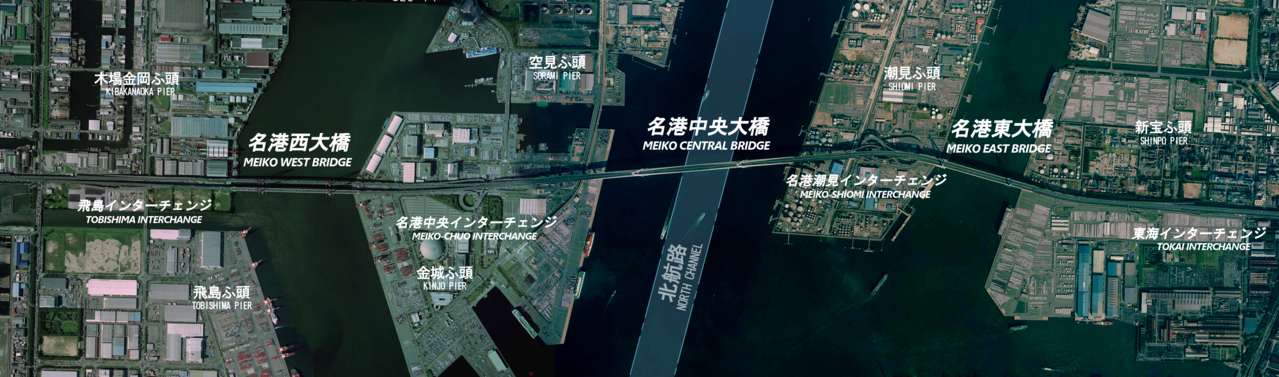
日本語: 名港トリトン3橋。ふ頭名称、英語表記(名港中央大橋:MEIKO CENTRAL BRIDGE など)は「名古屋港要覧2016」(名古屋港管理組合発行)に準拠。 |
| Date | |
| Source | 国土画像情報(カラー空中写真)(CCB20072-C29-74とCCB200441X-C7-26との合成画像) |
| Author | 国土地理院 |
Licensing edit

|
The copyright holder of this file, the Ministry of Land, Infrastructure, Transport and Tourism of Japan, allows anyone to use it for any purpose, provided that the copyright holder is properly attributed. Redistribution, derivative work, commercial use, and all other use is permitted. |
Attribution:
Copyright © National Land Image Information (Color Aerial Photographs), Ministry of Land, Infrastructure, Transport and Tourism
|
 |
This image is copyrighted by the Ministry of Land, Infrastructure, Transport and Tourism of Japan. For terms of use, see the stipulation to use of National Land Information (in Japanese) and message from MLIT (in Japanese and English). When you display this image on an article, include the following phrase in the description: "Made based on National Land Image Information (Color Aerial Photographs), Ministry of Land, Infrastructure, Transport and Tourism".
|
File history
Click on a date/time to view the file as it appeared at that time.
| Date/Time | Thumbnail | Dimensions | User | Comment | |
|---|---|---|---|---|---|
| current | 14:18, 4 November 2017 | 4,775 × 1,408 (9.67 MB) | Oka21000 (talk | contribs) | フェリーふ頭削除、北航路追加 | |
| 12:49, 20 June 2017 | 4,775 × 1,408 (9.61 MB) | Oka21000 (talk | contribs) | ふ頭名称、インターチェンジ名称追加。画像も拡大。 | ||
| 05:22, 18 June 2017 | 4,104 × 1,408 (7.99 MB) | Oka21000 (talk | contribs) | {{Information |Description ={{ja|1=名港トリトン3橋}} |Source =国土画像情報(カラー空中写真)(CCB20072-C29-74とCCB200441X-C7-26との合成画像) |Author =国土地理院 |Date =2007-09-18 |Permis... |
You cannot overwrite this file.
File usage on Commons
The following 3 pages use this file:
File usage on other wikis
The following other wikis use this file:
- Usage on ja.wikipedia.org
.png&oldid=743181464)