File:영월지질.jpg

Size of this preview: 800 × 466 pixels. Other resolutions: 320 × 186 pixels | 640 × 373 pixels | 1,024 × 596 pixels | 1,280 × 745 pixels | 1,876 × 1,092 pixels.
Original file (1,876 × 1,092 pixels, file size: 1.05 MB, MIME type: image/jpeg)
Captions
Captions
Add a one-line explanation of what this file represents
Summary edit
| Description |
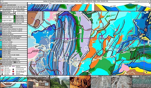
English: Geology structure of Yeongwol Thrust System in Yeongwol county, Gangwon Province, South Korea reference * Geological map of Korea Institute of Geoscience and Mineral Resources (공공누리 제2 유형) * Geological Structures of Yeongweol - Yemi Area, Kangweon-do, Korea (1991) * Sedimentological, Stratigraphical and Paleontological Study on the Sambangsan Formation and Its Adjacent Formations in the Yeongweol-Pyeongchang Area, Kangweondo (1986) * Geological Structures of the Yemi Area, Kangweon-do, Korea (1991) |
| Date | |
| Source | Own work |
| Author | Dittwjfsdgkvkdjg |
Licensing edit
I, the copyright holder of this work, hereby publish it under the following license:
This file is licensed under the Creative Commons Attribution-Share Alike 3.0 Unported license.
- You are free:
- to share – to copy, distribute and transmit the work
- to remix – to adapt the work
- Under the following conditions:
- attribution – You must give appropriate credit, provide a link to the license, and indicate if changes were made. You may do so in any reasonable manner, but not in any way that suggests the licensor endorses you or your use.
- share alike – If you remix, transform, or build upon the material, you must distribute your contributions under the same or compatible license as the original.
This file is uploaded through the Korean Wikipedia, which has not been reviewed on Commons.
|
File history
Click on a date/time to view the file as it appeared at that time.
| Date/Time | Thumbnail | Dimensions | User | Comment | |
|---|---|---|---|---|---|
| current | 09:51, 12 April 2024 | | 1,876 × 1,092 (1.05 MB) | Dittwjfsdgkvkdjg (talk | contribs) | 수정 |
| 05:39, 18 June 2023 |  | 1,876 × 908 (1.42 MB) | Dittwjfsdgkvkdjg (talk | contribs) | 수정 | |
| 05:54, 17 June 2023 |  | 1,876 × 908 (1.39 MB) | Dittwjfsdgkvkdjg (talk | contribs) | 지질단면 | |
| 03:33, 29 January 2023 |  | 1,876 × 908 (838 KB) | Dittwjfsdgkvkdjg (talk | contribs) | 트러스트→스러스트로 변경 | |
| 01:41, 18 November 2022 |  | 1,876 × 908 (1.32 MB) | Dittwjfsdgkvkdjg (talk | contribs) | 고성 셰일/석회암층 설명 추가 | |
| 13:34, 25 October 2022 |  | 1,876 × 908 (1.3 MB) | Dittwjfsdgkvkdjg (talk | contribs) | 설론, 고성, 신동 트러스트 단층 | |
| 10:57, 25 October 2022 |  | 1,876 × 908 (1.29 MB) | Dittwjfsdgkvkdjg (talk | contribs) | 단곡 단층, ESR 연대측정값 | |
| 08:28, 21 October 2022 |  | 1,876 × 908 (757 KB) | Dittwjfsdgkvkdjg (talk | contribs) | 방림 트러스트 단층 기입, 설명 추가 | |
| 09:43, 16 October 2022 |  | 1,876 × 908 (1.24 MB) | Dittwjfsdgkvkdjg (talk | contribs) | Uploaded own work with UploadWizard |
You cannot overwrite this file.
File usage on Commons
The following 6 pages use this file:
File usage on other wikis
The following other wikis use this file:
- Usage on en.wikipedia.org
- Usage on ko.wikipedia.org
- 울릉도
- 공주시
- 한라산
- 수원시
- 강릉시
- 상주시
- 충주시
- 마이산
- 이천시
- 태백시
- 삼척시
- 영월군
- 정선군
- 철원군 (남)
- 설악산
- 상주 운평리 구상화강암
- 성류굴
- 삼척 대이리 동굴지대
- 의령 서동리 함안층 빗방울 자국
- 영월 고씨굴
- 함안 용산리 함안층 새발자국화석 산지
- 밀양 남명리 얼음골
- 삼척 초당굴
- 단양 고수동굴
- 평창 백룡동굴
- 단양 온달동굴
- 단양 노동동굴
- 부산 전포동 구상반려암
- 의성 제오리 공룡발자국화석 산지
- 진주 유수리 백악기 화석 산지
- 해남 우항리 공룡·익룡·새발자국화석 산지
- 진주 가진리 새발자국과 공룡발자국화석 산지
- 고성 덕명리 공룡과 새발자국 화석산지
- 영월 문곡리 건열구조 및 스트로마톨라이트
- 화성 고정리 공룡알화석 산지
- 포항 달전리 주상절리
- 태백 장성 전기고생대 화석 산지
- 구문소
- 성산일출봉
- 여수 낭도리 공룡발자국화석 산지 및 퇴적층
- 달성 비슬산 암괴류
- 한탄강 대교천 현무암 협곡
- 강릉 정동진 해안단구
- 부안군
- 봉화군
- 익산시
- 포항시
- 고창군
- 영주시
View more global usage of this file.