File:(Plan de New-York et les environs. LOC gm71000992.jpg

Size of this preview: 771 × 600 pixels. Other resolutions: 309 × 240 pixels | 617 × 480 pixels | 988 × 768 pixels | 1,280 × 995 pixels | 2,560 × 1,991 pixels | 6,419 × 4,992 pixels.
Original file (6,419 × 4,992 pixels, file size: 4.03 MB, MIME type: image/jpeg)
Captions
Captions
Add a one-line explanation of what this file represents
Summary edit
| Description |
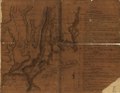
English: Scale ca. 1:82,000. Manuscript, pen-and-ink and watercolor. Relief shown by hachures. "Legende" indicates earthworks, forts, etc. with indication of number of soldiers to man them. LC Maps of North America, 1750-1789, 1214 Available also through the Library of Congress Web site as a raster image. Vault AACR2: 440; 651/1; 650/2; 651/3 |
||
| Title | [Plan de New-York et les environs. | ||
| Shelf ID | G3804.N4 1781 .P51 | ||
| Date | |||
| Source | https://www.loc.gov/item/gm71000992/ | ||
| Author | Unknown author | ||
| Permission (Reusing this file) |
|
||
| Other versions |
|
||
| Location | United States · New York City · New York · New York (State) | ||
| Part of | France In America · Rochambeau Map Collection · Military Battles And Campaigns · Catalog · American Memory · Geography And Map Division · American Revolution And Its Era: Maps And Charts Of North America And The West Indies, 1750-1789 | ||
| Subject | Maps, Manuscript · Buildings, Structures, Etc · Fortification · New York (N.Y.) · United States · Maps · Early Works To 1800 · New York · New York (State) |

Licensing edit
|
This is a faithful photographic reproduction of a two-dimensional, public domain work of art. The work of art itself is in the public domain for the following reason:
The official position taken by the Wikimedia Foundation is that "faithful reproductions of two-dimensional public domain works of art are public domain".
This photographic reproduction is therefore also considered to be in the public domain in the United States. In other jurisdictions, re-use of this content may be restricted; see Reuse of PD-Art photographs for details. | ||||
File history
Click on a date/time to view the file as it appeared at that time.
| Date/Time | Thumbnail | Dimensions | User | Comment | |
|---|---|---|---|---|---|
| current | 21:00, 5 June 2018 | | 6,419 × 4,992 (4.03 MB) | Fæ (talk | contribs) | LOC Maps https://www.loc.gov/item/gm71000992/ #21149 |
You cannot overwrite this file.
File usage on Commons
The following page uses this file: