File:126-255 Auburn Avenue (Commercial Buildings), Auburn Avenue, Atlanta, Fulton County, GA HABS GA,61-ATLA,1C- (sheet 17 of 18).tif

Size of this JPG preview of this TIF file: 800 × 531 pixels. Other resolutions: 320 × 213 pixels | 640 × 425 pixels | 1,024 × 680 pixels | 1,280 × 850 pixels | 2,560 × 1,701 pixels | 14,500 × 9,632 pixels.
Original file (14,500 × 9,632 pixels, file size: 2.23 MB, MIME type: image/tiff)
Captions
Captions
Add a one-line explanation of what this file represents
Summary edit
| Warning | The original file is very high-resolution. It might not load properly or could cause your browser to freeze when opened at full size. |
|---|
| HABS GA,61-ATLA,1C- (sheet 17 of 18) - 126-255 Auburn Avenue (Commercial Buildings), Auburn Avenue, Atlanta, Fulton County, GA | ||||
|---|---|---|---|---|
| Title |
HABS GA,61-ATLA,1C- (sheet 17 of 18) - 126-255 Auburn Avenue (Commercial Buildings), Auburn Avenue, Atlanta, Fulton County, GA |
|||
| Depicted place | Georgia; Fulton County; Atlanta | |||
| Date | Documentation compiled after 1933 | |||
| Dimensions | 24 x 36 in. (D size) | |||
| Current location |
Library of Congress Prints and Photographs Division Washington, D.C. 20540 USA http://hdl.loc.gov/loc.pnp/pp.print |
|||
| Accession number |
HABS GA,61-ATLA,1C- (sheet 17 of 18) |
|||
| Credit line |
|
|||
| Notes |
|
|||
| References |
|
|||
| Source | https://www.loc.gov/pictures/item/ga0211.sheet.00017a | |||
| Permission (Reusing this file) |
|
|||
| Other versions |
,_Auburn_Avenue,_Atlanta,_Fulton_County,_GA_HABS_GA,61-ATLA,1C-_(sheet_1_of_18).png) ,_Auburn_Avenue,_Atlanta,_Fulton_County,_GA_HABS_GA,61-ATLA,1C-_(sheet_10_of_18).png) ,_Auburn_Avenue,_Atlanta,_Fulton_County,_GA_HABS_GA,61-ATLA,1C-_(sheet_11_of_18).png) ,_Auburn_Avenue,_Atlanta,_Fulton_County,_GA_HABS_GA,61-ATLA,1C-_(sheet_12_of_18).png) ,_Auburn_Avenue,_Atlanta,_Fulton_County,_GA_HABS_GA,61-ATLA,1C-_(sheet_13_of_18).png) ,_Auburn_Avenue,_Atlanta,_Fulton_County,_GA_HABS_GA,61-ATLA,1C-_(sheet_14_of_18).png) ,_Auburn_Avenue,_Atlanta,_Fulton_County,_GA_HABS_GA,61-ATLA,1C-_(sheet_15_of_18).png) ,_Auburn_Avenue,_Atlanta,_Fulton_County,_GA_HABS_GA,61-ATLA,1C-_(sheet_16_of_18).png) ,_Auburn_Avenue,_Atlanta,_Fulton_County,_GA_HABS_GA,61-ATLA,1C-_(sheet_17_of_18).png) ,_Auburn_Avenue,_Atlanta,_Fulton_County,_GA_HABS_GA,61-ATLA,1C-_(sheet_18_of_18).png) ,_Auburn_Avenue,_Atlanta,_Fulton_County,_GA_HABS_GA,61-ATLA,1C-_(sheet_2_of_18).png) ,_Auburn_Avenue,_Atlanta,_Fulton_County,_GA_HABS_GA,61-ATLA,1C-_(sheet_3_of_18).png) ,_Auburn_Avenue,_Atlanta,_Fulton_County,_GA_HABS_GA,61-ATLA,1C-_(sheet_4_of_18).png) ,_Auburn_Avenue,_Atlanta,_Fulton_County,_GA_HABS_GA,61-ATLA,1C-_(sheet_5_of_18).png) ,_Auburn_Avenue,_Atlanta,_Fulton_County,_GA_HABS_GA,61-ATLA,1C-_(sheet_6_of_18).png) ,_Auburn_Avenue,_Atlanta,_Fulton_County,_GA_HABS_GA,61-ATLA,1C-_(sheet_7_of_18).png) ,_Auburn_Avenue,_Atlanta,_Fulton_County,_GA_HABS_GA,61-ATLA,1C-_(sheet_8_of_18).png) ,_Auburn_Avenue,_Atlanta,_Fulton_County,_GA_HABS_GA,61-ATLA,1C-_(sheet_9_of_18).png) |
|||

| Object location | | View this and other nearby images on: OpenStreetMap |
|---|
File history
Click on a date/time to view the file as it appeared at that time.
| Date/Time | Thumbnail | Dimensions | User | Comment | |
|---|---|---|---|---|---|
| current | 20:30, 13 July 2014 | 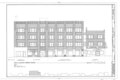 | 14,500 × 9,632 (2.23 MB) | Fæ (talk | contribs) | GWToolset: Creating mediafile for Fæ. HABS 09 July 2014 (801:1000) |
You cannot overwrite this file.
File usage on Commons
The following 2 pages use this file: