File:15thcenturyhispaniola v2.JPG

Size of this preview: 800 × 531 pixels. Other resolutions: 320 × 212 pixels | 640 × 425 pixels | 1,024 × 680 pixels | 1,280 × 850 pixels | 2,560 × 1,699 pixels | 3,343 × 2,219 pixels.
Original file (3,343 × 2,219 pixels, file size: 4.4 MB, MIME type: image/jpeg)
Captions
Captions
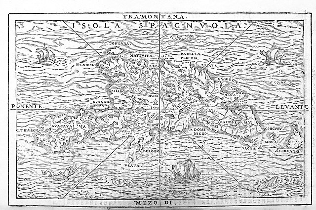
Island of Hispaniola (1606)
Summary edit
| Description |
English: Italian map of Hispaniola. Español: Mapa italiano de La Española (siglo XVII) |
| Date | |
| Source |
Self-scanned From volume 3 of Delle navigationi et viaggi, a collection of first-hand accounts of exploration, published in Venice |
| Author |
Giovanni Battista Ramusio Original uploaders: Electionworld & DO'Neil (modifications: Suaheli) |
| Other versions | Image:15thcenturyhispaniola.JPG |
Licensing edit
|
This work is in the public domain in its country of origin and other countries and areas where the copyright term is the author's life plus 100 years or fewer. This work is in the public domain in the United States because it was published (or registered with the U.S. Copyright Office) before January 1, 1929. | |
| This file has been identified as being free of known restrictions under copyright law, including all related and neighboring rights. | |
File history
Click on a date/time to view the file as it appeared at that time.
| Date/Time | Thumbnail | Dimensions | User | Comment | |
|---|---|---|---|---|---|
| current | 20:36, 12 December 2020 | | 3,343 × 2,219 (4.4 MB) | Indies1 (talk | contribs) | Higher resolution image of same map. |
| 18:31, 15 July 2008 |  | 1,200 × 794 (304 KB) | Suaheli~commonswiki (talk | contribs) | {{Information |Description=15th century map of Hispaniola. |Source=Scan |Date=? |Author=Original uploaders: Electionworld & DO'Neil (modifications: Suaheli) |Permission= |other_versions=Image:15thcenturyhispaniola.JPG }} {{ImageUploa |
You cannot overwrite this file.
File usage on Commons
The following page uses this file:
File usage on other wikis
The following other wikis use this file:
- Usage on ca.wikipedia.org
- Usage on de.wikipedia.org
- Usage on es.wikipedia.org
- Usage on fr.wikipedia.org