File:1728 Homann Map of Bavaria, Germany - Geographicus - Bavariae-homann-1728.jpg

Size of this preview: 516 × 600 pixels. Other resolutions: 206 × 240 pixels | 413 × 480 pixels | 661 × 768 pixels | 881 × 1,024 pixels | 1,762 × 2,048 pixels | 4,301 × 5,000 pixels.
Original file (4,301 × 5,000 pixels, file size: 8.6 MB, MIME type: image/jpeg)
Captions
Captions
Add a one-line explanation of what this file represents
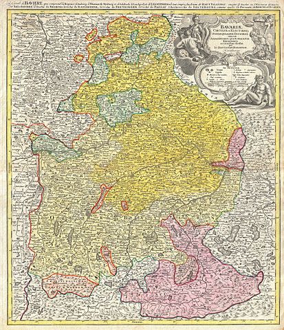
| Johann Homann: Bavariae Circulus et Electorat Insuadquasque Ditiones tam cum Adiacentibus Quam Insertis Regionibus accuratissime divisus part Jo: Baptistam Homannum Norimbergae. - La cercle de Baviere, qui comprend la regence d'Amberg …
( |
||||||||||||||||||||||||
|---|---|---|---|---|---|---|---|---|---|---|---|---|---|---|---|---|---|---|---|---|---|---|---|---|
| Artist |
|
|||||||||||||||||||||||
| Title |
Bavariae Circulus et Electorat Insuadquasque Ditiones tam cum Adiacentibus Quam Insertis Regionibus accuratissime divisus part Jo: Baptistam Homannum Norimbergae. - La cercle de Baviere, qui comprend la regence d'Amberg …<-i> |
|||||||||||||||||||||||
| Description |
English: This is a rare and attractive map of Bavaria, Germany. Covers from Rabiz as far south as Innsbruck, including Munich, Salzburg, Passau, Bamberg, Nuremberg and Augsburg. Detail includes cities, forts, some topographical features, and districts. Stunning decorative title cartouche in the upper right quadrant featuring soldiers, cherubs, greed gods, and armorial decorations. Additional title, in French, in upper margin La cercle de Baviere, qui comprend la regence d'Amberg … Prepared by J.B. Homann and issued as plate no. 10 in Homann Heirs’ Maior Atlas Scholasticus.
Deutsch: Karte von Bayern im Jahre 1728. |
|||||||||||||||||||||||
| Date | 1728 (undated) | |||||||||||||||||||||||
| Dimensions | height: 22.5 in (57.1 cm); width: 19 in (48.2 cm) | |||||||||||||||||||||||
| Accession number |
Geographicus link: Bavariae-homann-1728 |
|||||||||||||||||||||||
| Source/Photographer |
Major Atlas Scholasticus Ex Triginta sex Generalibus et Specialibus Mappis Homannianis..., c. 1730. / Also issued in Homann's Grosser Atlas
|
|||||||||||||||||||||||
| Permission (Reusing this file) |
|
|||||||||||||||||||||||
.jpg)
File history
Click on a date/time to view the file as it appeared at that time.
| Date/Time | Thumbnail | Dimensions | User | Comment | |
|---|---|---|---|---|---|
| current | 20:25, 16 March 2011 | | 4,301 × 5,000 (8.6 MB) | BotMultichill (talk | contribs) | {{subst:User:Multichill/Geographicus |link=http://www.geographicus.com/P/AntiqueMap/Bavariae-homann-1728 |product_name=1728 Homann Map of Bavaria, Germany |map_title=Bavariae Circulus et Electorat Insuadquasque Ditiones tam cum Adiacentibus Quam Insertis |
You cannot overwrite this file.
File usage on Commons
The following page uses this file:
File usage on other wikis
The following other wikis use this file:
- Usage on fr.wikipedia.org