File:1754 De Fonte Map of the Northwest Passage (America - Asia - Polar) - Geographicus - DeFonte-1754.jpg
No higher resolution available.
1754_De_Fonte_Map_of_the_Northwest_Passage_(America_-_Asia_-_Polar)_-_Geographicus_-_DeFonte-1754.jpg (600 × 466 pixels, file size: 78 KB, MIME type: image/jpeg)
Captions
Captions
Add a one-line explanation of what this file represents
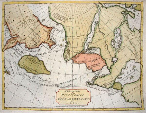
| A General Map of the Discoveries of Admiral De Fonte & Others by M. De L’Isle | ||||||
|---|---|---|---|---|---|---|
| Artist | ||||||
| Title |
A General Map of the Discoveries of Admiral De Fonte & Others by M. De L’Isle |
|||||
| Description |
English: This hand colored map is entitled “A General Map of the Discoveries of Admiral De Fonte & Others by M. De L’Isle” and was published in Gentleman’s Magazine, 1754. This map depicts the mythical Northwest Sea Passage from Atlantic to Pacific proposed by many early navigators. North of California are depicted such fascinating features as the “Sea of the West, Discovered by J. De. Fuca in 1592” and De Fontes Lake just west of Hudson Bay. There are routes labeled for important early explorers who failed to get a real grasp of the region, including, Captian Tchirikow, Routes of Rufses to Kamchatka, passage of St. Anthondy of Padua, etc… There are also many bodies of land described as, “Land seen by Rufses in 1742” or “Land seen by M. Spangburg in 1728.” This map also depicts very important early assumptions regarding the Northern Polar Region. This is a truly important map depicting the hopes and dreams of early American cartography. |
|||||
| Date | 1754 | |||||
| Dimensions | height: 8 in (20.3 cm); width: 10 in (25.4 cm) | |||||
| Accession number |
Geographicus link: DeFonte-1754 |
|||||
| Source/Photographer |
|
|||||
| Permission (Reusing this file) |
|
|||||
File history
Click on a date/time to view the file as it appeared at that time.
| Date/Time | Thumbnail | Dimensions | User | Comment | |
|---|---|---|---|---|---|
| current | 14:32, 24 March 2011 | | 600 × 466 (78 KB) | BotMultichillT (talk | contribs) | {{subst:User:Multichill/Geographicus |link=http://www.geographicus.com/P/AntiqueMap/DeFonte-1754 |product_name=1754 De Fonte Map of the Northwest Passage (America / Asia / Polar) |map_title=A General Map of the Discoveries of Admiral De Fonte & Others by |
You cannot overwrite this file.
File usage on Commons
The following page uses this file:
_-_Geographicus_-_DeFonte-1754.jpg)
_-_Geographicus_-_DeFonte-1754.jpg&oldid=744700561)