File:1762 Janvier Map of North America (Sea of the West) - Geographicus - NorthAmerica-janvier-1762.jpg
Size of this preview: 800 × 551 pixels. Other resolutions: 320 × 220 pixels | 640 × 441 pixels | 1,024 × 706 pixels | 1,280 × 882 pixels | 2,560 × 1,764 pixels | 4,000 × 2,756 pixels.
Original file (4,000 × 2,756 pixels, file size: 2.82 MB, MIME type: image/jpeg)
Captions
Captions
Add a one-line explanation of what this file represents
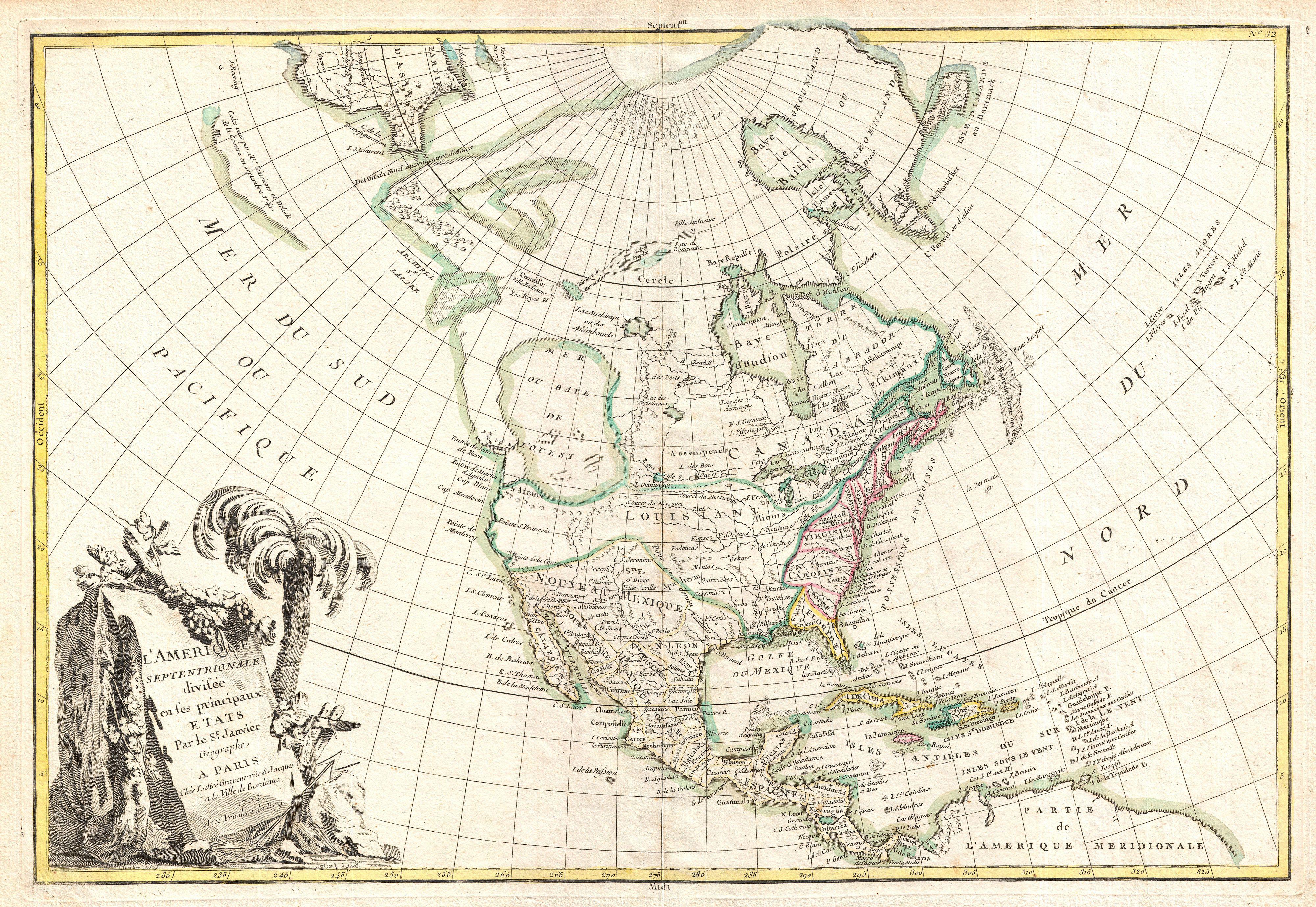
| Jean Janvier: L'Amerique Septentrionale Divisee en ses Principaux Etats
( |
|||||||||||||||||
|---|---|---|---|---|---|---|---|---|---|---|---|---|---|---|---|---|---|
| Artist |
|
||||||||||||||||
| Title |
L'Amerique Septentrionale Divisee en ses Principaux Etats |
||||||||||||||||
| Description |
English: An altogether fascinating map of North America by Jean Janvier dating to 1762. Covers the continent from Panama to the arctic circle, extends westward to include parts of Asia and eastward as far as Iceland. This map, which is heavily influenced by the theoretical mappings of Guillaume de l'Isle and Philippe Buache, went through several states of which this is the first and possibly the most interesting. Javier divides the continent according to the three colonial powers that controlled it, with England controlling the colonies along the east coast, France occupying Canada and Louisiana, and Spain dominating Mexico, Florida, Cuba and Central America. By far the most interesting aspects of this map deal with Janvier's treatment of the largely unexplored Pacific Northwest. A magnificent sea, called the Sea of the West or in this case the Baye de L'Ouest, occupies the greater part of the northwestern part of the continent. This body of water, alternatively called the Sea of the West or Mer de l'Ouest, was speculated by Philippe Buache and Guillaume De l'Isle in the early 18th century based upon wishful thinking, American Indian stories, and the somewhat questionable 16th century explorations of Juan de Fuca. Janvier gives the Mer de l'Ouest its fullest expression, though he specifically does not connect it to either the network of lakes and rivers extending westward form the Hudson Bay or to the similar network extending westward from Lake Superior. These river and lake networks were being actively explored throughout the early 18th century by a number of little known but important French explorers. Most specifically the explorations of Verenrye with regard to the discovery of the Lake of the Woods (L. Des Bois) and Lake Winnipeg (L. Ouinipigon), both of which appear on this map. Further north we can find traces of Admiral de Fonte's apocryphal discovery of a passage from the Pacific (starting at the Archipel St. Lazare) eastward via a network of lakes and rivers to Baffin Bay. The De Fonte legend first appeared in a 1706 English publication entitled “Memoirs of the Curious”. This short-lived magazine published a previously unknown account by a supposed Spanish Admiral named Bartholomew de Fonte. De Fonte is said to have sailed up the Pacific coast of North America in 1640. On this voyage he apparently discovered a series of gigantic lakes, seas, and rivers heading eastward from the Pacific towards Hudson Bay. The De Fonte story relates how, on one of these great inland lakes, he met with a westward bound ship from Boston that must to have come through the Northwest Passage. Today, based upon inaccuracies and falsities, we know the entire De Fonte article to have been a fabrication, however, it set 18th century afire with speculation that a Northwest Passage must indeed exist. Even such luminaries as Benjamin Franklin wrote long defenses of De Fonte. Our map offers an uncommon variant on the De Fonte passage, positioning its western entrada well to the north in order to accommodate the Sea of the West and situating its outlet at the Baffin rather than the Hudson Bay. Even farther to the north we find the Strait of Ainan narrowly separating American from Asia. The extreme northeast tip of Asia is itself fairly well mapped giving evidence to the explorations of Vitus Bering and Tschirikow. Slightly to the south of Asia the cartography is slightly less certain with regard to a questionable landmass in the north Pacific. This mass most likely stems from Tschirikow sightings of the Aleutian Islands and the assumption that they may have been joined. On the opposite side of the map, Janvier places the Great Lakes firmly within French territory, a clear case of carto-advocacy. The English colonies, outlined in red are only vaguely accurate with regard to their borders with Pennsylvania and New Jersey extending north to the Canadian border. |
||||||||||||||||
| Date | 1762 (dated) | ||||||||||||||||
| Dimensions | height: 12.5 in (31.7 cm); width: 18 in (45.7 cm) | ||||||||||||||||
| Accession number |
Geographicus link: NorthAmerica-janvier-1762 |
||||||||||||||||
| Source/Photographer |
Lattre, Jean, Atlas Moderne ou Collection de Cartes sur Toutes les Parties du Globe Terrestre, c. 1775.
|
||||||||||||||||
| Permission (Reusing this file) |
|
||||||||||||||||
File history
Click on a date/time to view the file as it appeared at that time.
| Date/Time | Thumbnail | Dimensions | User | Comment | |
|---|---|---|---|---|---|
| current | 02:11, 23 March 2011 | | 4,000 × 2,756 (2.82 MB) | BotMultichillT (talk | contribs) | {{subst:User:Multichill/Geographicus |link=http://www.geographicus.com/P/AntiqueMap/NorthAmerica-janvier-1762 |product_name=1762 Janvier Map of North America (Sea of the West) |map_title=L'Amerique Septentrionale Divisee en ses Principaux Etats |descripti |
You cannot overwrite this file.
File usage on Commons
The following page uses this file:
_-_Geographicus_-_NorthAmerica-janvier-1762.jpg)
_-_Geographicus_-_NorthAmerica-janvier-1762.jpg&oldid=784177235)