File:1762 Janvier Map of Scandinavia - Norway, Sweden, Denmark, Finland - Geographicus - Scandinavia-janvier-1762.jpg

Size of this preview: 800 × 552 pixels. Other resolutions: 320 × 221 pixels | 640 × 441 pixels | 1,024 × 706 pixels | 1,280 × 883 pixels | 2,560 × 1,765 pixels | 4,000 × 2,758 pixels.
Original file (4,000 × 2,758 pixels, file size: 3.34 MB, MIME type: image/jpeg)
Captions
Captions
Add a one-line explanation of what this file represents
| Jean Janvier: Les Couronnes du Nord Comprenant Les Royaumes de Suede Danemarck et Norwege divisees par Provinces et Gouvernements.
( |
|||||||||||||||||
|---|---|---|---|---|---|---|---|---|---|---|---|---|---|---|---|---|---|
| Artist |
|
||||||||||||||||
| Title |
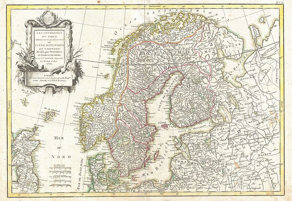
Les Couronnes du Nord Comprenant Les Royaumes de Suede Danemarck et Norwege divisees par Provinces et Gouvernements. |
||||||||||||||||
| Description |
English: A beautiful example of Jan Janvier's 1762 decorative map of Scandinavia. Covers from Iceland and England eastward as far as Moscow, north to the Arctic Sea, and south as far as Denmark and Germany. Includes the modern day nations of Sweden, Denmark, Norway, and Finland. Identifies towns, cities, rivers, mountains, and some undersea features. Of particular interest is the legendary Lofoten Maelstrom in northwestern Norway. This legendary whirlpool was the inspiration for Edgar Allan Poe's classic tale "A Descent into the Maelstrom". In reality, it is a periodic and powerful current caused by tidal variations in the region. A large decorative title cartouche appears in the upper left quadrant. Drawn by J. Janvier c. 1762 for issue as plate no. 21 in Jean Lattre's 1776 issue of the Atlas Moderne . |
||||||||||||||||
| Date | 1762 (dated) | ||||||||||||||||
| Dimensions | height: 12.5 in (31.7 cm); width: 16 in (40.6 cm) | ||||||||||||||||
| Accession number |
Geographicus link: Scandinavia-janvier-1762 |
||||||||||||||||
| Source/Photographer |
Lattre, Jean, Atlas Moderne ou Collection de Cartes sur Toutes les Parties du Globe Terrestre, c. 1775.
|
||||||||||||||||
| Permission (Reusing this file) |
|
||||||||||||||||
File history
Click on a date/time to view the file as it appeared at that time.
| Date/Time | Thumbnail | Dimensions | User | Comment | |
|---|---|---|---|---|---|
| current | 17:22, 23 March 2011 | | 4,000 × 2,758 (3.34 MB) | BotMultichillT (talk | contribs) | {{subst:User:Multichill/Geographicus |link=http://www.geographicus.com/P/AntiqueMap/Scandinavia-janvier-1762 |product_name=1762 Janvier Map of Scandinavia - Norway, Sweden, Denmark, Finland |map_title=Les Couronnes du Nord Comprenant Les Royaumes de Suede |
You cannot overwrite this file.
File usage on Commons
The following page uses this file:
File usage on other wikis
The following other wikis use this file:
- Usage on en.wikipedia.org
- Usage on fi.wikipedia.org
- Usage on no.wikipedia.org