File:1770 Bonne Map of Chinese Tartary, Mongolia, Manchuria and Korea (Corea) - Geographicus - TartarieChine-bonne-1770.jpg
Size of this preview: 800 × 584 pixels. Other resolutions: 320 × 234 pixels | 640 × 468 pixels | 1,024 × 748 pixels | 1,280 × 935 pixels | 2,560 × 1,870 pixels | 4,000 × 2,922 pixels.
Original file (4,000 × 2,922 pixels, file size: 3.88 MB, MIME type: image/jpeg)
Captions
Captions
Add a one-line explanation of what this file represents
Summary edit
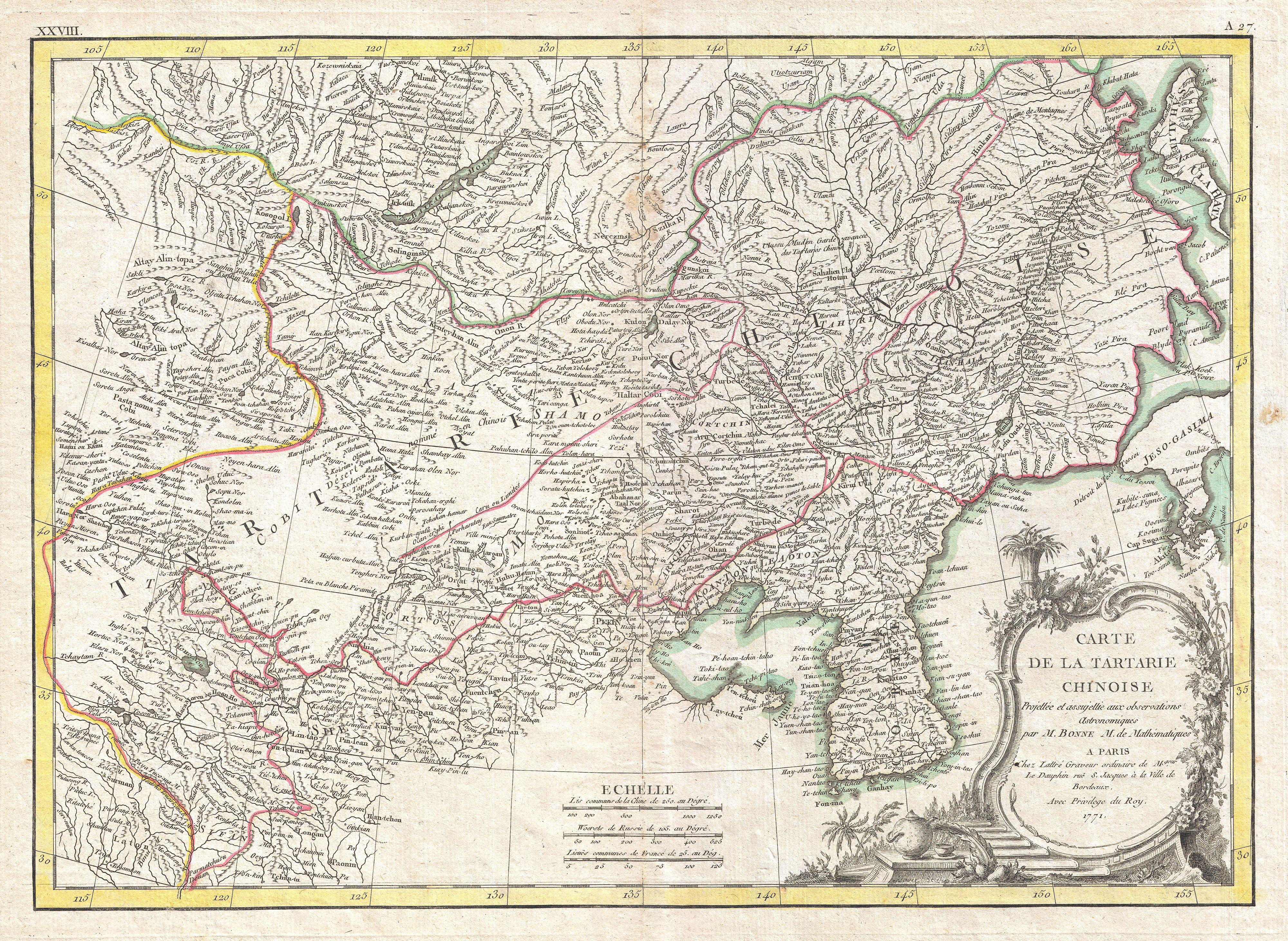
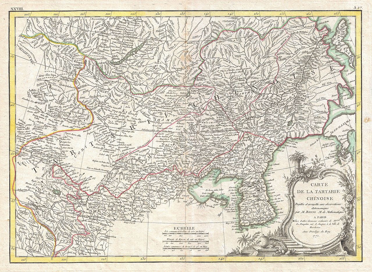
| Rigobert Bonne: Carte deLa Tartarie Chinoise.
( |
|||||||||||||||||||||||
|---|---|---|---|---|---|---|---|---|---|---|---|---|---|---|---|---|---|---|---|---|---|---|---|
| Artist |
|
||||||||||||||||||||||
| Title |
Carte deLa Tartarie Chinoise. |
||||||||||||||||||||||
| Description |
English: A beautiful example of Rigobert Bonne's 1770 decorative map of Chinese Tartary. Covers from the Lop Nor region eastward to Korea, Manchuria, Sakalin and Jeso-Gasima (Hokkaido). Includes both Inner Mongolia and Outer Mongolia. Extends north to include Lake Baikal. Names numerous towns, cities and river systems. Shows the Great Wall of China. At the far eastern extreme of this map Jeso-Gasimia, or Hokkaido, is mapped speculatively along its northern shore. The island of Sahalien (or Sakhalin) also appears with erroneous shores. A decorative title cartouche appears in the lower right corner. This is an uncommon and rarely seen map. Drawn by R. Bonne in 1770 for issue as plate no. A 27 in Jean Lattre's 1776 issue of the Atlas Moderne . |
||||||||||||||||||||||
| Date | 1771 (dated) | ||||||||||||||||||||||
| Dimensions | height: 12 in (30.4 cm); width: 17 in (43.1 cm) | ||||||||||||||||||||||
| Accession number |
Geographicus link: TartarieChine-bonne-1770 |
||||||||||||||||||||||
| Source/Photographer |
Lattre, Jean, Atlas Moderne ou Collection de Cartes sur Toutes les Parties du Globe Terrestre, c. 1775.
|
||||||||||||||||||||||
| Permission (Reusing this file) |
|
||||||||||||||||||||||
| Other versions |
|
||||||||||||||||||||||

.jpg)

_-_Geographicus_-_TartarieChine-bonne-1770.jpg&action=edit§ion=1)
File history
Click on a date/time to view the file as it appeared at that time.
| Date/Time | Thumbnail | Dimensions | User | Comment | |
|---|---|---|---|---|---|
| current | 03:13, 23 March 2011 | | 4,000 × 2,922 (3.88 MB) | BotMultichillT (talk | contribs) | {{subst:User:Multichill/Geographicus |link=http://www.geographicus.com/P/AntiqueMap/TartarieChine-bonne-1770 |product_name=1770 Bonne Map of Chinese Tartary, Mongolia, Manchuria and Korea (Corea) |map_title=Carte deLa Tartarie Chinoise. |description=A bea |
You cannot overwrite this file.
File usage on Commons
The following 4 pages use this file:
- File:1770 Bonne Map of Chinese Tartary, Mongolia, Manchuria and Korea (Corea) - Geographicus - TartarieChine-bonne-1770.jpg
- File:A map of Chinese Tartary, with Corea (NYPL b13919861-5207424).jpg
- File:A map of Chinese Tartary, with Corea (NYPL b13919861-5207424).tiff
- File:Carte de la Tartarie Chinoise Projettée et assujettie aux observations Astronomiques - par M. Bonne... - btv1b530705277.jpg
_-_Geographicus_-_TartarieChine-bonne-1770.jpg)
File usage on other wikis
The following other wikis use this file:
- Usage on en.wikipedia.org
_-_Geographicus_-_TartarieChine-bonne-1770.jpg&oldid=744718633)