File:1771 Bonne Map of Dauphine and Provence, France - Geographicus - Provence-bonne-1771.jpg
Size of this preview: 436 × 599 pixels. Other resolutions: 175 × 240 pixels | 349 × 480 pixels | 559 × 768 pixels | 746 × 1,024 pixels | 2,549 × 3,500 pixels.
Original file (2,549 × 3,500 pixels, file size: 2.8 MB, MIME type: image/jpeg)
Captions
Captions
Add a one-line explanation of what this file represents
Summary edit
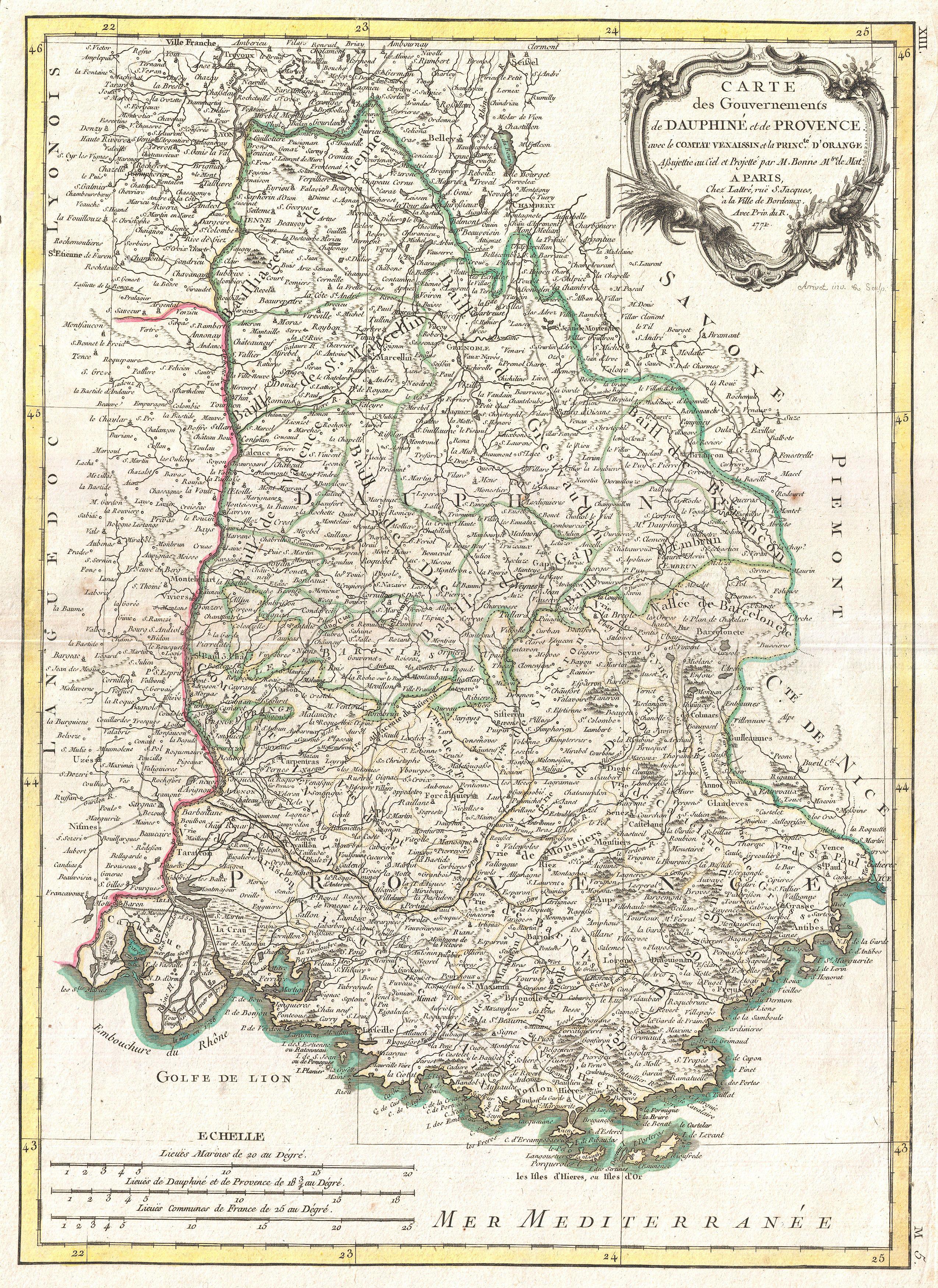
| Rigobert Bonne: Carte des Gouvernements de Dauphine et de Provence avec le Comtat Venaissin et la Princte. D'Orange.
( |
|||||||||||||||||||||||
|---|---|---|---|---|---|---|---|---|---|---|---|---|---|---|---|---|---|---|---|---|---|---|---|
| Artist |
|
||||||||||||||||||||||
| Title |
Carte des Gouvernements de Dauphine et de Provence avec le Comtat Venaissin et la Princte. D'Orange. |
||||||||||||||||||||||
| Description |
English: A beautiful example of Rigobert Bonne's decorative map of the French regions of Provence and Dauphine. Covers the region in full from Savoy to the Mediterranean and from Languedoc to Nice. This region, known as the playground of Europe's elite, is admired for its stunning natural beauty, distinctive culture, superb cuisine, delightful beaches, and fantastic wines. Identifies Nice, Cannes, St. Tropez, Toulon, and many other cities. A large decorative title cartouche appears in the upper right quadrant. Drawn by R. Bonne in 1771 for issue as plate no. M 5 in Jean Lattre's 1776 issue of the Atlas Moderne . |
||||||||||||||||||||||
| Date | 1771 (dated) | ||||||||||||||||||||||
| Dimensions | height: 16.5 in (41.9 cm); width: 12 in (30.4 cm) | ||||||||||||||||||||||
| Accession number |
Geographicus link: Provence-bonne-1771 |
||||||||||||||||||||||
| Source/Photographer |
Lattre, Jean, Atlas Moderne ou Collection de Cartes sur Toutes les Parties du Globe Terrestre, c. 1775.
|
||||||||||||||||||||||
Licensing edit
|
This is a faithful photographic reproduction of a two-dimensional, public domain work of art. The work of art itself is in the public domain for the following reason:
The official position taken by the Wikimedia Foundation is that "faithful reproductions of two-dimensional public domain works of art are public domain".
This photographic reproduction is therefore also considered to be in the public domain in the United States. In other jurisdictions, re-use of this content may be restricted; see Reuse of PD-Art photographs for details. | ||||
File history
Click on a date/time to view the file as it appeared at that time.
| Date/Time | Thumbnail | Dimensions | User | Comment | |
|---|---|---|---|---|---|
| current | 18:12, 23 March 2011 | | 2,549 × 3,500 (2.8 MB) | BotMultichillT (talk | contribs) | {{subst:User:Multichill/Geographicus |link=http://www.geographicus.com/P/AntiqueMap/Provence-bonne-1771 |product_name=1771 Bonne Map of Dauphine and Provence, France |map_title=Carte des Gouvernements de Dauphine et de Provence avec le Comtat Venaissin et |
You cannot overwrite this file.
File usage on Commons
The following page uses this file: