File:1771 Zannoni Map of the British Isles (England, Scotland, Ireland) - Geographicus - BritishIsles-janvier-1771.jpg

Size of this preview: 800 × 554 pixels. Other resolutions: 320 × 221 pixels | 640 × 443 pixels | 1,024 × 709 pixels | 1,280 × 886 pixels | 2,560 × 1,772 pixels | 3,500 × 2,422 pixels.
Original file (3,500 × 2,422 pixels, file size: 2.26 MB, MIME type: image/jpeg)
Captions
Captions
Add a one-line explanation of what this file represents
| Jean Janvier: Les Isles Britanniques Comprenant les Royaumes D'Angleterre, D'Ecosse et D'Irlande divisee en grands provinces.
( |
|||||||||||||||||
|---|---|---|---|---|---|---|---|---|---|---|---|---|---|---|---|---|---|
| Artist |
|
||||||||||||||||
| Title |
Les Isles Britanniques Comprenant les Royaumes D'Angleterre, D'Ecosse et D'Irlande divisee en grands provinces. |
||||||||||||||||
| Description |
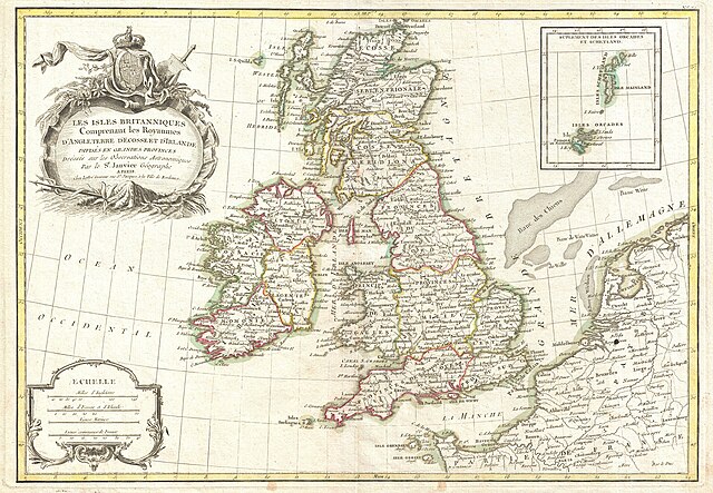
English: A beautiful example of Janvier's 1771 decorative map of the British Isles. Includes all of England, Scotland and Ireland as well as parts of adjacent France, Holland and Belgium. Divided according to Province. An inset in the upper right details the Shetland and Orkney Islands. A decorative mile scale appears in the lower left quadrant. A decorative title cartouche depicting the British royal armorial crest appears in the upper left quadrant. Drawn by J. Janvier c. 1771 for issue as plate no. 20 in Jean Lattre's 1776 issue of the Atlas Moderne . |
||||||||||||||||
| Date | 1771 (undated) | ||||||||||||||||
| Dimensions | height: 12.5 in (31.7 cm); width: 15.5 in (39.3 cm) | ||||||||||||||||
| Accession number |
Geographicus link: BritishIsles-janvier-1771 |
||||||||||||||||
| Source/Photographer |
Lattre, Jean, Atlas Moderne ou Collection de Cartes sur Toutes les Parties du Globe Terrestre, c. 1775.
|
||||||||||||||||
| Permission (Reusing this file) |
|
||||||||||||||||
File history
Click on a date/time to view the file as it appeared at that time.
| Date/Time | Thumbnail | Dimensions | User | Comment | |
|---|---|---|---|---|---|
| current | 04:04, 23 March 2011 | | 3,500 × 2,422 (2.26 MB) | BotMultichillT (talk | contribs) | {{subst:User:Multichill/Geographicus |link=http://www.geographicus.com/P/AntiqueMap/BritishIsles-janvier-1771 |product_name=1771 Zannoni Map of the British Isles ( England, Scotland , Ireland ) |map_title=Les Isles Britanniques Comprenant les Royaumes D'A |
You cannot overwrite this file.
File usage on Commons
The following 2 pages use this file:
_-_Geographicus_-_BritishIsles-janvier-1771.jpg)
_-_Geographicus_-_BritishIsles-janvier-1771.jpg&redirect=no)
File usage on other wikis
The following other wikis use this file:
- Usage on de.wikipedia.org
- Usage on hu.wikipedia.org
- Usage on nl.wikipedia.org
_-_Geographicus_-_BritishIsles-janvier-1771.jpg&oldid=744719236)