File:1794 Delarochette Wall Map of the Empire of Germany - Geographicus - Germany-delarochette-1794.jpg

Original file (8,000 × 7,128 pixels, file size: 20.36 MB, MIME type: image/jpeg)
Captions
Captions
Summary edit
| Warning | The original file is very high-resolution. It might not load properly or could cause your browser to freeze when opened at full size. |
|---|
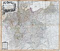
| Map of the Empire of Germany, Including All the States Comprehended under that Name: with the Kingdom of Prussia, &c. | |||
|---|---|---|---|
| Artist | |||
| Title |
Map of the Empire of Germany, Including All the States Comprehended under that Name: with the Kingdom of Prussia, &c. |
||
| Description |
English: An absolutely stunning and monumental two panel 1794 wall map of Germany, Bohemia, Austria and Prussia by Louis Stanislas d'Arcy Delarochette. Covers Germanic territories in full from the Baltic Sea to the Gulf of Venice. Includes Germany, Austria, Bohemia (Czech Republic), Poland, Lithuania, Prussia, Switzerland, Holland (the Netherlands), Belgium and Denmark. Offers an extraordinary level of detail throughout, noting roadways, towns, castles, monasteries, forests, swamps, rivers, cities and mountains. Even offers some offshore detail near Belgium and Holland. An elaborate allegorical title cartouche in the upper left quadrant depicts the German janiform eagle overlooking two warrior women and an assortment of military paraphernalia. Under it all, a baleful Medusa looks on. this is the 1794 updated edition of a map originally published in 1759. Published by Laurie and Whittle as plate nos. 18-19 in the 1797 edition of Thomas Kitchin's General Atlas . |
||
| Date | 1794 (dated) | ||
| Dimensions |
height: 42 in (106.6 cm); width: 48 in (121.9 cm) dimensions QS:P2048,42U218593 dimensions QS:P2049,48U218593 |
||
| Accession number |
Geographicus link: Germany-delarochette-1794 |
||
| Source/Photographer |
Kitchin, Thomas, Kitchin's General Atlas, describing the Whole Universe: being a complete collection of the most approved maps extant; corrected with the greatest care, and augmented from the last edition of D'Anville and Robert with many improvements by other eminent geographers, engraved on Sixty-Two plates, comprising Thirty Seven maps., Laurie & Whittle, London, 1797.
|
||
| Other versions |
|
||
Licensing edit
| Public domainPublic domainfalsefalse |
|
This work is in the public domain in its country of origin and other countries and areas where the copyright term is the author's life plus 100 years or fewer. This work is in the public domain in the United States because it was published (or registered with the U.S. Copyright Office) before January 1, 1929. | |
| This file has been identified as being free of known restrictions under copyright law, including all related and neighboring rights. | |
https://creativecommons.org/publicdomain/mark/1.0/PDMCreative Commons Public Domain Mark 1.0falsefalse
File history
Click on a date/time to view the file as it appeared at that time.
| Date/Time | Thumbnail | Dimensions | User | Comment | |
|---|---|---|---|---|---|
| current | 04:50, 23 March 2011 |  | 8,000 × 7,128 (20.36 MB) | BotMultichillT (talk | contribs) | {{subst:User:Multichill/Geographicus |link=http://www.geographicus.com/P/AntiqueMap/Germany-delarochette-1794 |product_name=1794 Delarochette Wall Map of the Empire of Germany |map_title=Map of the Empire of Germany, Including All the States Comprehended |
You cannot overwrite this file.
File usage on Commons
The following 4 pages use this file:
- File:1794 Delarochette Wall Map of the Empire of Germany - Geographicus - Germany-delarochette-1794.jpg
- File:Map of the Empire of Germany, north side (Delarochette, 1794).jpg
- File:Map of the Empire of Germany, south side (Delarochette, 1794).jpg
- File:Map of the Empire of Germany (Delarochette, 1794).jpg
File usage on other wikis
The following other wikis use this file:
- Usage on fr.wikipedia.org
- Usage on lt.wikipedia.org
- Usage on lt.wikibooks.org


