File:17 Map of Tamana, Kiribati.jpg

Size of this preview: 524 × 600 pixels. Other resolutions: 210 × 240 pixels | 419 × 480 pixels | 768 × 879 pixels.
Original file (768 × 879 pixels, file size: 383 KB, MIME type: image/jpeg)
Captions
Captions
Add a one-line explanation of what this file represents
Summary edit
| Description |
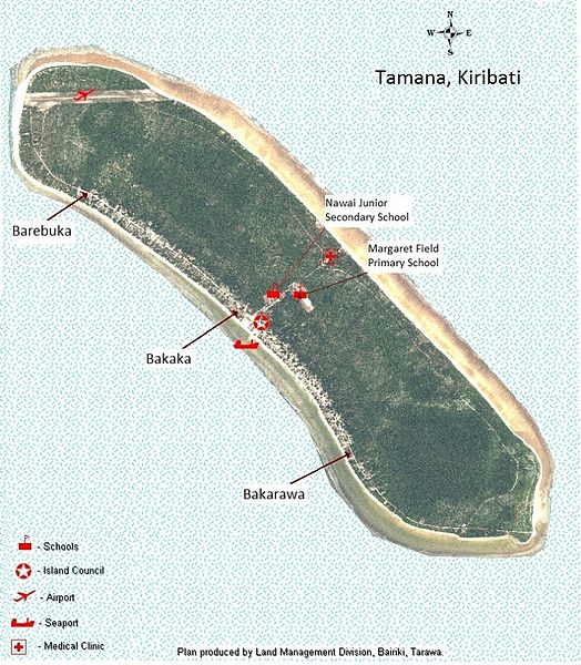
English: Astronaut photo of Tamana, Kiribati with villages and main landmarks |
| Date | |
| Source | Astronaut photo/ Government of Kiribati mapping information |
| Author | Government of USA, Government of Kiribati |
| Permission (Reusing this file) |
Licensing edit
This file is licensed under the Creative Commons Attribution-Share Alike 3.0 Unported license.
- You are free:
- to share – to copy, distribute and transmit the work
- to remix – to adapt the work
- Under the following conditions:
- attribution – You must give appropriate credit, provide a link to the license, and indicate if changes were made. You may do so in any reasonable manner, but not in any way that suggests the licensor endorses you or your use.
- share alike – If you remix, transform, or build upon the material, you must distribute your contributions under the same or compatible license as the original.
= Copyright release letter is at 01 Map of Makin, Kiribati
File history
Click on a date/time to view the file as it appeared at that time.
| Date/Time | Thumbnail | Dimensions | User | Comment | |
|---|---|---|---|---|---|
| current | 01:32, 11 March 2013 | | 768 × 879 (383 KB) | Obkiribati1 (talk | contribs) | {{Information |Description ={{en|1=Astronaut photo of Tamana, Kiribati with villages and main landmarks}} |Source =Astronaut photo/ Government of Kiribati mapping information |Author =Government of USA, Government of Kiribati |Date ... |
You cannot overwrite this file.
File usage on Commons
There are no pages that use this file.