File:1802 Tardieu Map of Santo Domingo or Hispaniola, West Indies - Geographicus - StDomingue2-tardieu-1802.jpg
Size of this preview: 742 × 600 pixels. Other resolutions: 297 × 240 pixels | 594 × 480 pixels | 950 × 768 pixels | 1,267 × 1,024 pixels | 2,533 × 2,048 pixels | 4,000 × 3,234 pixels.
Original file (4,000 × 3,234 pixels, file size: 1.6 MB, MIME type: image/jpeg)
Captions
Captions
Add a one-line explanation of what this file represents
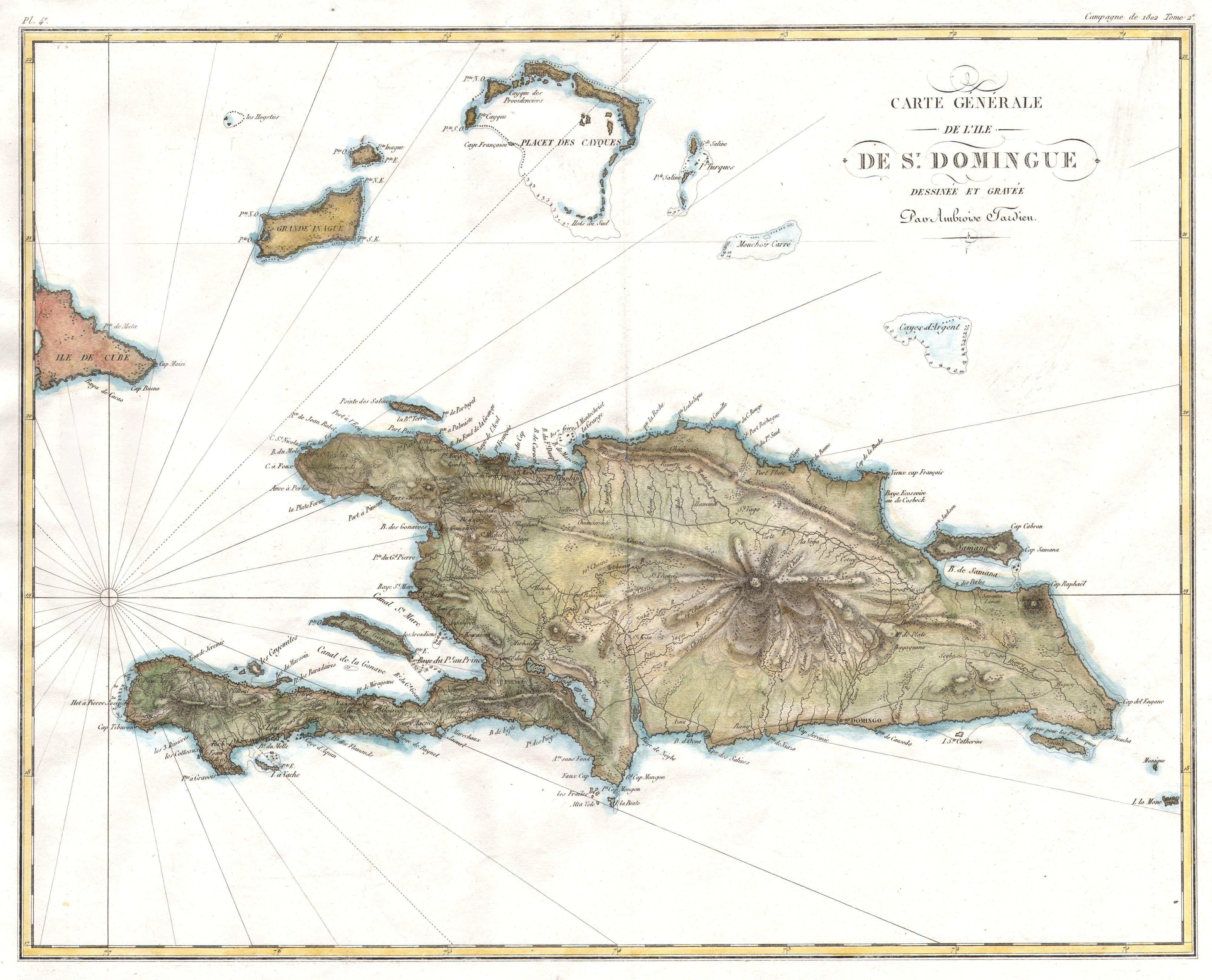
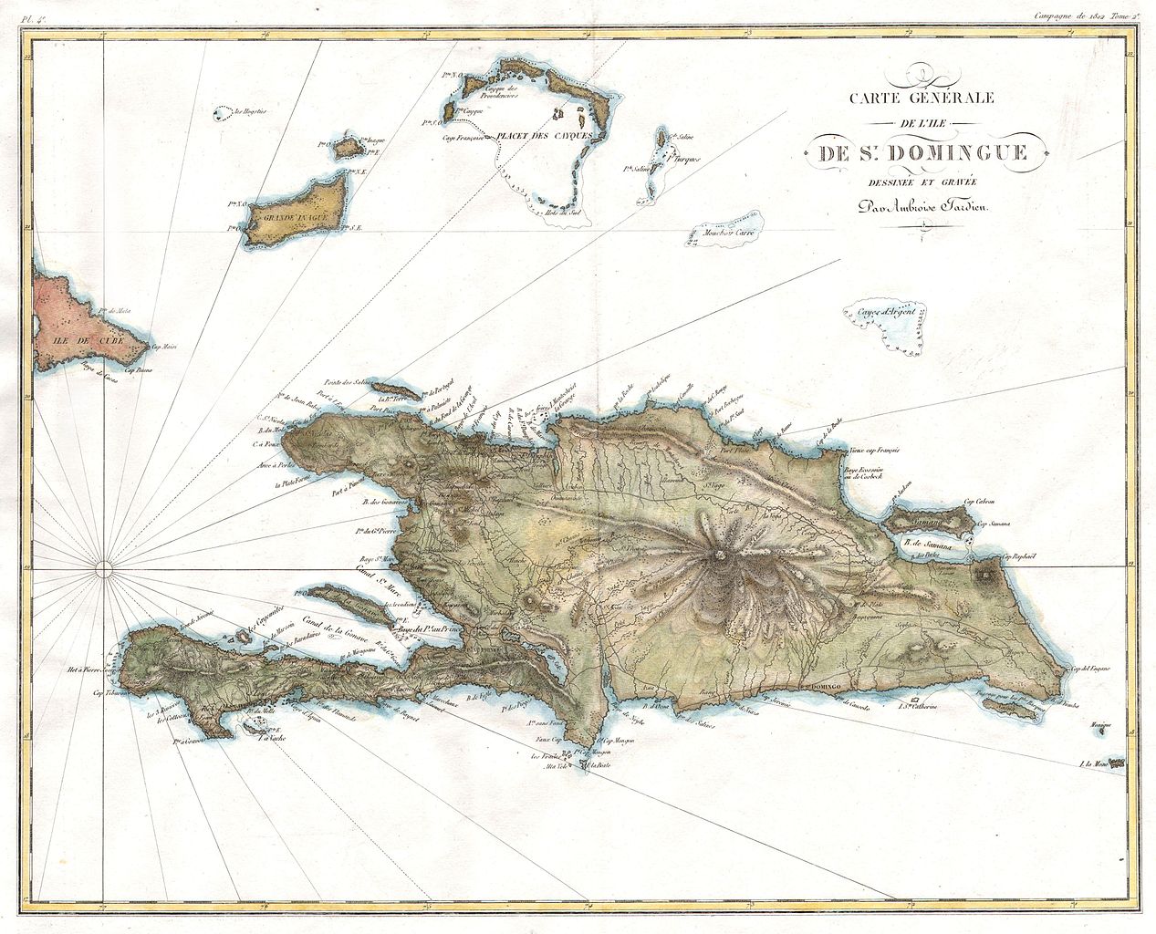
| Carte Générale de l'Ile de St. Domingue. | ||||||
|---|---|---|---|---|---|---|
| Artist | ||||||
| Title |
Carte Générale de l'Ile de St. Domingue. |
|||||
| Description |
English: A rare and beautiful 1802 map of the West Indies island of Hispaniola or Santo Domingo ( St. Domingue ) by Ambroise Tardieu. This rare and stunning map depicts the island with all of Tardieu’s glorious hallmark detail. Roads, topography, cities, and occasional depth soundings are rendered with meticulous care. Map includes the island itself as well as parts of Cuba and Les Caicos ( Cayques ). This map was originally prepared for inclusion in atlas volume of General Comte Mathieu Dumas’s 8 volume Precis Des Evenemens Militaires, a history of French military campaigns during the Napoleonic era.
Français : Une rare et magnifique carte de l'île antillaise de Saint-Domingue par Ambroise Tardieu, datée de 1802. |
|||||
| Date | 1802 | |||||
| Dimensions | height: 14.5 in (36.8 cm); width: 18.5 in (46.9 cm) | |||||
| Accession number |
Geographicus link: StDomingue2-tardieu-1802 |
|||||
| Source/Photographer |
|
|||||
| Permission (Reusing this file) |
|
|||||
File history
Click on a date/time to view the file as it appeared at that time.
| Date/Time | Thumbnail | Dimensions | User | Comment | |
|---|---|---|---|---|---|
| current | 13:36, 24 March 2011 | | 4,000 × 3,234 (1.6 MB) | BotMultichillT (talk | contribs) | {{subst:User:Multichill/Geographicus |link=http://www.geographicus.com/P/AntiqueMap/StDomingue2-tardieu-1802 |product_name=1802 Tardieu Map of Santo Domingo or Hispaniola, West Indies |map_title=Carte Générale de l'Ile de St. Domingue. |description= |
You cannot overwrite this file.
File usage on Commons
The following page uses this file:
File usage on other wikis
The following other wikis use this file:
- Usage on fr.wikipedia.org