File:1806 Cary Map of the Western Hemisphere ( North America and South America ) - Geographicus - America-cary-1806.jpg
Size of this preview: 671 × 599 pixels. Other resolutions: 269 × 240 pixels | 538 × 480 pixels | 860 × 768 pixels | 1,147 × 1,024 pixels | 2,293 × 2,048 pixels | 5,000 × 4,465 pixels.
Original file (5,000 × 4,465 pixels, file size: 7.1 MB, MIME type: image/jpeg)
Captions
Captions
Add a one-line explanation of what this file represents
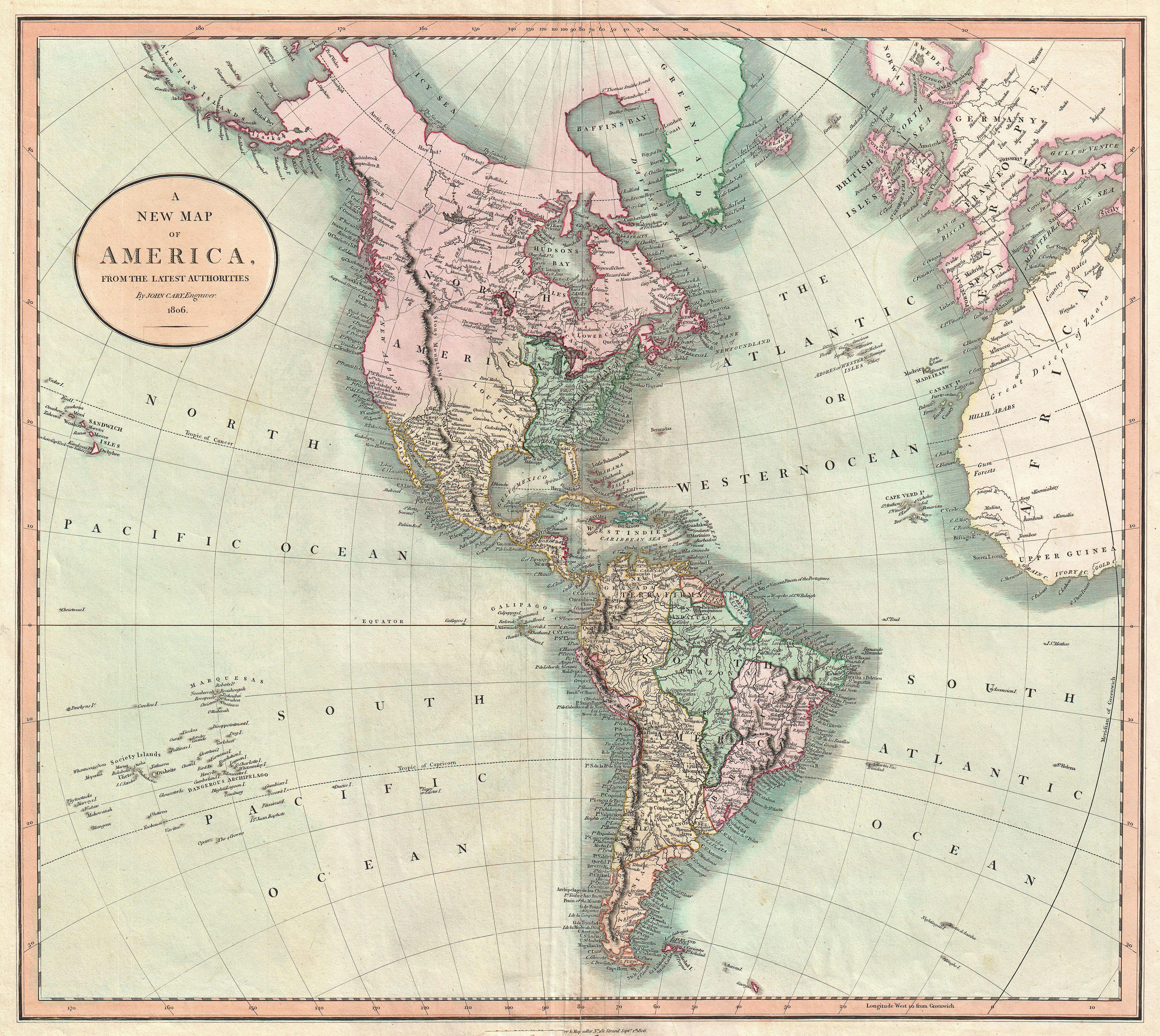
| John Cary: A New Map of America, from the Latest Authorities.
( |
||||||||||||||||||||||||||
|---|---|---|---|---|---|---|---|---|---|---|---|---|---|---|---|---|---|---|---|---|---|---|---|---|---|---|
| Artist |
|
|||||||||||||||||||||||||
| Title |
A New Map of America, from the Latest Authorities. |
|||||||||||||||||||||||||
| Description |
English: An exceptionally beautiful example of John Cary’s important 1806 Map of North and South America. Covers the entirety of the Western Hemisphere with a focus on North and South America. In North America the fledgling United States extends westward only so far as the Mississippi River. Florida is divided at the Apalachicola River into eastern and western sections. West Florida, ostensibly part of the Louisiana Purchase, was claimed by the Spanish and remained under their control until 1812. East Florida remained under Spanish control until 1821. The South America portion of the map is notable for its excellent detail in the Amazon basin and the massive Spanish holdings extending from Panama south to Patagonia. East of the Falkland’s the mythical Aurora Island is noted. All in all, one of the most interesting and attractive atlas maps of the Western Hemisphere to appear in first years of the 19th century. Prepared in 1805 by John Cary for issue in his magnificent 1808 New Universal Atlas . |
|||||||||||||||||||||||||
| Date | 1806 (dated) | |||||||||||||||||||||||||
| Dimensions | height: 18.5 in (46.9 cm); width: 20.7 in (52.7 cm) | |||||||||||||||||||||||||
| Accession number |
Geographicus link: America-cary-1806 |
|||||||||||||||||||||||||
| Source/Photographer |
Cary, John, Cary's New Universal Atlas, containing distinct maps of all the principal states and kingdoms throughout the World. From the latest and best authorities extant. London: Printed for J. Cary, Engraver and Map-seller, No. 181, near Norfolk Street, Strand, 1808.
|
|||||||||||||||||||||||||
| Permission (Reusing this file) |
|
|||||||||||||||||||||||||
File history
Click on a date/time to view the file as it appeared at that time.
| Date/Time | Thumbnail | Dimensions | User | Comment | |
|---|---|---|---|---|---|
| current | 10:38, 22 March 2011 | | 5,000 × 4,465 (7.1 MB) | BotMultichillT (talk | contribs) | {{subst:User:Multichill/Geographicus |link=http://www.geographicus.com/P/AntiqueMap/America-cary-1806 |product_name=1806 Cary Map of the Western Hemisphere ( North America and South America ) |map_title=A New Map of America, from the Latest Authorities. | |
You cannot overwrite this file.
File usage on Commons
The following page uses this file:
_-_Geographicus_-_America-cary-1806.jpg)
_-_Geographicus_-_America-cary-1806.jpg&oldid=744892438)