File:1833 Map of Iredell County showing Concord and Bethany Churches.tif

Size of this JPG preview of this TIF file: 776 × 600 pixels. Other resolutions: 311 × 240 pixels | 621 × 480 pixels | 961 × 743 pixels.
Original file (961 × 743 pixels, file size: 1.77 MB, MIME type: image/tiff)
Captions
Captions
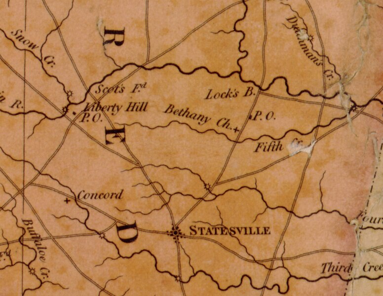
1833 Map of Iredell County, North Carolina showing Concord and Bethany Presbyterian churches
Summary edit
| Description |
English: Portion of 1833 Map of North Carolina by Robert Brazier showing the area around Statesville, Iredell County. Includes local churches. |
| Date | |
| Source | https://www.loc.gov/item/2006459002/ |
| Author |
Contributor Names Brazier, Robert H. B. Created / Published Fayetteville, N.C. : Published under the patronage of the legislature by John Mac Rae ; Philadelphia : H.S. Tanner, 1833. |
Licensing edit
|
This work is in the public domain in its country of origin and other countries and areas where the copyright term is the author's life plus 70 years or fewer. This work is in the public domain in the United States because it was published (or registered with the U.S. Copyright Office) before January 1, 1929. | |
| This file has been identified as being free of known restrictions under copyright law, including all related and neighboring rights. | |
File history
Click on a date/time to view the file as it appeared at that time.
| Date/Time | Thumbnail | Dimensions | User | Comment | |
|---|---|---|---|---|---|
| current | 14:03, 12 August 2019 |  | 961 × 743 (1.77 MB) | G. Moore (talk | contribs) | User created page with UploadWizard |
You cannot overwrite this file.
File usage on Commons
There are no pages that use this file.
File usage on other wikis
The following other wikis use this file: