File:1833 map of Budapest by László Vörös.jpg

Size of this preview: 800 × 409 pixels. Other resolutions: 320 × 164 pixels | 640 × 328 pixels | 1,024 × 524 pixels | 1,280 × 655 pixels | 2,560 × 1,310 pixels | 30,000 × 15,353 pixels.
Original file (30,000 × 15,353 pixels, file size: 94.67 MB, MIME type: image/jpeg)
Captions
Captions
Add a one-line explanation of what this file represents
Summary edit
| Warning | The original file is very high-resolution. It might not load properly or could cause your browser to freeze when opened at full size. |
|---|
| Description |
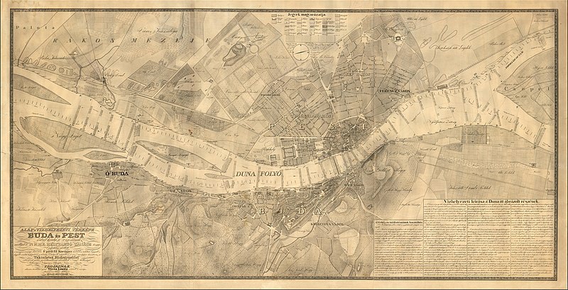
English: 1833 map of Budapest by László Vörös
Magyar: Alap's Vizhelyezeti Térképe Buda és Pest szabad király fő városainak, mellyet á N.M.M.K. Helytartó Tanács kegyes Engedelme mellett á magyar országi Tekintetes Epito fő Kormány . . . Tagjainak alarzatos tisztelettel ajánl Vörös László á kiadó és országos dunamérési hiteles földmérő. Budan MDCCCXXXIII. |
| Date | |
| Source | https://www.raremaps.com/gallery/detail/57469/alaps-vizhelyezeti-terkepe-buda-es-pest-szabad-kiraly-f- |
| Author | László Vörös. |
Licensing edit
|
This work is in the public domain in its country of origin and other countries and areas where the copyright term is the author's life plus 70 years or fewer. This work is in the public domain in the United States because it was published (or registered with the U.S. Copyright Office) before January 1, 1929. | |
| This file has been identified as being free of known restrictions under copyright law, including all related and neighboring rights. | |
File history
Click on a date/time to view the file as it appeared at that time.
| Date/Time | Thumbnail | Dimensions | User | Comment | |
|---|---|---|---|---|---|
| current | 09:36, 11 June 2020 | | 30,000 × 15,353 (94.67 MB) | Balkanique (talk | contribs) | Uploaded a work by László Vörös. from https://www.raremaps.com/gallery/detail/57469/alaps-vizhelyezeti-terkepe-buda-es-pest-szabad-kiraly-f- with UploadWizard |
You cannot overwrite this file.
File usage on Commons
The following 2 pages use this file: