File:1836 Provincetown US Topographical Bureau.jpg
Original file (5,760 × 4,800 pixels, file size: 1.29 MB, MIME type: image/jpeg)
Captions
Captions
Summary edit
| Description |
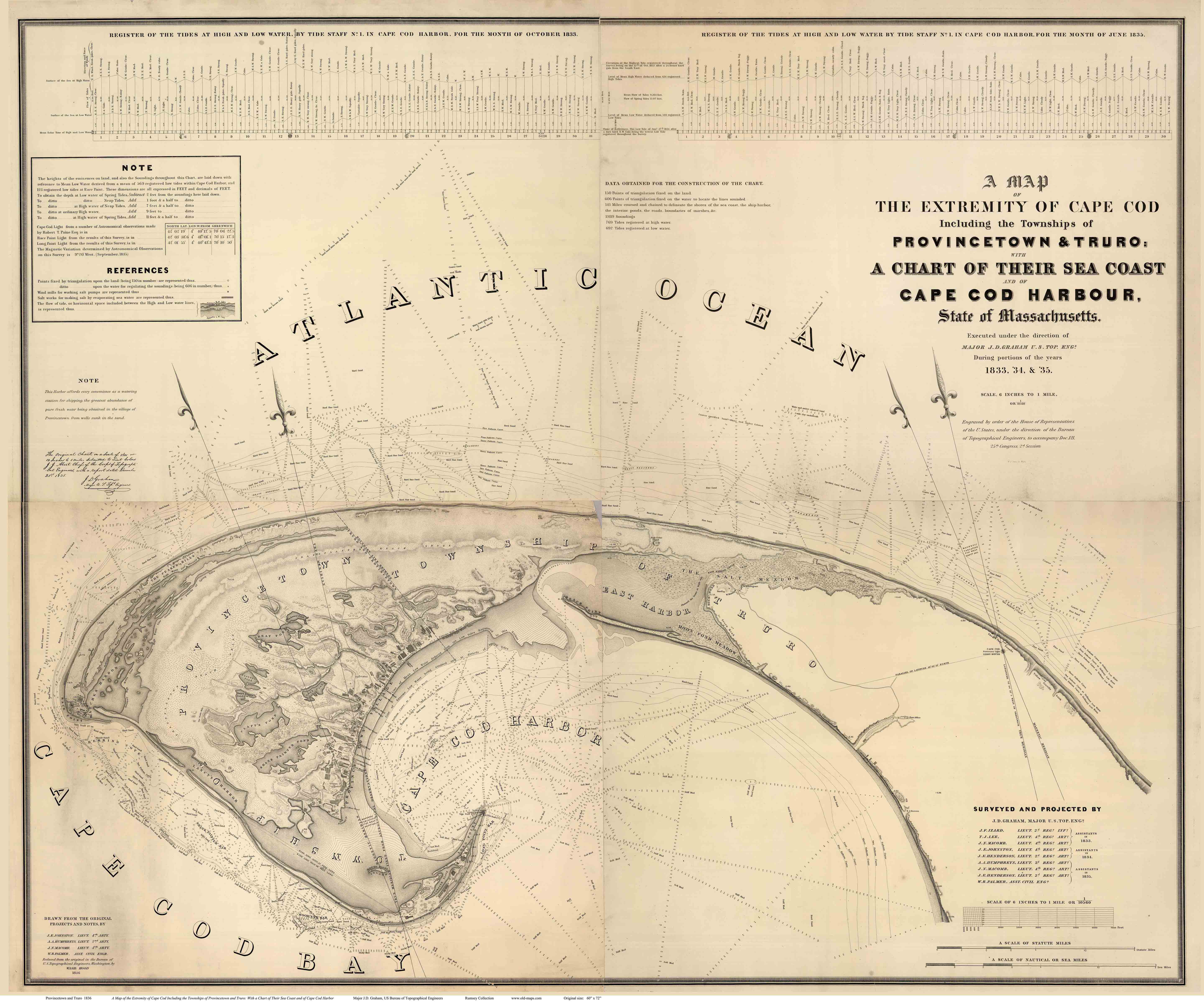
Title: "A Map Of The Extremity Of Cape Cod Including the Townships of Provincetown & Truro: A Chart Of Their Sea Coast And Of Cape Cod Harbour, State of Massachusetts" Executed under the direction of Major J.D. Graham U.S. Top. Engs. During portions of the years 1833,'34, &'35 ... W.J. Stone Sc. Wash. Surveyed And Projected By J.D. Graham ... Drawn From The Original Projects And Notes, By J.E. Johnston ... A.A. Humphreys .... J.. Macomb ... W.R. Palmer ... Reduced from the original in the Bureau of U.S. Topographical Engineers, Washington, by Wash: Hood 1836. List No: 2433.005 Series No: 5 Engraver or Printer: Stone, W.J.; Hood, Washington; Graham, J.D.; Izard, J.F.; Lee, T.L.; Macomb, J.N.; Johnston, J.E.; Henderson, J.E.; Humphreys, A.A.; Palmer, W.R. Publication Author: Hood, Washington; Graham, Maj. J.D. Pub Date: 1836 Pub Reference: Guthorn p15. Orig. Obj Height cm: 147 Orig. Obj Width cm: 179 Orig. Scale 1:10,560 Call Number: G3762.C35 1835 .G7 Collection: David Rumsey Historical Map Collection |
| Date | |
| Source |
United States Topographical Bureau high-resolution photo scan by David Rumsey Historical Map Collection https://www.davidrumsey.com/luna/servlet/detail/RUMSEY~8~1~226232~5505141:-Composite-of--A-Map-Of-The-Extremi# |
| Author | Graham, Maj. James D., Hood, Washington; U.S. Topo. Engrs., United States Topographical Bureau |
| Other versions |


Licensing edit
|
This is a faithful photographic reproduction of a two-dimensional, public domain work of art. The work of art itself is in the public domain for the following reason:
The official position taken by the Wikimedia Foundation is that "faithful reproductions of two-dimensional public domain works of art are public domain".
This photographic reproduction is therefore also considered to be in the public domain in the United States. In other jurisdictions, re-use of this content may be restricted; see Reuse of PD-Art photographs for details. | ||||
This work is in the public domain in the United States because it is a work prepared by an officer or employee of the United States Government as part of that person’s official duties under the terms of Title 17, Chapter 1, Section 105 of the US Code.
Note: This only applies to original works of the Federal Government and not to the work of any individual U.S. state, territory, commonwealth, county, municipality, or any other subdivision. This template also does not apply to postage stamp designs published by the United States Postal Service since 1978. (See § 313.6(C)(1) of Compendium of U.S. Copyright Office Practices). It also does not apply to certain US coins; see The US Mint Terms of Use.
|
 | |
| This file has been identified as being free of known restrictions under copyright law, including all related and neighboring rights. | ||
File history
Click on a date/time to view the file as it appeared at that time.
| Date/Time | Thumbnail | Dimensions | User | Comment | |
|---|---|---|---|---|---|
| current | 06:52, 3 May 2019 | | 5,760 × 4,800 (1.29 MB) | Grolltech (talk | contribs) | Higher resolution |
| 21:56, 2 June 2012 |  | 3,678 × 3,068 (1.96 MB) | Grolltech (talk | contribs) | crop | |
| 04:39, 2 June 2012 |  | 3,860 × 3,235 (2.05 MB) | Grolltech (talk | contribs) | {{Information |Description=Title: "A Map Of The Extremity Of Cape Cod Including the Townships of Provincetown & Truro: A Chart Of Their Sea Coast And Of Cape Cod Harbour, State of Massachusetts" |Source=United States Topographical Bureau, high-resoluti... |
You cannot overwrite this file.
File usage on Commons
The following 2 pages use this file: