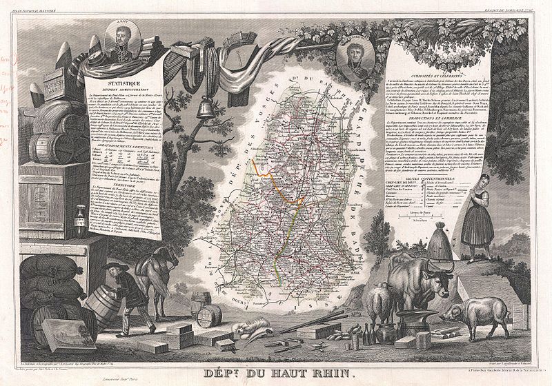
File:1852 Levasseur Map of the Department Du Haut Rhin, France (Alsace Wine Region) - Geographicus - HauteRhin-levasseur-1852.jpg

Size of this preview: 800 × 560 pixels. Other resolutions: 320 × 224 pixels | 640 × 448 pixels | 1,024 × 717 pixels | 1,280 × 896 pixels | 2,560 × 1,792 pixels | 3,500 × 2,450 pixels.
Original file (3,500 × 2,450 pixels, file size: 3.14 MB, MIME type: image/jpeg)
Captions
Captions
Add a one-line explanation of what this file represents
| Dept. du Haut-Rhin. | ||||||||||||||||||||||||||||||||||||
|---|---|---|---|---|---|---|---|---|---|---|---|---|---|---|---|---|---|---|---|---|---|---|---|---|---|---|---|---|---|---|---|---|---|---|---|---|
| Artist |
|
|||||||||||||||||||||||||||||||||||
| Title |
Dept. du Haut-Rhin. |
|||||||||||||||||||||||||||||||||||
| Description |
English: This is a fascinating 1852 map of the French department of Haut-Rhin, France. This mountainous area is part of the Alsace wine region and is known for its production of both Pinot Noir and Pinot Gris. The map proper is surrounded by elaborate decorative engravings designed to illustrate both the natural beauty and trade richness of the land. There is a short textual history of the regions depicted on both the left and right sides of the map. Published by V. Levasseur in the 1852 edition of his Atlas National de la France Illustree. |
|||||||||||||||||||||||||||||||||||
| Date | 1852 (undated) | |||||||||||||||||||||||||||||||||||
| Dimensions | height: 11.5 in (29.2 cm); width: 16.5 in (41.9 cm) | |||||||||||||||||||||||||||||||||||
| Accession number |
Geographicus link: HauteRhin-levasseur-1852 |
|||||||||||||||||||||||||||||||||||
| Source/Photographer |
Levassuer, V., Atlas National Illustre des 86 Departements et des Possessions de La France Divise par Arrondissements, Cantons et Communea avec La Trace de Toutes Les Routes, Chemins,de fer et Canaux., 1852 edition.
|
|||||||||||||||||||||||||||||||||||
| Permission (Reusing this file) |
|
|||||||||||||||||||||||||||||||||||
File history
Click on a date/time to view the file as it appeared at that time.
| Date/Time | Thumbnail | Dimensions | User | Comment | |
|---|---|---|---|---|---|
| current | 05:43, 24 March 2011 | | 3,500 × 2,450 (3.14 MB) | BotMultichillT (talk | contribs) | {{subst:User:Multichill/Geographicus |link=http://www.geographicus.com/P/AntiqueMap/HauteRhin-levasseur-1852 |product_name=1852 Levasseur Map of the Department Du Haut Rhin, France (Alsace Wine Region) |map_title=Dept. du Haut-Rhin. |description=This is a |
You cannot overwrite this file.
File usage on Commons
The following page uses this file:
_-_Geographicus_-_HauteRhin-levasseur-1852.jpg)
File usage on other wikis
The following other wikis use this file:
- Usage on fr.wikipedia.org
- Usage on lb.wikipedia.org
_-_Geographicus_-_HauteRhin-levasseur-1852.jpg&oldid=760471226)