File:1855 Colton Plan or Map of Washington D.C. - Geographicus - WashingtonDC2-colton-1855.jpg
Size of this preview: 730 × 599 pixels. Other resolutions: 292 × 240 pixels | 585 × 480 pixels | 936 × 768 pixels | 1,247 × 1,024 pixels | 2,495 × 2,048 pixels | 4,000 × 3,284 pixels.
Original file (4,000 × 3,284 pixels, file size: 3.51 MB, MIME type: image/jpeg)
Captions
Captions
Add a one-line explanation of what this file represents
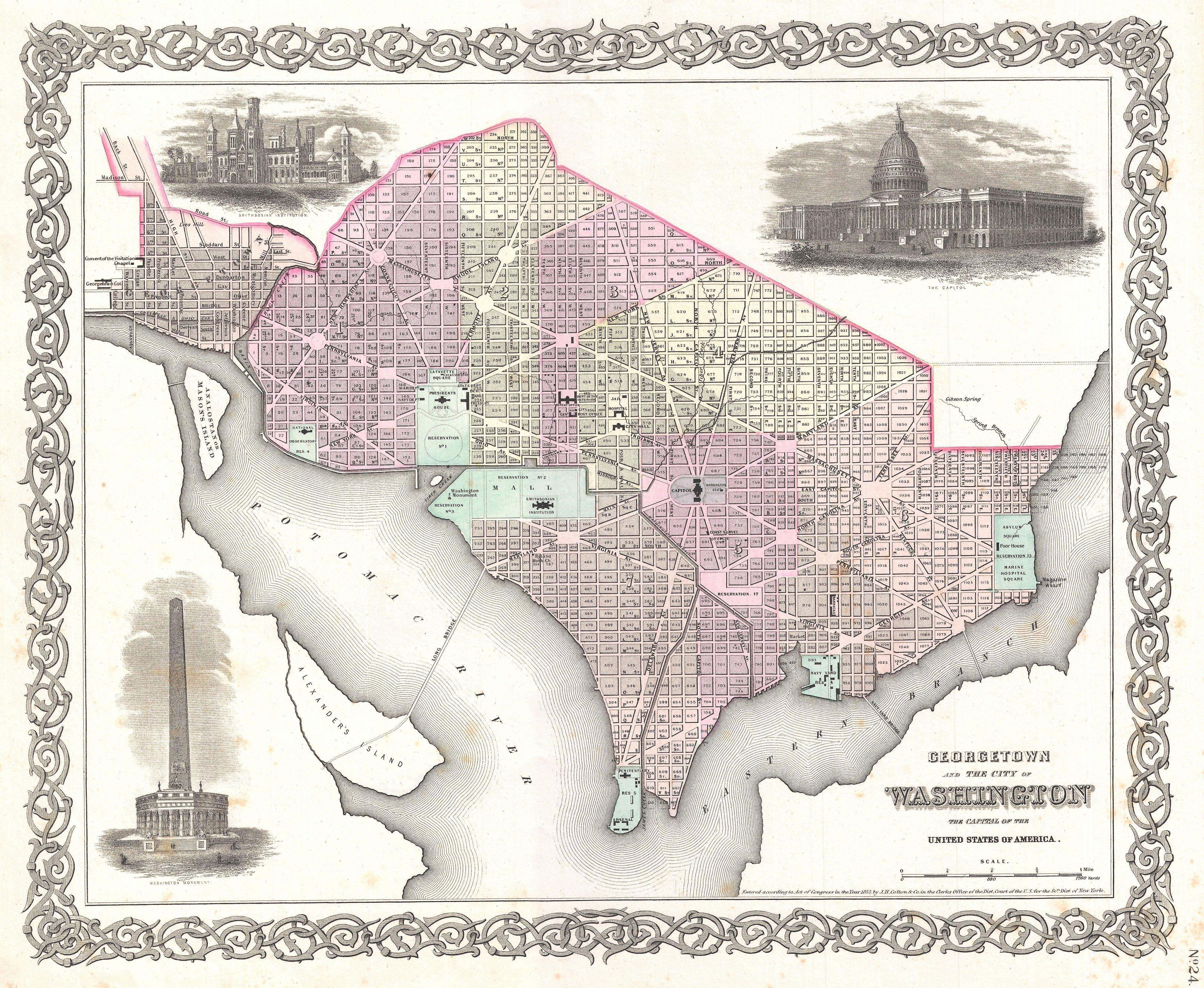
| J. H. Colton: Colton's Georgetown and the City of Washington The Capital of the United States of America.
( |
|||||||||||||||||||||
|---|---|---|---|---|---|---|---|---|---|---|---|---|---|---|---|---|---|---|---|---|---|
| Artist |
|
||||||||||||||||||||
| Title |
Colton's Georgetown and the City of Washington The Capital of the United States of America. |
||||||||||||||||||||
| Description |
English: An excellent 1855 first edition example of Colton's rare map of Washington D.C. and Georgetown. Covers the city in incredible detail from Georgetown (Georgetown University, then College, shown) in the upper left quadrant to Alexander’s Island in the south and as far east as Magazine Warf. Hand colored in pink, green, yellow and blue pastels with considerable detail at level of individual streets and buildings. Surrounded by Colton's typical spiral motif border. Reflects Pierre L'Enfant's brilliant city design, showing the iconic grid and ray street layout. Individual buildings such as the Smithsonian, the White House, the Capitol, the Arsenal, Penitentiary, Naval Yard, Poor House, Asylum, and Post office are all indicated. Features three inset engravings: The Smithsonian Institution, the Capitol, and a preliminary plan for the Washington Monument. Dated and copyrighted to J. H. Colton, 1855. Published as page no. 24 in volume 1 of the first edition of George Washington Colton's 1855 Atlas of the World . |
||||||||||||||||||||
| Date | 1855 (dated) | ||||||||||||||||||||
| Dimensions | height: 13 in (33 cm); width: 16 in (40.6 cm) | ||||||||||||||||||||
| Accession number |
Geographicus link: WashingtonDC2-colton-1855 |
||||||||||||||||||||
| Source/Photographer |
Colton, G. W., Colton's Atlas of the World Illustrating Physical and Political Geography, Vol 1, New York, 1855 (First Edition).
|
||||||||||||||||||||
| Permission (Reusing this file) |
|
||||||||||||||||||||

File history
Click on a date/time to view the file as it appeared at that time.
| Date/Time | Thumbnail | Dimensions | User | Comment | |
|---|---|---|---|---|---|
| current | 10:33, 23 March 2011 | | 4,000 × 3,284 (3.51 MB) | BotMultichillT (talk | contribs) | {{subst:User:Multichill/Geographicus |link=http://www.geographicus.com/P/AntiqueMap/WashingtonDC2-colton-1855 |product_name=1855 Colton Plan or Map of Washington D.C. |map_title=Colton's Georgetown and the City of Washington The Capital of the United Stat |
You cannot overwrite this file.
File usage on Commons
The following page uses this file: