File:1857 Colton Map of Boston, Massachusetts - Geographicus - Boston-colton-1857.jpg

Size of this preview: 517 × 599 pixels. Other resolutions: 207 × 240 pixels | 414 × 480 pixels | 663 × 768 pixels | 884 × 1,024 pixels | 1,768 × 2,048 pixels | 3,021 × 3,500 pixels.
Original file (3,021 × 3,500 pixels, file size: 3.25 MB, MIME type: image/jpeg)
Captions
Captions
Add a one-line explanation of what this file represents
| J. H. Colton: Map of Boston and Adjacent Cities.
( |
|||||||||||||||||||||
|---|---|---|---|---|---|---|---|---|---|---|---|---|---|---|---|---|---|---|---|---|---|
| Artist |
|
||||||||||||||||||||
| Title |
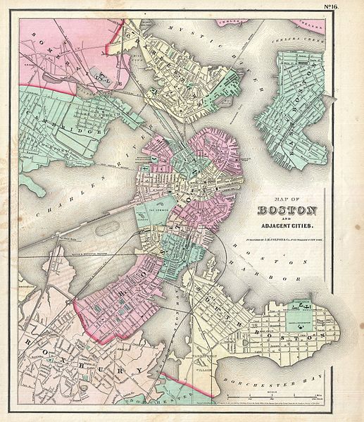
Map of Boston and Adjacent Cities. |
||||||||||||||||||||
| Description |
English: An excellent 1857 example of Colton's map of Boston, Massachusetts. Includes the surrounding communities of Cambridge, Summerville, Charleston, East Boston, South Boston and Roxbury. Hand colored in pink, green, yellow and blue pastels with considerable detail at level of individual streets and buildings. This is an exceptionally interesting and important map of Boston issued just prior to the Back Bay land reclamation projection. The street and avenue grid is ghosted-in in anticipation of this enormous urban development project. Modern residents of the Back Bay may still recognize the Mill Dam (Beacon Street) and the railroad crossings. The rest of this projection, with its large oval pond, may be more confusing. This layout is based on the real estate ambitions of David Sears, who acquired much of this property in anticipation of the impending land fill. He believed the lake, which never materialized, would make adjacent properties more desirable. Dated and copyrighted to J. H. Colton, 1855. Published as page no. 16 in the 1857 edition of George Washington Colton's Atlas of the World . This was the first edition of Colton's atlas in which the maps were printed without Colton's trademark spiral motif border design. |
||||||||||||||||||||
| Date | 1857 (dated 1855) | ||||||||||||||||||||
| Dimensions | height: 15 in (38.1 cm); width: 12.5 in (31.7 cm) | ||||||||||||||||||||
| Accession number |
Geographicus link: Boston-colton-1857 |
||||||||||||||||||||
| Source/Photographer |
Colton, G. W., Colton's Atlas of the World Illustrating Physical and Political Geography, New York, 1857.
|
||||||||||||||||||||
| Permission (Reusing this file) |
|
||||||||||||||||||||

File history
Click on a date/time to view the file as it appeared at that time.
| Date/Time | Thumbnail | Dimensions | User | Comment | |
|---|---|---|---|---|---|
| current | 17:19, 23 March 2011 | | 3,021 × 3,500 (3.25 MB) | BotMultichillT (talk | contribs) | {{subst:User:Multichill/Geographicus |link=http://www.geographicus.com/P/AntiqueMap/Boston-colton-1857 |product_name=1857 Colton Map of Boston, Massachusetts |map_title=Map of Boston and Adjacent Cities. |description=An excellent 1857 example of Colton's |
You cannot overwrite this file.
File usage on Commons
The following page uses this file: