File:1857 U.S. Coast Survey Map of the Eastern Entrance to Santa Barbara Channel - Geographicus - SantaBarbaraChanne-uscs-1857.jpg

Size of this preview: 800 × 566 pixels. Other resolutions: 320 × 226 pixels | 640 × 452 pixels | 1,024 × 724 pixels | 1,280 × 905 pixels | 2,560 × 1,810 pixels | 5,000 × 3,535 pixels.
Original file (5,000 × 3,535 pixels, file size: 4.2 MB, MIME type: image/jpeg)
Captions
Captions
Add a one-line explanation of what this file represents
| Preliminary Chart of Eastern Entrance to Santa Barbara Channel Claifornia. | ||||||
|---|---|---|---|---|---|---|
| Artist | ||||||
| Title |
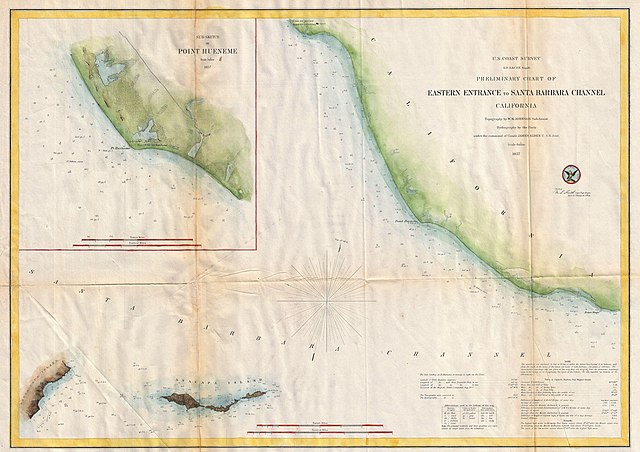
Preliminary Chart of Eastern Entrance to Santa Barbara Channel Claifornia. |
|||||
| Description |
English: An extremely attractive hand colored 1857 U.S. Coast Survey chart or map of the Eastern Entrance to Santa Barbara Channel. Depicts the California coast from the Town and Mission of San Buenaventura (Ventura, CA) to Point Mugu. Includes Santa Cruz Island and Anacapa Island. An inset map in the upper left quadrant details Point Hueneme (Port Hueneme) and its vicinity. The entire map offers numerous depth soundings. Detailed information on Tides and Sailing instructions in the lower right quadrant. The topography for the map was prepared by W. M. Johnson. The hydrography was accomplished by a party under the command of James Alden. Compiled under the direction of A. D. Bache, Superintendent of the Survey of the Coast of the United States and one of the most influential American cartographers of the 19th century. |
|||||
| Date | 1857 (dated) | |||||
| Dimensions | height: 16.6 in (42.1 cm); width: 23.5 in (59.6 cm) | |||||
| Accession number |
Geographicus link: SantaBarbaraChanne-uscs-1857 |
|||||
| Source/Photographer |
Report of the Superintendant of the U.S. Coast Survey, (1857 edition).
|
|||||
| Permission (Reusing this file) |
|
|||||
| Object location | | View this and other nearby images on: OpenStreetMap |
|---|
File history
Click on a date/time to view the file as it appeared at that time.
| Date/Time | Thumbnail | Dimensions | User | Comment | |
|---|---|---|---|---|---|
| current | 14:29, 22 March 2011 | | 5,000 × 3,535 (4.2 MB) | BotMultichillT (talk | contribs) | {{subst:User:Multichill/Geographicus |link=http://www.geographicus.com/P/AntiqueMap/SantaBarbaraChanne-uscs-1857 |product_name=1857 U.S. Coast Survey Map of the Eastern Entrance to Santa Barbara Channel |map_title=Preliminary Chart of Eastern Entrance to |
You cannot overwrite this file.
File usage on Commons
The following page uses this file:
File usage on other wikis
The following other wikis use this file:
- Usage on de.wikipedia.org
- Usage on en.wikipedia.org