File:1859 U.S. Coast Survey Map or Nautical Chart of Crescent City, California - Geographicus - CrescentCityCalifornia-uscs-1859.jpg
Original file (3,500 × 2,697 pixels, file size: 1.76 MB, MIME type: image/jpeg)
Captions
Captions
Summary edit
| Crescent City Harbor California. | ||||
|---|---|---|---|---|
| Artist | ||||
| Title |
Crescent City Harbor California. |
|||
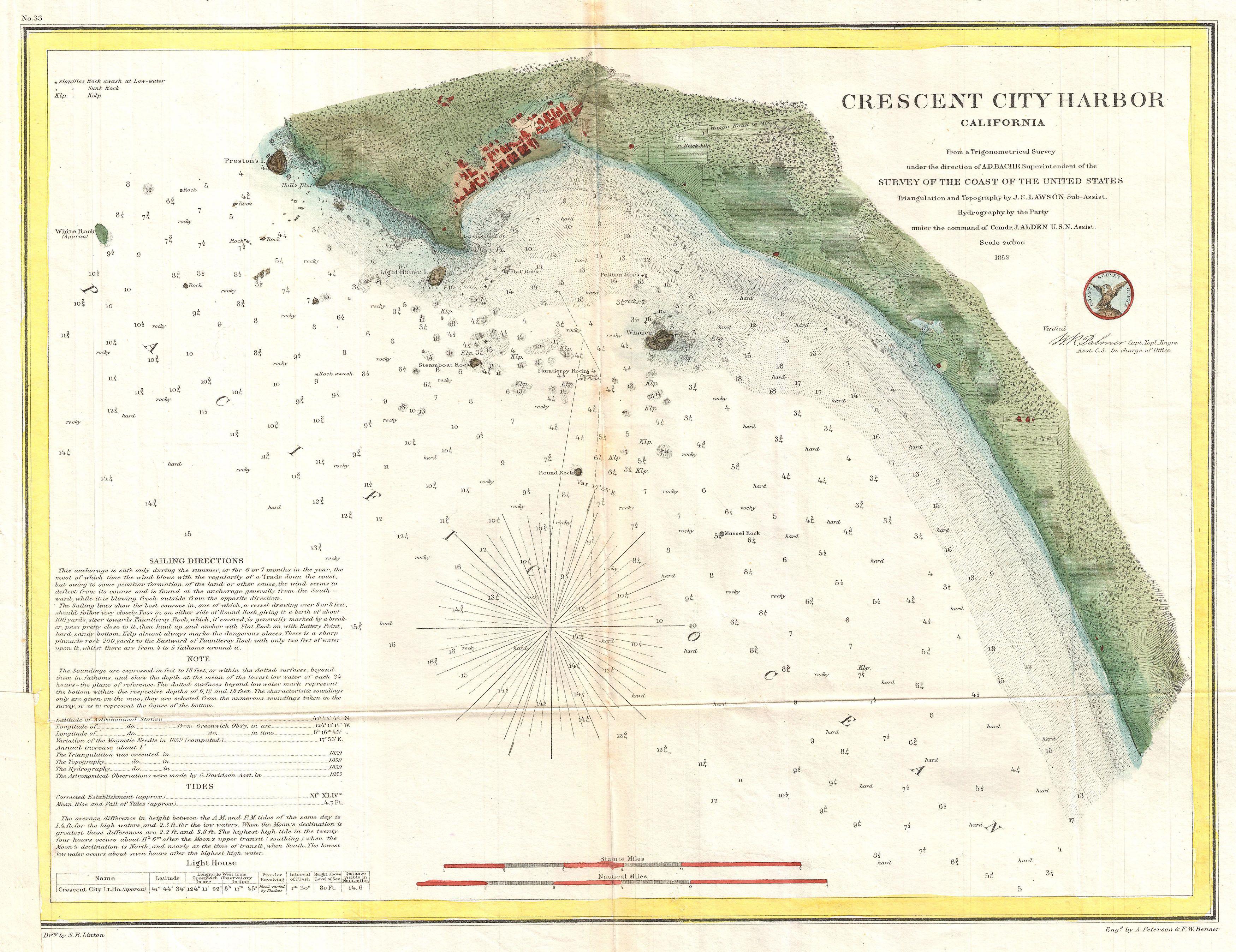
| Description |
English: A very attractive example of the rare 1859 U.S. Coast Survey map or nautical chart of Crescent City Harbor, California. Crescent City is California’s northernmost harbor and is located along the state’s stunning Redwood Coast. This map covers the Harbor as well as Crescent City itself from Preston’s Island south. Sailing directions appear in the lower left quadrant. The triangulation and topography for this map was completed by J. F. Lawson. The Hydrography was accomplished by a party under the command of J. Alden. The whole was completed under the direction of A. D. Bache, one of the most influential and prolific Superintendents of the U.S. Coast Survey. Published in the 1859 edition of the Superintendent’s Report to congress. |
|||
| Date | 1859 (dated) | |||
| Dimensions | height: 12 in (30.4 cm); width: 16 in (40.6 cm) | |||
| Accession number |
Geographicus link: CrescentCityCalifornia-uscs-1859 |
|||
| Source/Photographer |
Report of the Superintendent of the United States Coast Survey, (Washington D.C.) 1859.
|
|||
| Permission (Reusing this file) |
|
|||

File history
Click on a date/time to view the file as it appeared at that time.
| Date/Time | Thumbnail | Dimensions | User | Comment | |
|---|---|---|---|---|---|
| current | 07:30, 25 March 2011 | | 3,500 × 2,697 (1.76 MB) | BotMultichillT (talk | contribs) | {{subst:User:Multichill/Geographicus |link=http://www.geographicus.com/P/AntiqueMap/CrescentCityCalifornia-uscs-1859 |product_name=1859 U.S. Coast Survey Map or Nautical Chart of Crescent City, California |map_title=Crescent City Harbor California. |descr |
You cannot overwrite this file.
File usage on Commons
The following page uses this file: