File:1862 Colton Pocket Map of the United States ( Civil War ) - Geographicus - UnitedStates-colton-1862.jpg
Size of this preview: 711 × 600 pixels. Other resolutions: 285 × 240 pixels | 569 × 480 pixels | 910 × 768 pixels | 1,214 × 1,024 pixels | 2,427 × 2,048 pixels | 4,500 × 3,797 pixels.
Original file (4,500 × 3,797 pixels, file size: 6.65 MB, MIME type: image/jpeg)
Captions
Captions
Add a one-line explanation of what this file represents
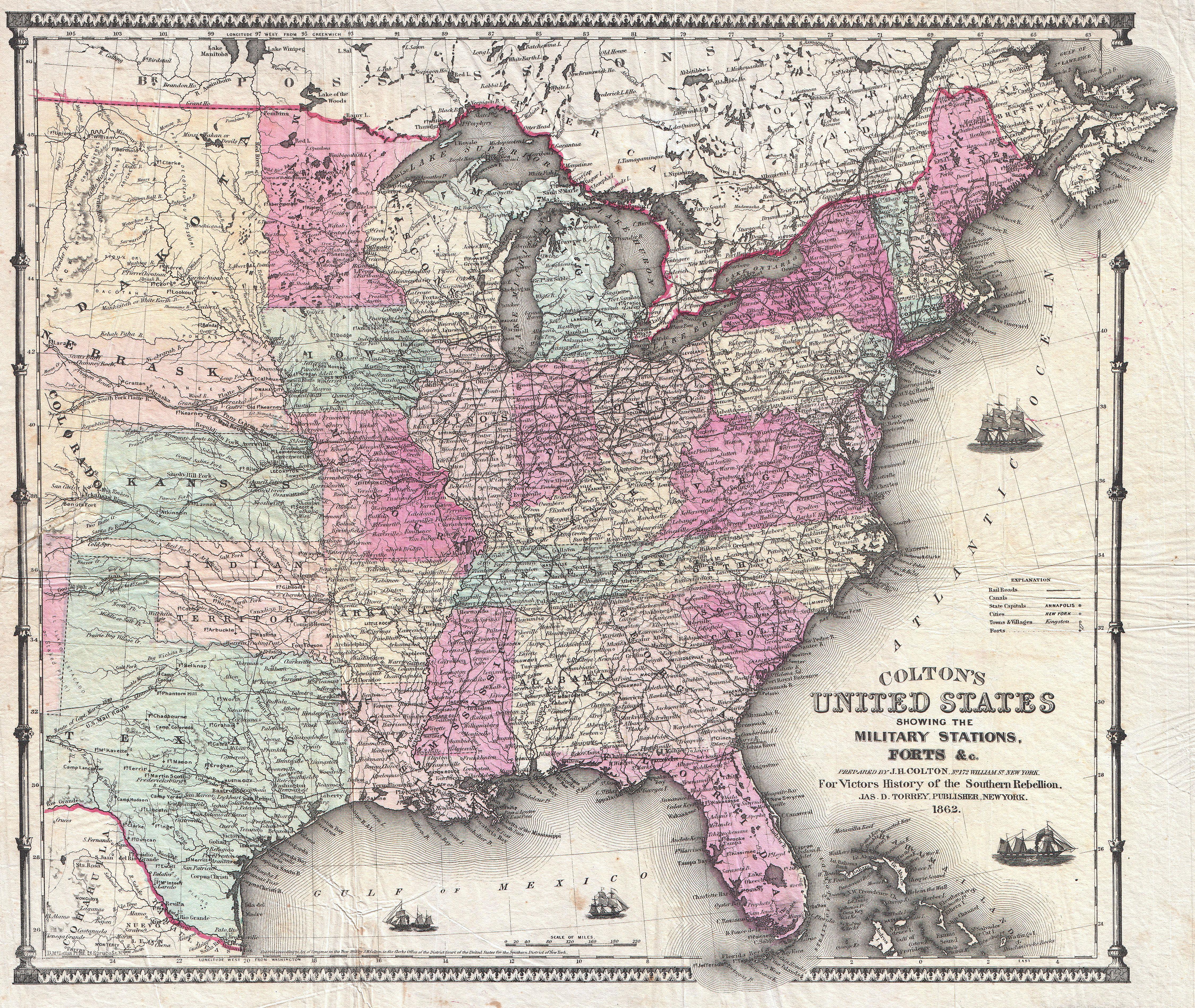
| J. H. Colton: Colton’s United States showing the Military Stations, Forts & co.
( |
|||||||||||||||||||||
|---|---|---|---|---|---|---|---|---|---|---|---|---|---|---|---|---|---|---|---|---|---|
| Artist |
|
||||||||||||||||||||
| Title |
Colton’s United States showing the Military Stations, Forts & co. |
||||||||||||||||||||
| Description |
English: A scarce and extremely attractive pocket map of the United States by J. H. Colton. This map was issued in 1862, in the midst of the Civil War, for inclusion in Victor’s History of the Southern Rebellion . Depicts the United States as far west as Texas and Colorado. Features a distended Nebraska, no Wyoming, and a large Dakota Territory. Virginia is undivided. Extends south as far as the Bahamas and the Florida Keys. Shows the Pony Express Route, the U.S. Mail Route, and the tracks of various Civil War military campaigns. Forts are indicated with little flags. Four sailing/steam ships decorate the seas. An attractive decorative border surrounds the map. Colton based this map, with updates to reflect the changes of the Civil War, on the 1855 Map of the United States that appeared in his 1855 issue of Colton’s Atlas of the World . Dated and copyrighted: “Entered according to the Act of Congress in the Year of 1855 by J. H. Colton & Co. in the Clerk’s Office of the District Court of the United States for the Southern District of New York.” Published from Colton’s 172 William Str. Office in New York City. Exceedingly rare. |
||||||||||||||||||||
| Date | 1862 (dated) | ||||||||||||||||||||
| Dimensions | height: 15 in (38.1 cm); width: 17 in (43.1 cm) | ||||||||||||||||||||
| Accession number |
Geographicus link: UnitedStates-colton-1862 |
||||||||||||||||||||
| Source/Photographer |
Victor, Orville J., The History, Civil, Political and Military of the Southern Rebellion. (1862 edition)
|
||||||||||||||||||||
| Permission (Reusing this file) |
|
||||||||||||||||||||

File history
Click on a date/time to view the file as it appeared at that time.
| Date/Time | Thumbnail | Dimensions | User | Comment | |
|---|---|---|---|---|---|
| current | 23:07, 24 March 2011 | | 4,500 × 3,797 (6.65 MB) | BotMultichillT (talk | contribs) | {{subst:User:Multichill/Geographicus |link=http://www.geographicus.com/P/AntiqueMap/UnitedStates-colton-1862 |product_name=1862 Colton Pocket Map of the United States ( Civil War ) |map_title=Colton’s United States showing the Military Stations, Forts & |
You cannot overwrite this file.
File usage on Commons
The following page uses this file:
_-_Geographicus_-_UnitedStates-colton-1862.jpg)
_-_Geographicus_-_UnitedStates-colton-1862.jpg&oldid=745868586)