File:1862 Johnson Map of Spain and Portugal - Geographicus - SpainPortugal-j-62.jpg

Original file (3,000 × 2,404 pixels, file size: 2.43 MB, MIME type: image/jpeg)
Captions
Captions
| Johnson's Spain and Portugal. | ||||||
|---|---|---|---|---|---|---|
| Title |
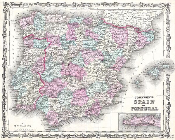
Johnson's Spain and Portugal. |
|||||
| Description |
English: This is Johnson and Ward’s 1862 map of Spain and Portugal. Covers the region with particular attention to transportation, cities, and waterways. Lower right hand quadrant has an inset map of Gibraltar. Includes the Balearic Island of Ibiza, Majorca and Minorca. Features the ribbon style border common to Johnson’s atlas work from 1860 to 1862. Steel plate engraving prepared by A. J. Johnson for publication as plate no. 75 in the 1862 edition of his New Illustrated Atlas… This is the first edition of the Johnson’s Atlas to bear the Johnson and Ward imprint. |
|||||
| Date | 1862 (undated) | |||||
| Dimensions | height: 12.5 in (31.7 cm); width: 16 in (40.6 cm) | |||||
| Accession number |
Geographicus link: SpainPortugal-j-62 |
|||||
| Source/Photographer |
Johnson, A. J., Johnson's New Illustrated (Steel Plate) Family Atlas with Descriptions, Geographical, Statistical, and Historical. (1862 A. J. Johnson & Ward edition)
|
|||||
| Permission (Reusing this file) |
|
|||||
| Other versions | ||||||
.jpg)
File history
Click on a date/time to view the file as it appeared at that time.
| Date/Time | Thumbnail | Dimensions | User | Comment | |
|---|---|---|---|---|---|
| current | 21:08, 11 March 2011 | | 3,000 × 2,404 (2.43 MB) | BotMultichill (talk | contribs) | {{subst:User:Multichill/Geographicus |link=http://www.geographicus.com/P/AntiqueMap/SpainPortugal-j-62 |product_name=1862 Johnson Map of Spain and Portugal |map_title=Johnson's Spain and Portugal. |description=This is Johnson and Ward’s 1862 map of Spai |
You cannot overwrite this file.
File usage on Commons
The following 7 pages use this file:
- Commons:Geographicus
- Commons:Geographicus/de
- Commons:Geographicus/fr
- Commons:Geographicus/mk
- Commons:Geographicus/sample
- File:1862 Johnson Map of Spain and Portugal - Geographicus - SpainPortugal-j-62.jpg
- File:Catalonia. 1862 Johnson Map of Spain and Portugal - Geographicus - SpainPortugal-j-62 (cropped).jpg
File usage on other wikis
The following other wikis use this file:
- Usage on en.wikipedia.org