File:1863 Johnson Map of Austria, Hungary, Turkey, Italy and Greece - Geographicus - AustriaTurkey-johnson-1862.jpg

Size of this preview: 800 × 575 pixels. Other resolutions: 320 × 230 pixels | 640 × 460 pixels | 1,024 × 736 pixels | 1,280 × 920 pixels | 2,560 × 1,839 pixels | 5,000 × 3,592 pixels.
Original file (5,000 × 3,592 pixels, file size: 6.57 MB, MIME type: image/jpeg)
Captions
Captions
Add a one-line explanation of what this file represents
| Alvin Jewett Johnson: Johnson's Austria, Turkey in Europe and Greece.
( |
|||||||||||||||||||||||
|---|---|---|---|---|---|---|---|---|---|---|---|---|---|---|---|---|---|---|---|---|---|---|---|
| Artist |
|
||||||||||||||||||||||
| Title |
Johnson's Austria, Turkey in Europe and Greece. |
||||||||||||||||||||||
| Description |
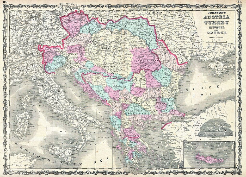
English: This is A. J. Johnson and Ward’s 1863 map of Austria, Turkey in Europe and Greece. Covers from Italy eastward to include all of Austria, Hungary, the Balkans (Bosnia, Serbia, Albania, Croatia, Macedonia, Bulgaria, Rumania, etc.), Greece and parts of Turkey. Color coded by district. Shows major roadways, cities, rivers, trains and ferry crossings. Lower right quadrant offers a view of the Mosque of St. Sophia in Istanbul. Features the strapwork border common to Johnson’s atlas work from 1860 to 1863. Steel plate engraving prepared by A. J. Johnson for publication as page nos. 85-86 in the 1863 edition of his New Illustrated Atlas… This is the first edition of the Johnson’s Atlas to bear the Johnson and Ward imprint. |
||||||||||||||||||||||
| Date | 1863 (undated) | ||||||||||||||||||||||
| Dimensions | height: 17.5 in (44.4 cm); width: 24 in (60.9 cm) | ||||||||||||||||||||||
| Accession number |
Geographicus link: AustriaTurkey-johnson-1862 |
||||||||||||||||||||||
| Source/Photographer |
Johnson, A. J., Johnson's New Illustrated Family Atlas. (1863 A. J. Johnson & Ward edition)
|
||||||||||||||||||||||
| Permission (Reusing this file) |
|
||||||||||||||||||||||
File history
Click on a date/time to view the file as it appeared at that time.
| Date/Time | Thumbnail | Dimensions | User | Comment | |
|---|---|---|---|---|---|
| current | 21:06, 21 March 2011 | | 5,000 × 3,592 (6.57 MB) | BotMultichill (talk | contribs) | {{subst:User:Multichill/Geographicus |link=http://www.geographicus.com/P/AntiqueMap/AustriaTurkey-johnson-1862 |product_name=1863 Johnson Map of Austria, Hungary, Turkey, Italy and Greece |map_title=Johnson's Austria, Turkey in Europe and Greece. |descrip |
You cannot overwrite this file.
File usage on Commons
The following page uses this file:
File usage on other wikis
The following other wikis use this file: