File:1864 Johnson Map of Africa - Geographicus - Africa-johnson-1864.jpg
Size of this preview: 447 × 600 pixels. Other resolutions: 179 × 240 pixels | 358 × 480 pixels | 572 × 768 pixels | 763 × 1,024 pixels | 1,527 × 2,048 pixels | 2,982 × 4,000 pixels.
Original file (2,982 × 4,000 pixels, file size: 3.73 MB, MIME type: image/jpeg)
Captions
Captions
Add a one-line explanation of what this file represents
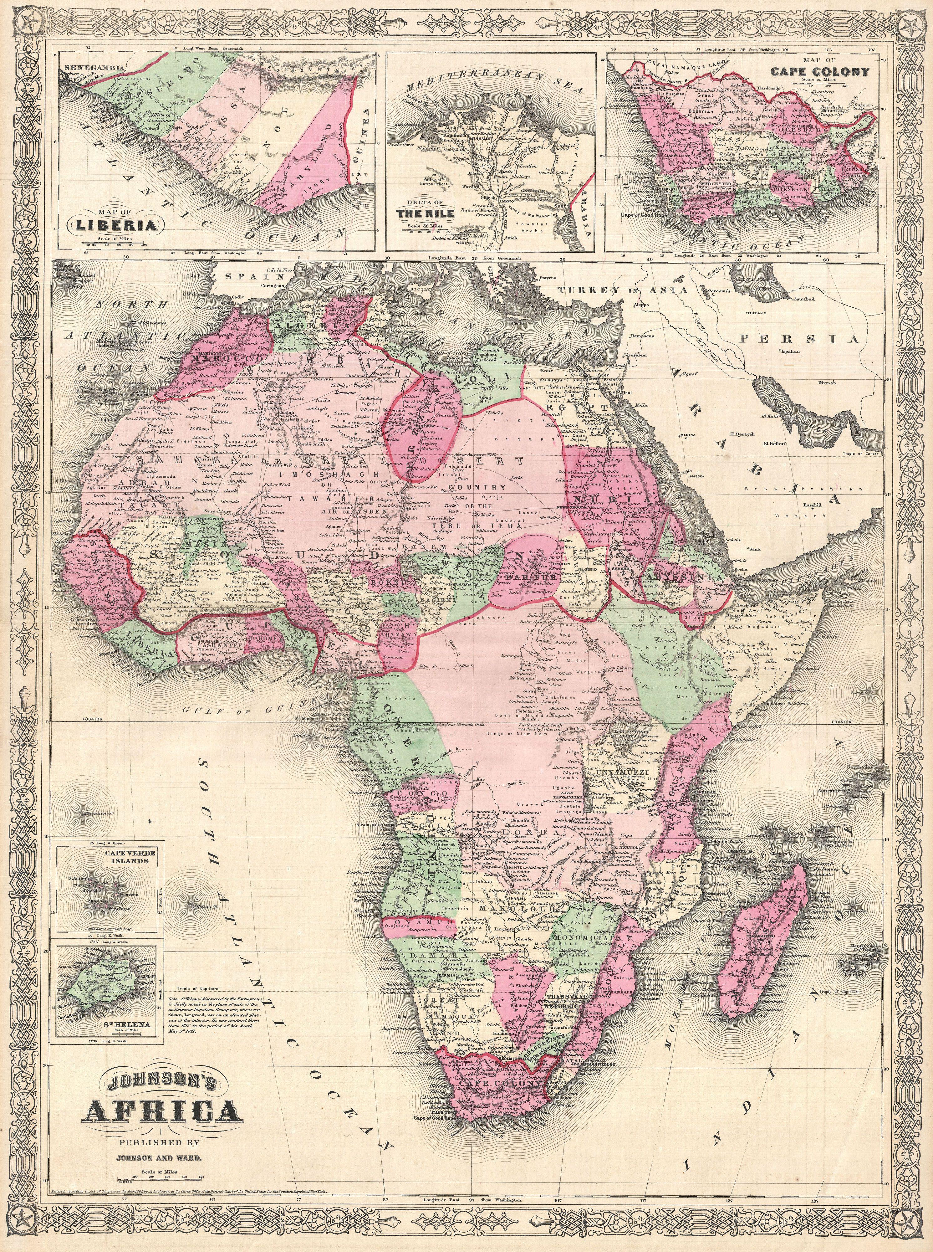
| Alvin Jewett Johnson: Johnson's Africa.
( |
|||||||||||||||||||||||
|---|---|---|---|---|---|---|---|---|---|---|---|---|---|---|---|---|---|---|---|---|---|---|---|
| Artist |
|
||||||||||||||||||||||
| Title |
Johnson's Africa. |
||||||||||||||||||||||
| Description |
English: A beautiful first edition example of A. J. Johnson’s highly decorative 1864 map of Africa. The map covers the entire African continent as well as adjacent parts of Arabia and the Mediterranean. Throughout, Johnson identifies various cities, towns, rivers and assortment of additional topographical details. Johnson introduced this map in 1864 to replace the more primitive Colton mapping of Africa used in his earlier atlases. This map accommodates recent discoveries and explorations in Africa. It is consequently the first of Johnson’s Africa series to accurately represent Lake Victoria and Mt. Kilimanjaro. Features the fretwork style border common to Johnson’s atlas work from 1864 to 1869. Published by A. J. Johnson and Ward as plates 99-100 in the 1864 edition of Johnson’s New Illustrated Family Atlas . This is the first edition of the Johnson’s Atlas to bear the Johnson & Ward imprint and the only edition to identify the firm as the “Successors to Johnson and Browning (Successors to J. H. Colton and Company)”. Dated and copyrighted, “Entered according to Act of Congress in the Year 1864 by A. J. Johnson in the Clerks Office of the District Court of the United States for the Southern District of New York. |
||||||||||||||||||||||
| Date | 1864 (dated 1864) | ||||||||||||||||||||||
| Dimensions | height: 23.5 in (59.6 cm); width: 17.5 in (44.4 cm) | ||||||||||||||||||||||
| Accession number |
Geographicus link: Africa-johnson-1864 |
||||||||||||||||||||||
| Source/Photographer |
Johnson, A. J., Johnson's New Illustrated (Steel Plate) Family Atlas of The World with Physical Geography, and with Descriptions Geographical, Statistical, and Historic including The Latest Federal Census, A Geographical Index, and a Chronological History of the Civil War in America, (first Johnson and Ward), 1864.
|
||||||||||||||||||||||
| Permission (Reusing this file) |
|
||||||||||||||||||||||
File history
Click on a date/time to view the file as it appeared at that time.
| Date/Time | Thumbnail | Dimensions | User | Comment | |
|---|---|---|---|---|---|
| current | 01:29, 25 March 2011 | | 2,982 × 4,000 (3.73 MB) | BotMultichillT (talk | contribs) | {{subst:User:Multichill/Geographicus |link=http://www.geographicus.com/P/AntiqueMap/Africa-johnson-1864 |product_name=1864 Johnson Map of Africa |map_title=Johnson's Africa. |description=A beautiful first edition example of A. J. Johnson’s highly decora |
You cannot overwrite this file.
File usage on Commons
The following page uses this file:
File usage on other wikis
The following other wikis use this file:
- Usage on de.wikipedia.org