File:1865 Johnson Map of New York City and Brooklyn - Geographicus - NewYorkCity-johnson-1865.jpg

Size of this preview: 800 × 515 pixels. Other resolutions: 320 × 206 pixels | 640 × 412 pixels | 1,024 × 659 pixels | 1,280 × 823 pixels | 2,560 × 1,647 pixels | 4,000 × 2,573 pixels.
Original file (4,000 × 2,573 pixels, file size: 3.29 MB, MIME type: image/jpeg)
Captions
Captions
Add a one-line explanation of what this file represents
| Alvin Jewett Johnson: Johnson's Map of New York and the Adjacent Cities.
( |
|||||||||||||||||||||||
|---|---|---|---|---|---|---|---|---|---|---|---|---|---|---|---|---|---|---|---|---|---|---|---|
| Artist |
|
||||||||||||||||||||||
| Title |
Johnson's Map of New York and the Adjacent Cities. |
||||||||||||||||||||||
| Description |
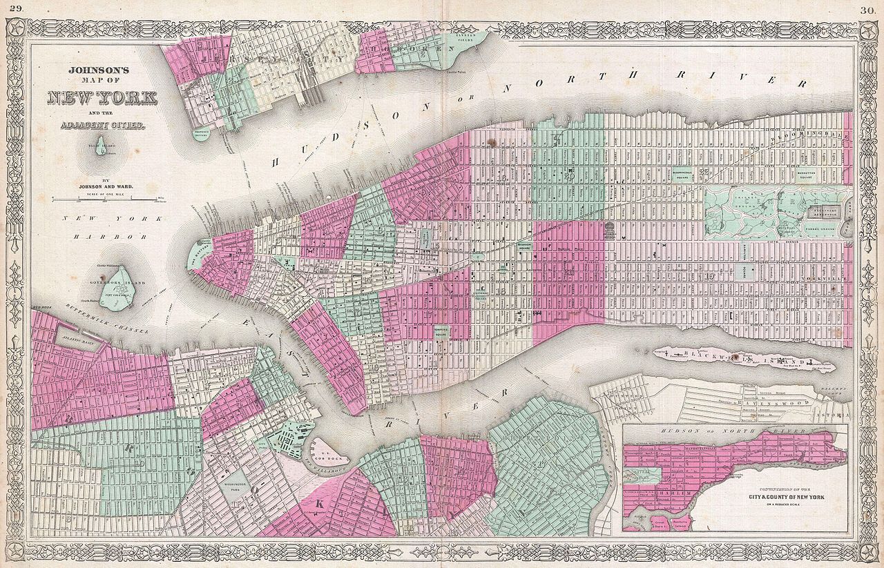
English: A fine hand colored map of New York City and Brooklyn dating to 1865. Covers the island of Manhattan and the borough of Brooklyn as well as parts of Jersey City and Hoboken. Johnson's plan is heavily based upon the third state of J. H. Colton's New York City atlas map. Central Park is shown in great detail and in and earlier incarnation than we know today with the Receiving Reservoir in the place of today’s Great Lawn. The important ferries running between New York, Brooklyn, Queens, and New Jersey, are all noted. In Queens we can see the newly built Long Island Railroad leaving Flushing station at Hunter's Point. At the tip of Roosevelt Island where now stands a decrepit ruin, there Johnson notes a civil war hospital. Represents Page no. 29 - 30 in the 1865 Johnson and Ward edition of Johnson’s Family Atlas . This is the last edition of this map to bear the Johnson and Ward imprint. |
||||||||||||||||||||||
| Date | 1865 (undated) | ||||||||||||||||||||||
| Dimensions | height: 16.5 in (41.9 cm); width: 25 in (63.5 cm) | ||||||||||||||||||||||
| Accession number |
Geographicus link: NewYorkCity-johnson-1865 |
||||||||||||||||||||||
| Source/Photographer |
Johnson, A. J., Johnson's New Illustrated Family Atlas with Descriptions, Geographical, Statistical, and Historical. (1865 A. J. Johnson and Ward edition)
|
||||||||||||||||||||||
| Permission (Reusing this file) |
|
||||||||||||||||||||||
File history
Click on a date/time to view the file as it appeared at that time.
| Date/Time | Thumbnail | Dimensions | User | Comment | |
|---|---|---|---|---|---|
| current | 16:17, 23 March 2011 | | 4,000 × 2,573 (3.29 MB) | BotMultichillT (talk | contribs) | {{subst:User:Multichill/Geographicus |link=http://www.geographicus.com/P/AntiqueMap/NewYorkCity-johnson-1865 |product_name=1865 Johnson Map of New York City and Brooklyn |map_title=Johnson's Map of New York and the Adjacent Cities. |description=A fine han |
You cannot overwrite this file.
File usage on Commons
The following page uses this file: