File:1865 Spruner Map of Spain and Portugal - Geographicus - Hispania-spruner-1865.jpg
Size of this preview: 742 × 599 pixels. Other resolutions: 297 × 240 pixels | 594 × 480 pixels | 951 × 768 pixels | 1,268 × 1,024 pixels | 2,536 × 2,048 pixels | 3,500 × 2,827 pixels.
Original file (3,500 × 2,827 pixels, file size: 2.52 MB, MIME type: image/jpeg)
Captions
Captions
Add a one-line explanation of what this file represents
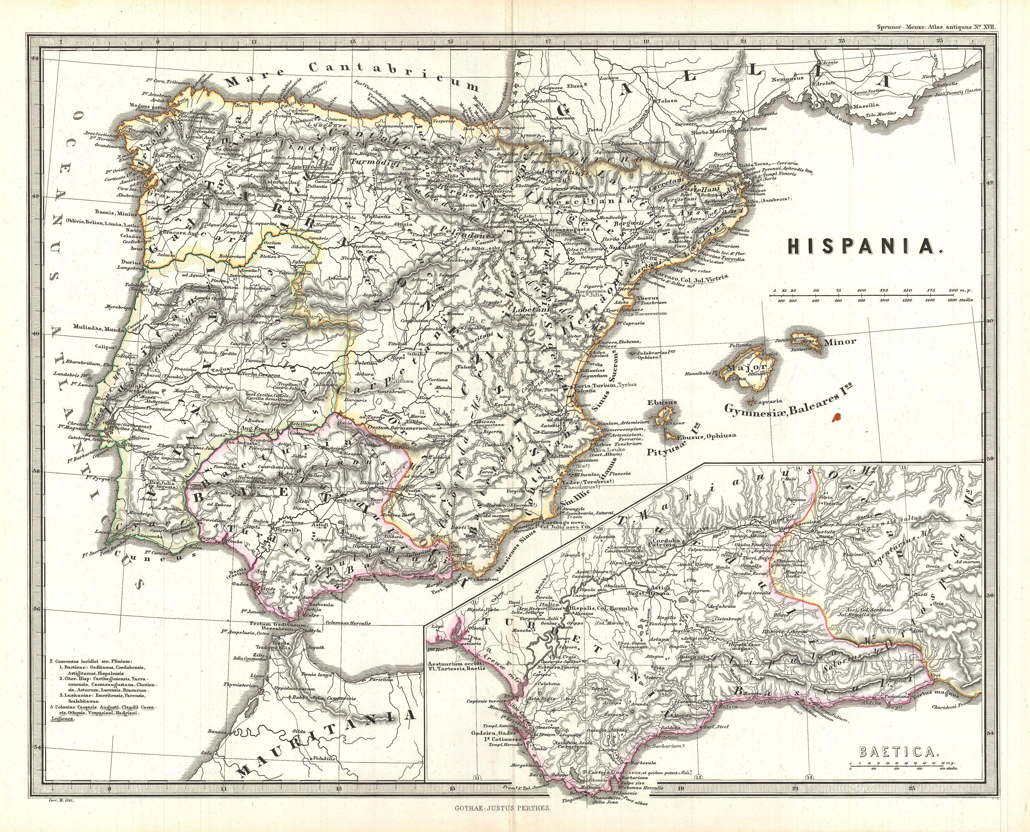
| Karl Spruner von Merz: Hispania.
( |
||||||||||||||||||||
|---|---|---|---|---|---|---|---|---|---|---|---|---|---|---|---|---|---|---|---|---|
| Artist |
|
|||||||||||||||||||
| Title |
Hispania. |
|||||||||||||||||||
| Description |
English: This is Karl von Spruner’s 1865 map of Hispania (modern day Spain and Portugal). Under the Roman Republic, Hispania or Iberia was divided into two provinces: Hispania Citerior and Hispania Ulterior –both of which are noted here. Later, during the Roman Principate, Hispania Ulterior was divided into two new provinces, Baetica and Lusitania, while Hispania Citerior was renamed Tarraconensis, which is illustrated on this map. Spruner also includes a detailed inset, showing Hispania Baetica (modern day Andalucía), one of three Imperial Roman provinces in Hispania, (modern Iberia). Hispania Baetica was bordered to the west by Lusitania, and to the northeast by Hispania Tarraconensis. Shows names of ancient tribes and peoples and the areas they inhabited. Map includes a scale and a legend in the upper-left quadrant. Map notes important cities, rivers, mountain ranges and other minor topographical detail. Territories and countries outlined in color. The whole is rendered in finely engraved detail exhibiting throughout the fine craftsmanship of the Perthes firm. |
|||||||||||||||||||
| Date | 1865 (undated) | |||||||||||||||||||
| Dimensions | height: 13 in (33 cm); width: 16 in (40.6 cm) | |||||||||||||||||||
| Accession number |
Geographicus link: Hispania-spruner-1865 |
|||||||||||||||||||
| Source/Photographer |
Spruner, Karl von, Spruner-Menke Atlas Antiquus,, (Gotha: Justus Perthes), 1865.
|
|||||||||||||||||||
| Permission (Reusing this file) |
|
|||||||||||||||||||
File history
Click on a date/time to view the file as it appeared at that time.
| Date/Time | Thumbnail | Dimensions | User | Comment | |
|---|---|---|---|---|---|
| current | 06:00, 25 March 2011 | | 3,500 × 2,827 (2.52 MB) | BotMultichillT (talk | contribs) | {{subst:User:Multichill/Geographicus |link=http://www.geographicus.com/P/AntiqueMap/Hispania-spruner-1865 |product_name=1865 Spruner Map of Spain and Portugal |map_title=Hispania. |description=This is Karl von Spruner’s 1865 map of Hispania (modern day |
You cannot overwrite this file.
File usage on Commons
The following page uses this file: