File:1866 Mitchell Map of the World on Mercator Projection - Geographicus - WorldMercator-mitchell-1866.jpg
Size of this preview: 751 × 600 pixels. Other resolutions: 301 × 240 pixels | 601 × 480 pixels | 962 × 768 pixels | 1,280 × 1,022 pixels | 2,560 × 2,045 pixels | 4,000 × 3,195 pixels.
Original file (4,000 × 3,195 pixels, file size: 4.15 MB, MIME type: image/jpeg)
Captions
Captions
Add a one-line explanation of what this file represents
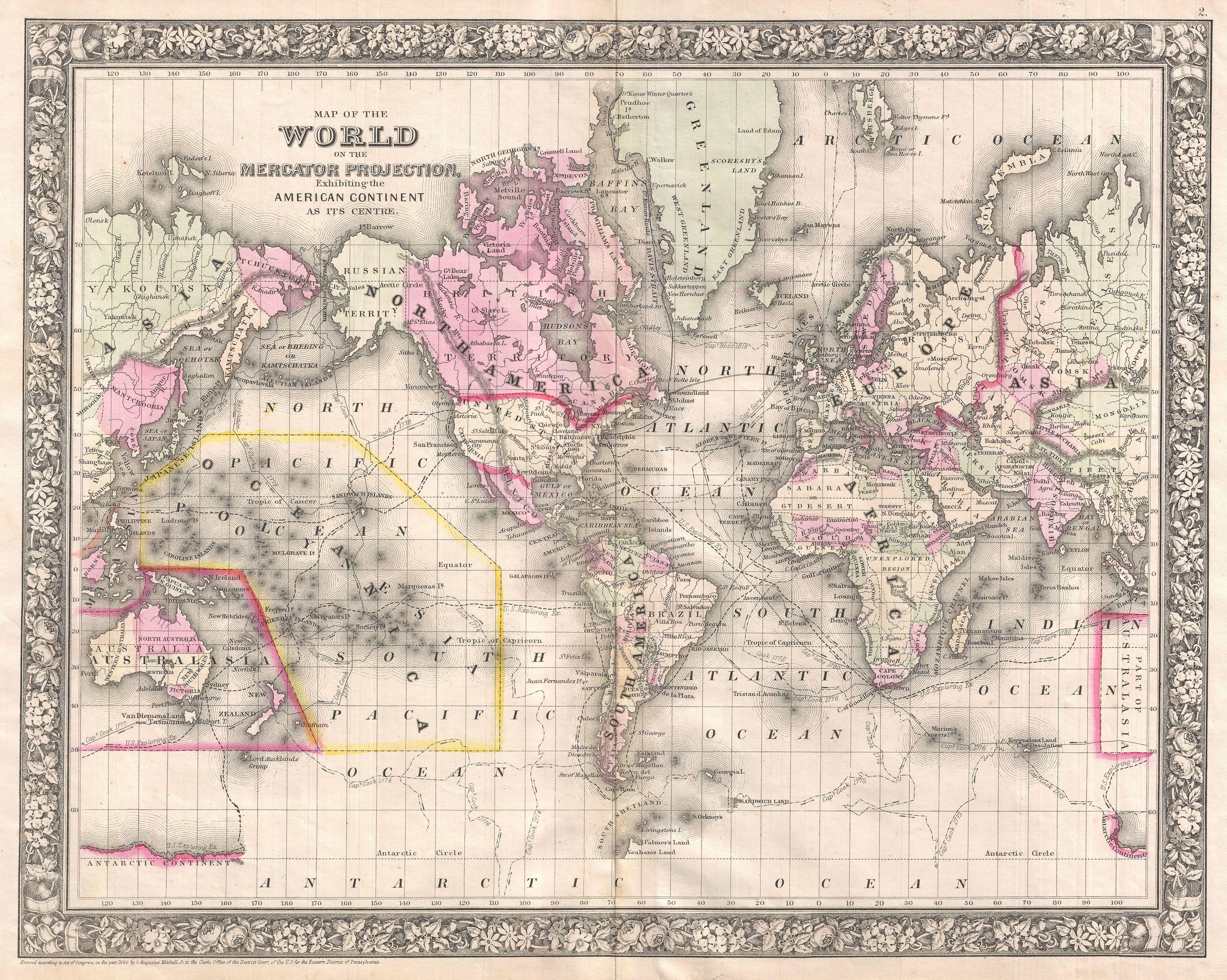
| Samuel Augustus Mitchell: Map of the World on the Mercator Projection, Exhibiting the American Continent at its Centre.
( |
||||||||||||||||||||
|---|---|---|---|---|---|---|---|---|---|---|---|---|---|---|---|---|---|---|---|---|
| Artist |
|
|||||||||||||||||||
| Title |
Map of the World on the Mercator Projection, Exhibiting the American Continent at its Centre. |
|||||||||||||||||||
| Description |
English: A fine example of Mitchell’s 1866 map of the World on Mercator’s projection. This map covers the entire world with the American continent at its center. The routes of important explorers including Cook, the U.S. Exploring Expedition (Wilkes), the Resolution, Ross, Gore and Clark are noted. In Africa, Lake Victoria makes one of its first appearances in an American map, in the heart of Africa’s “Unexplored Territory” but is simply labeled “Inner Sea”. Antarctica is depicted in only the most fragmentary way, referencing the world of the U. S. Exploring Expedition as well as Cook’s discoveries. Features the floral border typical of Mitchell maps issued between 1860 and 1865. This map offers general revisions and updates from the 1860 version despite the fact that the copyright has not been changed. All in all, one of the most attractive American atlas maps of the world to appear in the mid-19th century. Prepared by S. A. Mitchell for inclusion in the 1866 issue of Mitchell’s New General Atlas . Dated and copyrighted, “Entered according to Act of Congress in the Year 1860 by S. A. Mitchell Jr. in the Clerk’s Office of the District Court of the U.S. for the Eastern District of Pennsylvania. |
|||||||||||||||||||
| Date | 1866 (dated 1860) | |||||||||||||||||||
| Dimensions | height: 14.5 in (36.8 cm); width: 18 in (45.7 cm) | |||||||||||||||||||
| Accession number |
Geographicus link: WorldMercator-mitchell-1866 |
|||||||||||||||||||
| Source/Photographer |
Mitchell Jr., S. A., Mitchell's New General Atlas, containing Maps of the Various Countries of the World Plans of Cities, Etc. Embraced in Fifty-Five Quarto Maps. Forming a series of Eighty-Seven Maps and Plans. Together with Valuable Statistical Tables., (Philadelphia) 1866.
|
|||||||||||||||||||
| Permission (Reusing this file) |
|
|||||||||||||||||||
File history
Click on a date/time to view the file as it appeared at that time.
| Date/Time | Thumbnail | Dimensions | User | Comment | |
|---|---|---|---|---|---|
| current | 05:42, 25 March 2011 | | 4,000 × 3,195 (4.15 MB) | BotMultichillT (talk | contribs) | {{subst:User:Multichill/Geographicus |link=http://www.geographicus.com/P/AntiqueMap/WorldMercator-mitchell-1866 |product_name=1866 Mitchell Map of the World on Mercator Projection |map_title=Map of the World on the Mercator Projection, Exhibiting the Amer |
You cannot overwrite this file.
File usage on Commons
The following page uses this file: