File:1866 U.S. Coast Survey Map of Nantucket Harbor, Nantucket - Geographicus - NantucketHarbor-uscs-1866.jpg
Size of this preview: 702 × 600 pixels. Other resolutions: 281 × 240 pixels | 562 × 480 pixels | 899 × 768 pixels | 1,198 × 1,024 pixels | 2,397 × 2,048 pixels | 4,000 × 3,418 pixels.
Original file (4,000 × 3,418 pixels, file size: 3.57 MB, MIME type: image/jpeg)
Captions
Captions
Add a one-line explanation of what this file represents
| Nantucket Harbor. | ||||||
|---|---|---|---|---|---|---|
| Artist | ||||||
| Title |
Nantucket Harbor. |
|||||
| Description |
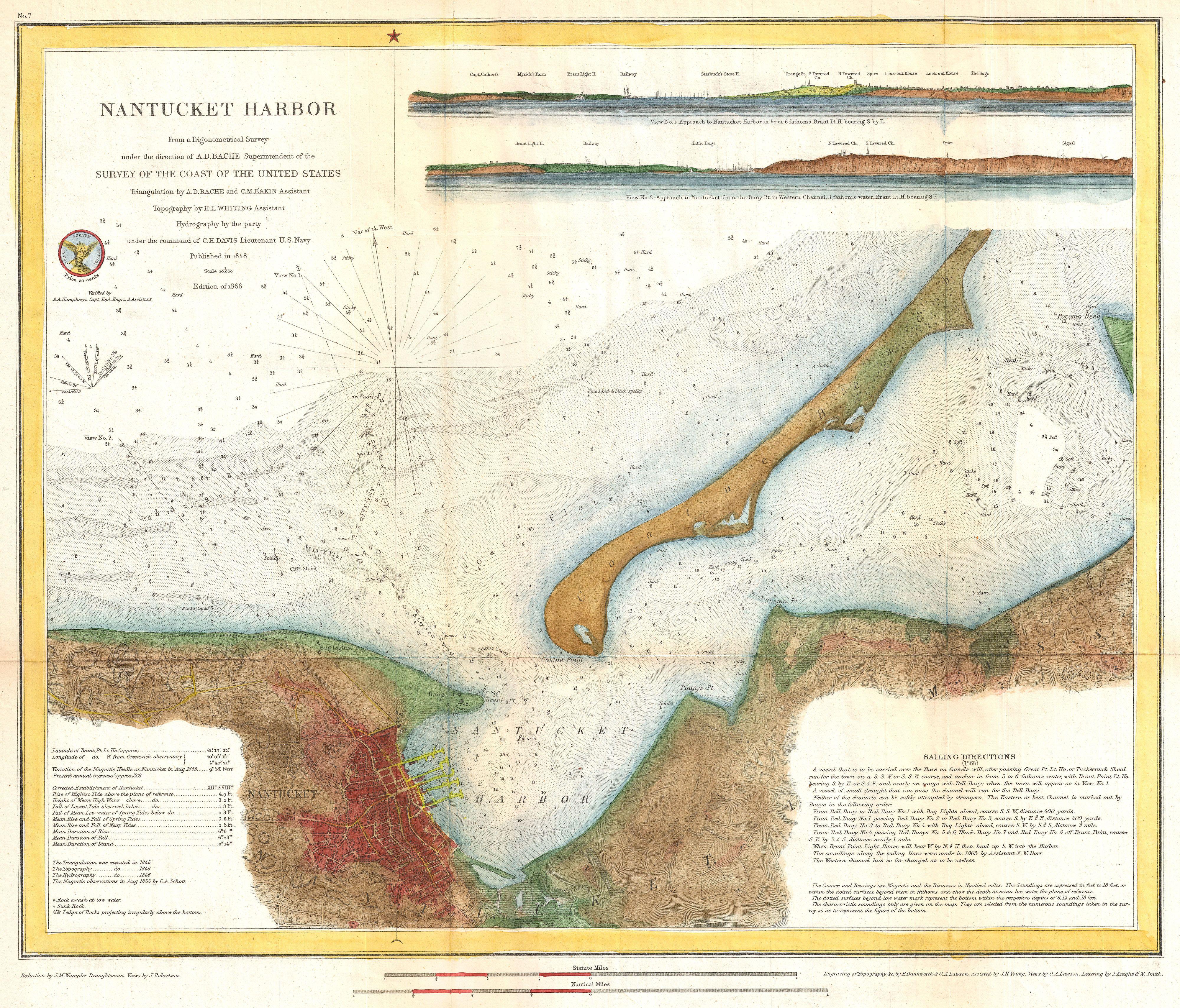
English: An extraordinary 1866 U.S. Coast Survey nautical chart or map of Nantucket Harbor, Massachusetts. Covers Nantucket Harbor on the northern part of Nantucket roughly from Whale's Rock to Pocomo Head. Includes the town of Nantucket as well as Coatue Beach. This is one of the rarest and most desirable charts issued by the U.S. Coast Survey. Offers superb nautical and inland detail. Includes countless depth soundings and inland detail to the level of individual streets, wharves and buildings. Identifies the Bug Lights, Range Light, Coatne Point, Brant Pint, Pumny's Point and Shemo Point, among others. Also identifies various undersea dangers such as flats, shoals, and rocks. There are two profile views in the upper right quadrant. Both views detail Nantucket Harbor from various directions and distances. Notes on the construction of this chart appear in the lower left hand quadrant. Sailing directions can be found in the lower right quadrant. The topography was executed H. L. Whiting. The Triangulation was accomplished by A. D. Bache and C. M Eakin. The Hydrography was completed by a party under the command of C. H. Davis. This chart was prepared under the supervision of A. D. Bache, one of the most influential Superintendents in the history of the Coast Survey. Issued in the 1867 supplement to the 1865 Superintendent's Report . |
|||||
| Date | 1866 (dated) | |||||
| Dimensions | height: 15 in (38.1 cm); width: 15 in (38.1 cm) | |||||
| Accession number |
Geographicus link: NantucketHarbor-uscs-1866 |
|||||
| Source/Photographer |
Report of the Superintendant of the United States Coast Survey, Washington, (1867 Supplement to the 1865 edition).
|
|||||
| Permission (Reusing this file) |
|
|||||
File history
Click on a date/time to view the file as it appeared at that time.
| Date/Time | Thumbnail | Dimensions | User | Comment | |
|---|---|---|---|---|---|
| current | 13:53, 23 March 2011 | | 4,000 × 3,418 (3.57 MB) | BotMultichillT (talk | contribs) | {{subst:User:Multichill/Geographicus |link=http://www.geographicus.com/P/AntiqueMap/NantucketHarbor-uscs-1866 |product_name=1866 U.S. Coast Survey Map of Nantucket Harbor, Nantucket |map_title=Nantucket Harbor. |description=An extraordinary 1866 U.S. Coas |
You cannot overwrite this file.
File usage on Commons
The following page uses this file: