File:1868 Lubowicze Zarudje map.PNG
Original file (1,865 × 850 pixels, file size: 2.99 MB, MIME type: image/png)
Captions
Captions
Summary edit
| Description |
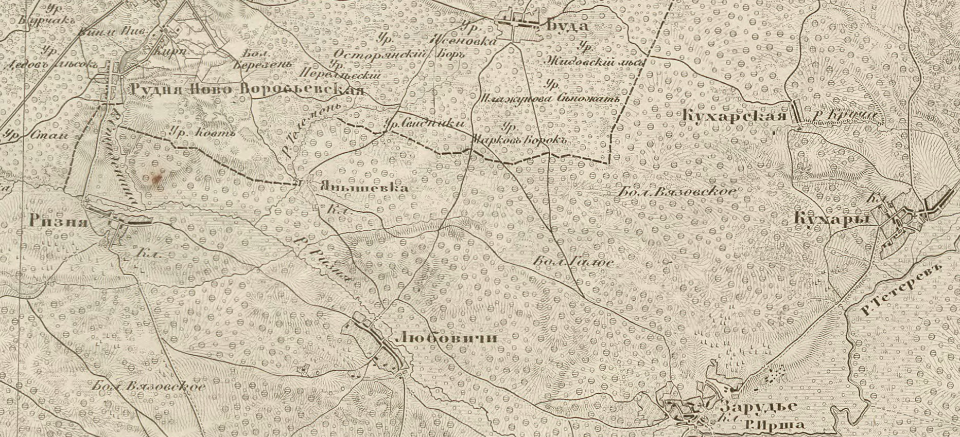
Українська: Села Заруддя, Кухарі, Любовичі, Різня, Янишівка (сучасна назва: Привітне) Малинської волості Радомисльського повіту на російській військово-топографічній мапі Київської губернії, 1868 рік
Русский: Карта 1868 года с изображением сел Любовичи и Зарудье Малинской волости Радомысльского уезда
English: Map of 1868 with the image of villages Lyubovychi and Zarud'ye (volost of Malyn, district of Radomysl) |
| Date | |
| Source | Військово-топографічна мапа Київської губернії |
| Author | Генріх Борнміллер |
Licensing edit
|
This work is in the public domain in its country of origin and other countries and areas where the copyright term is the author's life plus 70 years or fewer.
| |
| This file has been identified as being free of known restrictions under copyright law, including all related and neighboring rights. | |
File history
Click on a date/time to view the file as it appeared at that time.
| Date/Time | Thumbnail | Dimensions | User | Comment | |
|---|---|---|---|---|---|
| current | 15:10, 2 March 2016 | | 1,865 × 850 (2.99 MB) | Pvladko (talk | contribs) | якість |
| 12:15, 18 July 2013 | 1,582 × 491 (515 KB) | Pvladko (talk | contribs) | + Brightness and contrast | ||
| 11:19, 14 July 2013 | 1,582 × 491 (516 KB) | Pvladko (talk | contribs) | + | ||
| 11:06, 14 July 2013 | 1,262 × 392 (803 KB) | Pvladko (talk | contribs) | without watermarks | ||
| 14:58, 1 June 2011 | 1,278 × 396 (552 KB) | Pvladko (talk | contribs) | {{Information |Description ={{uk|1=Мапа 1868 року з зображенням сіл Любовичі та Заруддя Малинської волості Радомисльського повіту}} {{ru|1=Карта 1868 года с изо� |
You cannot overwrite this file.
File usage on Commons
There are no pages that use this file.
File usage on other wikis
The following other wikis use this file:
- Usage on ru.wikipedia.org
- Usage on uk.wikipedia.org
- Любовичі (Коростенський район)
- Привітне (Коростенський район)
- Різня (село)
- Рудня-Вороб'ївська
- Заруддя (Вишгородський район)
- Кухарі (Вишгородський район)
- Слобода-Кухарська
- Любовицьке лісництво
- Користувач:Alex Blokha/Дні згадані в Вікіпедії/Україна/3 грудня
- Галове (заказник)
- Телемень (притока Різні)
- Студень (річка)
- Usage on zh.wikipedia.org