File:1870 Johnson Map of Australia, the East Indies, and Southeast Asia - Geographicus - Australia-johnson-1870.jpg
Size of this preview: 438 × 599 pixels. Other resolutions: 175 × 240 pixels | 351 × 480 pixels | 562 × 768 pixels | 749 × 1,024 pixels | 1,498 × 2,048 pixels | 3,657 × 5,000 pixels.
Original file (3,657 × 5,000 pixels, file size: 6.54 MB, MIME type: image/jpeg)
Captions
Captions
Add a one-line explanation of what this file represents
| Alvin Jewett Johnson: Johnson's Australia and East Indies.
( |
|||||||||||||||||||||||
|---|---|---|---|---|---|---|---|---|---|---|---|---|---|---|---|---|---|---|---|---|---|---|---|
| Artist |
|
||||||||||||||||||||||
| Title |
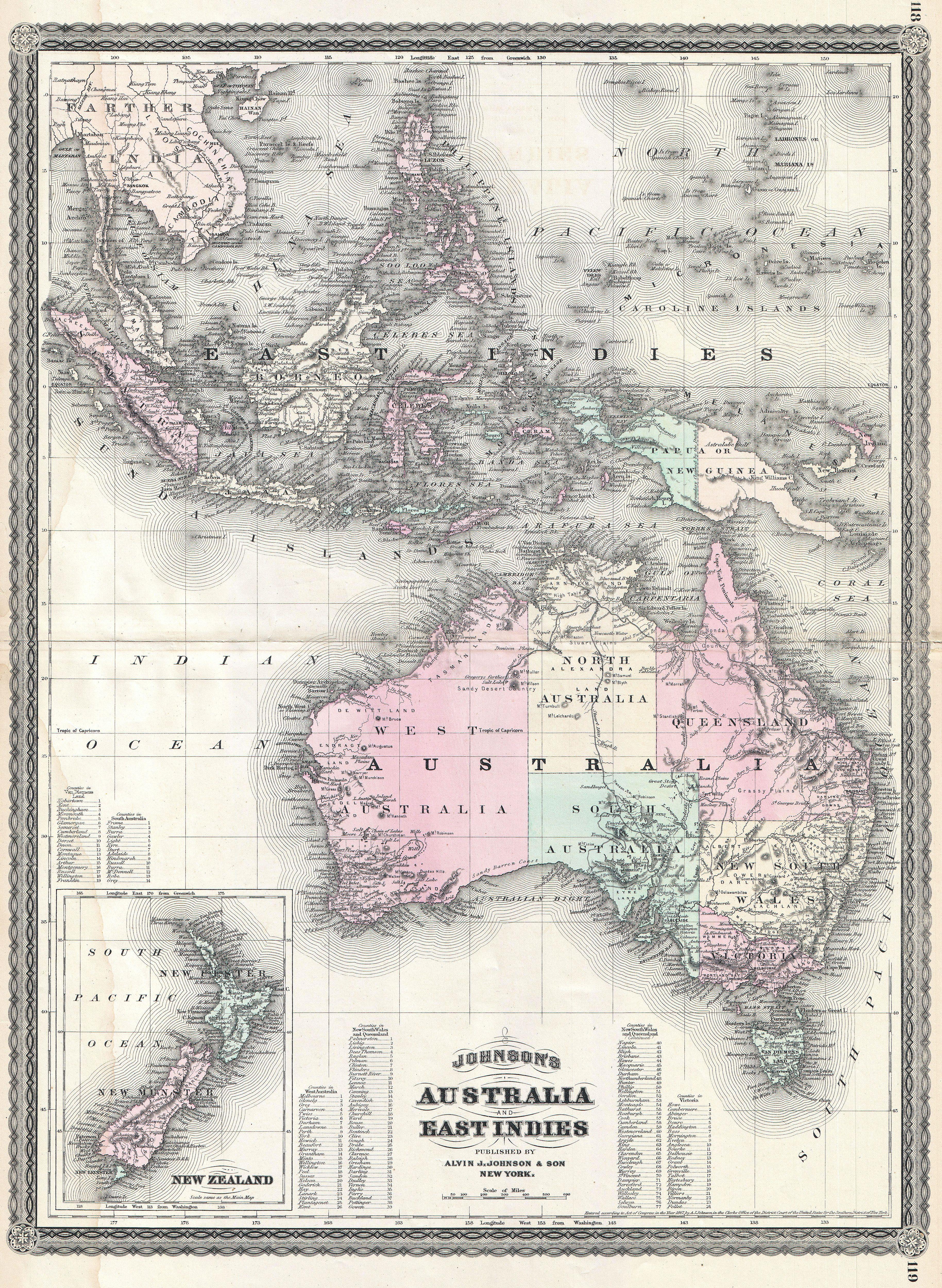
Johnson's Australia and East Indies. |
||||||||||||||||||||||
| Description |
English: This is A. J. Johnson’s 1870 map of Australia, the East Indies and Southeast Asia. Covers from Modern day Thailand and Vietnam south to include all of the East Indies, the Philippines, New Guinea and the continent of Australia. Offers superb detail with numerous islands, states, cities and geographical areas labeled and color coded. Shows an advanced state of Australian exploration noting the explorations of Burke, Wills, Stuart and Gregory. An inset in the lower left quadrant details New Zealand. Text in the lower quadrants notes counties in each province of Australia. Features the spirograph border common to Johnson’s atlas work in 1870. This map appeared only in the 1867 – 1870 run of Johnson’s atlases and is consequently among Johnson’s more uncommon maps. Prepared by A. J. Johnson for publication as page nos. 118 -119 in the rare 1870 edition of his New Illustrated Atlas… Dated and copyrighted, “Entered according to Act of Congress in the Year of 1867, by A. J. Johnson in the Clerks Office of the District Court of the United States for the Southern District of New York. |
||||||||||||||||||||||
| Date | 1867 (dated) | ||||||||||||||||||||||
| Dimensions | height: 23.5 in (59.6 cm); width: 17.5 in (44.4 cm) | ||||||||||||||||||||||
| Accession number |
Geographicus link: Australia-johnson-1870 |
||||||||||||||||||||||
| Source/Photographer |
Johnson's New Illustrated Family Atlas, (1867 edition).
|
||||||||||||||||||||||
| Permission (Reusing this file) |
|
||||||||||||||||||||||
File history
Click on a date/time to view the file as it appeared at that time.
| Date/Time | Thumbnail | Dimensions | User | Comment | |
|---|---|---|---|---|---|
| current | 18:37, 22 March 2011 | | 3,657 × 5,000 (6.54 MB) | BotMultichillT (talk | contribs) | {{subst:User:Multichill/Geographicus |link=http://www.geographicus.com/P/AntiqueMap/Australia-johnson-1870 |product_name=1870 Johnson Map of Australia, the East Indies, and Southeast Asia |map_title=Johnson's Australia and East Indies. |description=This i |
You cannot overwrite this file.
File usage on Commons
The following page uses this file:
File usage on other wikis
The following other wikis use this file:
- Usage on en.wikipedia.org
- Usage on he.wikipedia.org