File:1873 Beers Map of Brookhaven and Fire Island, Long Island, NY - Geographicus - BrookhavenS-beers-1873.jpg

Original file (4,000 × 2,567 pixels, file size: 1.69 MB, MIME type: image/jpeg)
Captions
Captions
| Part of Brookhaven, Sufffolk Co. L.I. | ||||||
|---|---|---|---|---|---|---|
| Artist | ||||||
| Title |
Part of Brookhaven, Sufffolk Co. L.I. |
|||||
| Description |
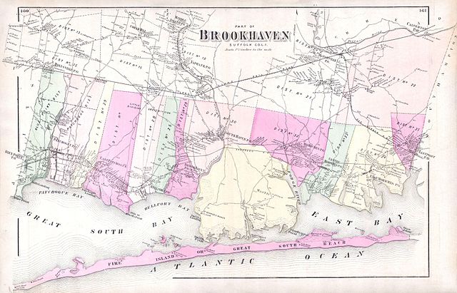
English: A scarce example of Fredrick W. Beers’ map of the southern part of Brookhaven, Long Island, New York. Published in 1873, this magnificent map covers Great South Bay and East Bay and along the coast from Blue Point and Patchogue Bay eastward past Bellport, Smith Point, Moriches to Eastport. Covers Fire Island from Watch Hill to Swan Island, detailing the homes of John Smith, H. F. Osborne Gunning, G. Terry and S. Havens. Extends inland as far north as Middle Island, Coram Hill, Manorville and Calverton. Notes the proposed route of the South Side Long Island Railroad. This is probably the finest atlas map of Brookhaven to appear in the 19th century. Prepared by Beers, Comstock & Cline out of their office at 36 Vesey Street, New York City, for inclusion in the first published atlas of Long Island, the 1873 issue of Atlas of Long Island, New York. |
|||||
| Date | 1873 (undated) | |||||
| Dimensions | height: 15 in (38.1 cm); width: 23 in (58.4 cm) | |||||
| Accession number |
Geographicus link: BrookhavenS-beers-1873 |
|||||
| Source/Photographer |
Atlas of Long Island, New York. From Recent Actual Surveys and Records Under the Superintendence of F. W. Beers. (1873 First Edition)
|
|||||
| Permission (Reusing this file) |
|
|||||
File history
Click on a date/time to view the file as it appeared at that time.
| Date/Time | Thumbnail | Dimensions | User | Comment | |
|---|---|---|---|---|---|
| current | 14:06, 16 March 2011 | | 4,000 × 2,567 (1.69 MB) | BotMultichill (talk | contribs) | {{subst:User:Multichill/Geographicus |link=http://www.geographicus.com/P/AntiqueMap/BrookhavenS-beers-1873 |product_name=1873 Beers Map of Brookhaven and Fire Island, Long Island, NY |map_title=Part of Brookhaven, Sufffolk Co. L.I. |description=A scarce e |
You cannot overwrite this file.
File usage on Commons
The following page uses this file: