File:1873 Beers Map of Jamaica Village, Queens, New York City - Geographicus - JamaicaVillage-beers-1873.jpg

Size of this preview: 795 × 600 pixels. Other resolutions: 318 × 240 pixels | 637 × 480 pixels | 1,018 × 768 pixels | 1,280 × 965 pixels | 2,560 × 1,931 pixels | 5,000 × 3,771 pixels.
Original file (5,000 × 3,771 pixels, file size: 4.66 MB, MIME type: image/jpeg)
Captions
Captions
Add a one-line explanation of what this file represents
| Jamaica Village, Queens Co. L.I. | |||
|---|---|---|---|
| Artist | |||
| Title |
Jamaica Village, Queens Co. L.I. |
||
| Description |
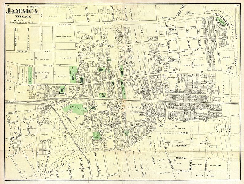
English: A scarce example of Frederick W. Beers’ map of the town of Jamaica Village, Queens, New York. Published in 1873. Covers roughly from modern day Highland Avenue to Atlantic Avenue, and from Myrtle Avenue to Franklin Avenue. Detailed to the level of individual buildings and properties with land owners noted. This is probably the finest atlas map of the town of Jamaica Queens, to appear in the 19th century. Prepared by Beers, Comstock & Cline out of their office at 36 Vesey Street, New York City, for inclusion in the first published atlas of Long Island, the 1873 issue of Atlas of Long Island, New York. |
||
| Date | 1873 (undated) | ||
| Dimensions | height: 17 in (43.1 cm); width: 22.5 in (57.1 cm) | ||
| Accession number |
Geographicus link: JamaicaVillage-beers-1873 |
||
| Source/Photographer |
Atlas of Long Island, New York. From Recent Actual Surveys and Records Under the Superintendence of F. W. Beers. (1873 First Edition).
|
||
| Permission (Reusing this file) |
|
||
| Other versions | File:Jamaica Village. Queens Co. L.I. (From Highland Avenue to Atlantic Avenue, and from Myrtle Avenue to Franklin Avenue.) NYPL1527299.tiff | ||
File history
Click on a date/time to view the file as it appeared at that time.
| Date/Time | Thumbnail | Dimensions | User | Comment | |
|---|---|---|---|---|---|
| current | 18:52, 16 March 2011 | | 5,000 × 3,771 (4.66 MB) | BotMultichill (talk | contribs) | {{subst:User:Multichill/Geographicus |link=http://www.geographicus.com/P/AntiqueMap/JamaicaVillage-beers-1873 |product_name=1873 Beers Map of Jamaica Village, Queens, New York City |map_title=Jamaica Village, Queens Co. L.I. |description=A scarce example |
You cannot overwrite this file.
File usage on Commons
The following page uses this file:
File usage on other wikis
The following other wikis use this file:
- Usage on en.wikipedia.org