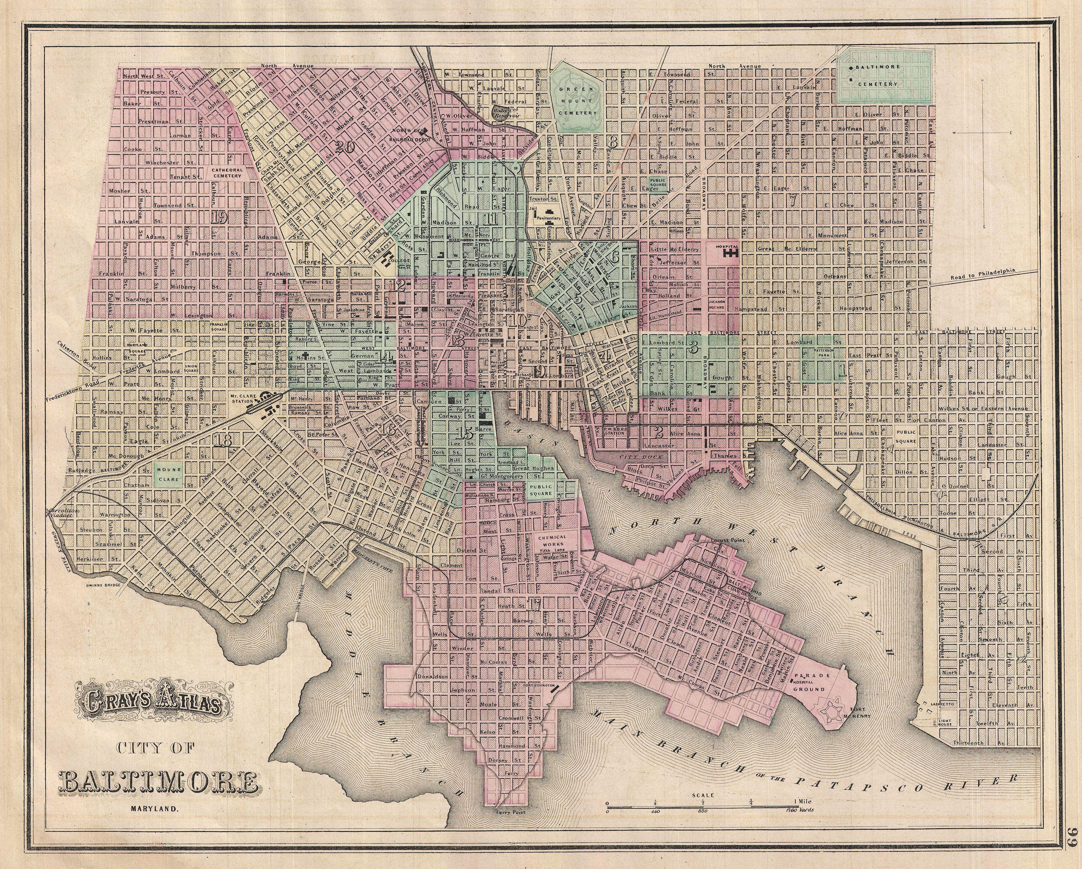
File:1874 Gray Map of Baltimore, Maryland - Geographicus - Baltimore-gray-1874.jpg
Original file (3,500 × 2,812 pixels, file size: 3.54 MB, MIME type: image/jpeg)
Captions
Captions
| Gray's Alas City of Baltimore Maryland. | ||||||
|---|---|---|---|---|---|---|
| Artist | ||||||
| Title |
Gray's Alas City of Baltimore Maryland. |
|||||
| Description |
English: A fine map of Baltimore from Gray’s 1874 Atlas of the United States. Covers the entire city from Gwinn’s Falls to Seventh Street and from Green Mountain Cemetery to the Patapsco River. Shows proposed landfills along the water’s edge. Important churches, transport hubs, and civic buildings are noted throughout. Hand colored in red, green, and yellow pastels according to city ward. Lower left features a decorative title in embellished text – uncommon for Gray who was a minimalist in this regard. |
|||||
| Date | 1874 (undated) | |||||
| Dimensions | height: 12 in (30.4 cm); width: 15.5 in (39.3 cm) | |||||
| Accession number |
Geographicus link: Baltimore-gray-1874 |
|||||
| Source/Photographer |
Gray, O., Gray's Atlas, 1874.
|
|||||
| Permission (Reusing this file) |
|
|||||
File history
Click on a date/time to view the file as it appeared at that time.
| Date/Time | Thumbnail | Dimensions | User | Comment | |
|---|---|---|---|---|---|
| current | 06:31, 25 March 2011 | | 3,500 × 2,812 (3.54 MB) | BotMultichillT (talk | contribs) | {{subst:User:Multichill/Geographicus |link=http://www.geographicus.com/P/AntiqueMap/Baltimore-gray-1874 |product_name=1874 Gray Map of Baltimore, Maryland |map_title=Gray's Alas City of Baltimore Maryland. |description=A fine map of Baltimore from Gray’ |
You cannot overwrite this file.
File usage on Commons
The following page uses this file: