File:1878 Bien and Johnson Map of New York City (Manhattan Island) During the Revolutionary War - Geographicus - NewYorkCity-johnsonbien-1878.jpg

Size of this preview: 799 × 327 pixels. Other resolutions: 320 × 131 pixels | 640 × 262 pixels | 1,024 × 419 pixels | 1,280 × 524 pixels | 2,560 × 1,048 pixels | 6,000 × 2,456 pixels.
Original file (6,000 × 2,456 pixels, file size: 3.96 MB, MIME type: image/jpeg)
Captions
Captions
Add a one-line explanation of what this file represents
Summary edit
_During_the_Revolutionary_War_-_Geographicus_-_NewYorkCity-johnsonbien-1878.jpg&action=edit§ion=1)
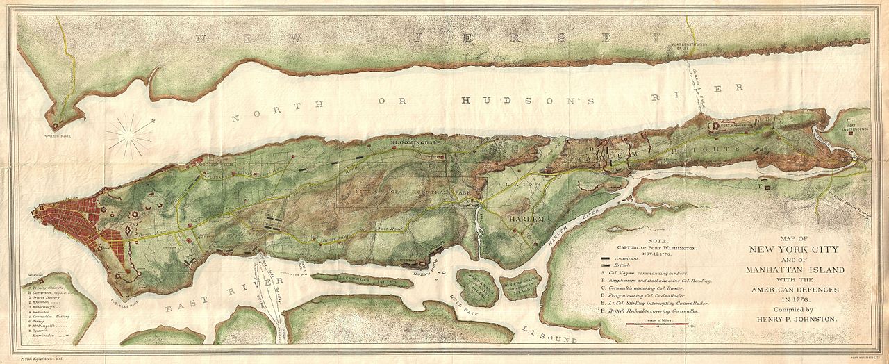
| English: Map of New York City and of Manhattan Island with the American Defences in 1776. | |||
|---|---|---|---|
| Artist | |||
| Title |
English: Map of New York City and of Manhattan Island with the American Defences in 1776. |
||
| Description |
English: An unusual map of Manhattan Island will adjacent parts of Long Island and New Jersey drawn in 1878 for issue in Henry P. Johnston's history of the Battle of Long Island and the loss of New York. In compiling his history Johnston was frustrated by the lack of a Revolutionary War period map detailing the entire Island of Manhattan. He thus compiled this map which he published with Julius Bien and incorporated into his book. Though quite late compared to colonial period information it presents, this map is significant in that it is possibly the first map to show the whole of Manhattan Island during the Revolutionary War. Cartographically it is based upon the work of Ratzer and Montresor with regard to the southern part of the Island as far north as 50th street. North of 50th street it incorporates data from the Commissioners' Plan of 1811 and from Sauthier's map of New York. Beyond the developed southern portions of the city that extend north only as far as modern day Canal Street the city is laid out topographically, with hills, river courses, and plains apparent. Bloomingdale Road (modern day Broadway) is identified as is the Kings Bridge or Post Road. Shows various fortifications throughout as well as military notations regarding the placement of British and American troops. Though fiercely fought the British ultimately won the Battle of Long Island and the Battle of Fort Washington, thus seizing control of New York City, which they maintained until the end of the Revolutionary War. |
||
| Date | 1878 (undated) | ||
| Dimensions | height: 14.5 in (36.8 cm); width: 35 in (88.9 cm) | ||
| Accession number |
Geographicus link: NewYorkCity-johnsonbien-1878 |
||
| Source/Photographer |
Johnston, Henry P., The Campaign of 1776 around New York and Brooklyn
|
||
Licensing edit
_During_the_Revolutionary_War_-_Geographicus_-_NewYorkCity-johnsonbien-1878.jpg&action=edit§ion=2)
|
This is a faithful photographic reproduction of a two-dimensional, public domain work of art. The work of art itself is in the public domain for the following reason:
The official position taken by the Wikimedia Foundation is that "faithful reproductions of two-dimensional public domain works of art are public domain".
This photographic reproduction is therefore also considered to be in the public domain in the United States. In other jurisdictions, re-use of this content may be restricted; see Reuse of PD-Art photographs for details. | ||||
File history
Click on a date/time to view the file as it appeared at that time.
| Date/Time | Thumbnail | Dimensions | User | Comment | |
|---|---|---|---|---|---|
| current | 09:34, 24 March 2011 | 6,000 × 2,456 (3.96 MB) | BotMultichillT (talk | contribs) | {{subst:User:Multichill/Geographicus |link=http://www.geographicus.com/P/AntiqueMap/NewYorkCity-johnsonbien-1878 |product_name=1878 Bien and Johnson Map of New York City (Manhattan Island) During the Revolutionary War |map_title=Map of New York City and o |
You cannot overwrite this file.
File usage on Commons
The following page uses this file:
_During_the_Revolutionary_War_-_Geographicus_-_NewYorkCity-johnsonbien-1878.jpg)
_During_the_Revolutionary_War_-_Geographicus_-_NewYorkCity-johnsonbien-1878.jpg&oldid=745919673)