File:1890 Stratenplan Middelland Rotterdam rondom de Nieuwe Binnenweg.jpg

Size of this preview: 495 × 599 pixels. Other resolutions: 198 × 240 pixels | 396 × 480 pixels | 634 × 768 pixels | 846 × 1,024 pixels | 1,692 × 2,048 pixels | 6,702 × 8,112 pixels.
Original file (6,702 × 8,112 pixels, file size: 4.96 MB, MIME type: image/jpeg)
Captions
Captions
Add a one-line explanation of what this file represents
Summary edit
| Description |
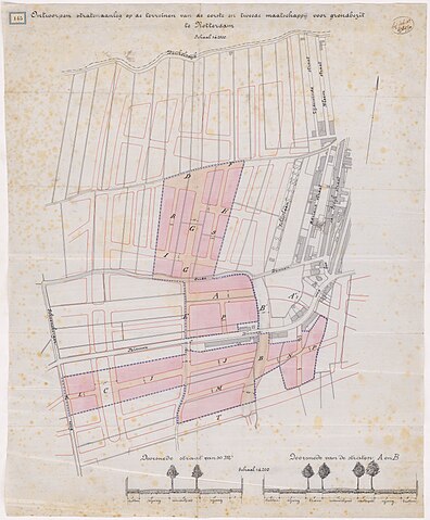
Nederlands: Stratenplan voor de nieuwe wijk Middelland in Rotterdam-West rondom de nieuw aangelegde Nieuwe Binnenweg. Van ouds liep hier doorgaande weg de Oude Binnenweg, ooit gewoon de Binnenweg, en de Schonebergerweg van Rotterdam naar Schonderloo, een gehucht naast Delfshaven. Rond 1890 was de Nieuwe Binnenweg reeds aangelegd en ook de 's-Gravendijkwal, die toen nog de Schietbaanlaan genoemd werd. Met de uiteindelijke inrichting is het deel van de Oude Binnenweg opgelost en kwam daar de "nieuwe" huidige Schietbaanlaan. |
| Date | |
| Source | 1890-145 Calque op linnen van de ontworpen stratenaanleg op de terreinen van de eerste en tweede maatschappij voor grondbezit. Collectie: Rotondetekeningen ; Gemeente Rotterdam (Stadsarchief) |
| Author | Anoniem ; Auteursrechthouder: Gemeente Rotterdam (Stadsarchief) |
Licensing edit
|
This work is in the public domain in its country of origin and other countries and areas where the copyright term is the author's life plus 100 years or fewer. | |
| This file has been identified as being free of known restrictions under copyright law, including all related and neighboring rights. | |
File history
Click on a date/time to view the file as it appeared at that time.
| Date/Time | Thumbnail | Dimensions | User | Comment | |
|---|---|---|---|---|---|
| current | 00:49, 17 January 2024 | | 6,702 × 8,112 (4.96 MB) | Mdd (talk | contribs) | Uploaded a work by Anoniem ; Auteursrechthouder: Gemeente Rotterdam (Stadsarchief) from [https://hdl.handle.net/21.12133/C41F6A1C5D1B4998BFCC9B3B25F9C083 1890-145 Calque op linnen van de ontworpen stratenaanleg op de terreinen van de eerste en tweede maatschappij voor grondbezit.] Collectie: Rotondetekeningen ; Gemeente Rotterdam (Stadsarchief) with UploadWizard |
You cannot overwrite this file.
File usage on Commons
There are no pages that use this file.