File:1896 map of Syrian Kurdistan.jpg

Size of this preview: 800 × 386 pixels. Other resolutions: 320 × 154 pixels | 640 × 309 pixels | 1,024 × 494 pixels | 1,280 × 617 pixels | 2,560 × 1,234 pixels | 4,964 × 2,393 pixels.
Original file (4,964 × 2,393 pixels, file size: 1.28 MB, MIME type: image/jpeg)
Captions
Captions
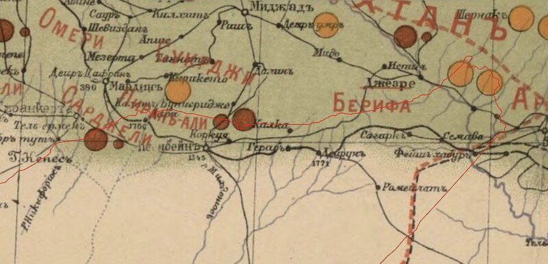
Russian map dated 1896 showing the distribution of Kurds in Syrian Kurdistan
Summary edit
| Description |
English: A Russian map of the distribution of Kurds in the Ottoman, Persian & Russian Empires at the end of the 19th century, authored by General Staff Colonel Vladimir Kartsov.
Notes: - The red line was added to a modified version of the map to show the regions of Syrian Kurdistan - Sunni Kurds are represented in green, Armenians in dark brown, Nestorians and Chaldeans in orange - The names of the Kurdish tribes are written in red |
| Date | |
| Source | 2 |
| Author | General Staff Colonel Vladimir Kartsov, Own work |
Licensing edit
|
This work is in the public domain in its country of origin and other countries and areas where the copyright term is the author's life plus 70 years or fewer. This work is in the public domain in the United States because it was published (or registered with the U.S. Copyright Office) before January 1, 1929. | |
| This file has been identified as being free of known restrictions under copyright law, including all related and neighboring rights. | |
File history
Click on a date/time to view the file as it appeared at that time.
| Date/Time | Thumbnail | Dimensions | User | Comment | |
|---|---|---|---|---|---|
| current | 20:42, 16 October 2023 | | 4,964 × 2,393 (1.28 MB) | Sulaimanl (talk | contribs) | Uploaded a work by General Staff Colonel Vladimir Kartsov, {{own}} from [https://www.oldmapsonline.org/maps/dd9289f2-baab-4347-950c-375aecebd014/ 1] [http://saradistribution.com/kurdishmaps.htm 2] with UploadWizard |
You cannot overwrite this file.
File usage on Commons
There are no pages that use this file.