File:1902 Andes Boundary Case de.svg

Size of this PNG preview of this SVG file: 499 × 599 pixels. Other resolutions: 200 × 240 pixels | 400 × 480 pixels | 639 × 768 pixels | 852 × 1,024 pixels | 1,705 × 2,048 pixels | 537 × 645 pixels.
Original file (SVG file, nominally 537 × 645 pixels, file size: 1.02 MB)
File information
Structured data
Captions
Captions
Add a one-line explanation of what this file represents
Summary
edit| Description1902 Andes Boundary Case de.svg |
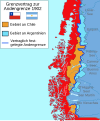
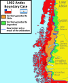
Deutsch: Übersichtskarte zum Anden-Grenzvertrag zwischen Chile und Argentinien 1902.
English: This map shows the disputed territories between Chile and Argentina between 1881 and 1902 and its resolution with the arbitration of King Edward VII.
Español: Este mapa muestra los territorios en disputa entre Chile y Argentina entre los años 1881 y 1902 y su resolución con el Laudo arbitral del rey Eduardo VII del Reino Unido. |
| Date | |
| Source |
Own work Based on: [1] [2][3][4] |
| Author | Janitoalevic, German translation, color adaptions, SVG optimization, etc. by Furfur |
| Other versions |
|
Licensing
editI, the copyright holder of this work, hereby publish it under the following license:
This file is licensed under the Creative Commons Attribution-Share Alike 4.0 International license.
- You are free:
- to share – to copy, distribute and transmit the work
- to remix – to adapt the work
- Under the following conditions:
- attribution – You must give appropriate credit, provide a link to the license, and indicate if changes were made. You may do so in any reasonable manner, but not in any way that suggests the licensor endorses you or your use.
- share alike – If you remix, transform, or build upon the material, you must distribute your contributions under the same or compatible license as the original.
File history
Click on a date/time to view the file as it appeared at that time.
| Date/Time | Thumbnail | Dimensions | User | Comment | |
|---|---|---|---|---|---|
| current | 17:21, 23 October 2023 |  | 537 × 645 (1.02 MB) | Janitoalevic (talk | contribs) | Borders |
| 00:33, 29 December 2022 |  | 537 × 645 (1.01 MB) | Janitoalevic (talk | contribs) | Southern Patagonian Ice Field presition | |
| 17:09, 31 December 2018 |  | 537 × 645 (856 KB) | Furfur (talk | contribs) | =={{int:filedesc}}== {{Information |description={{de|1=Übersichtskarte zum Anden-Grenzvertrag zwischen Chile und Argentinien 1902.}} {{en|1=This map shows the disputed territories between Chile and Argentina between 1881 and 1902 and its resolution with the arbitration of King Edward VII.}} {{es|1=Este mapa muestra los territorios en disputa entre Chile y Argentina entre los años 1881 y 1902 y su resolución con el Laudo arbitral del rey Eduardo VII del Reino Unido.}} |date=2018-12-31 |source=... |
You cannot overwrite this file.
File usage on Commons
The following 3 pages use this file:
File usage on other wikis
The following other wikis use this file:
- Usage on de.wikipedia.org
Metadata
This file contains additional information such as Exif metadata which may have been added by the digital camera, scanner, or software program used to create or digitize it. If the file has been modified from its original state, some details such as the timestamp may not fully reflect those of the original file. The timestamp is only as accurate as the clock in the camera, and it may be completely wrong.
| Width | 536.5px |
|---|---|
| Height | 645px |

