File:1912 Northeast and Southwest Elevations, Sections - St. Stephen's Episcopal Church, 3439 Main Highway, Coconut Grove, Miami-Dade County, FL HABS FL-567 (sheet 3 of 12).png

Size of this preview: 463 × 599 pixels. Other resolutions: 185 × 240 pixels | 371 × 480 pixels | 593 × 768 pixels | 791 × 1,024 pixels | 1,582 × 2,048 pixels | 13,590 × 17,588 pixels.
Original file (13,590 × 17,588 pixels, file size: 3.8 MB, MIME type: image/png)
Captions
Captions
Add a one-line explanation of what this file represents
| This image is a JPEG version of the original TIF image at File: 1912 Northeast and Southwest Elevations, Sections - St. Stephen's Episcopal Church, 3439 Main Highway, Coconut Grove, Miami-Dade County, FL HABS FL-567 (sheet 3 of 12).tif.
However, any edits to the image should be based on the original TIF version in order to prevent generation loss, and both versions should be updated. Do not make edits based on this version. |
Summary edit
| Warning | The original file is very high-resolution. It might not load properly or could cause your browser to freeze when opened at full size. |
|---|
| 1912 Northeast and Southwest Elevations, Sections - St. Stephen's Episcopal Church, 3439 Main Highway, Coconut Grove, Miami-Dade County, FL | ||||
|---|---|---|---|---|
| Photographer |
Related names:
|
|||
| Title |
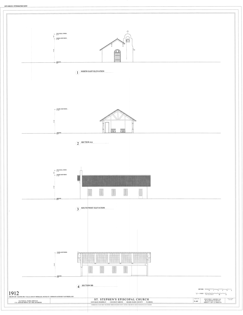
1912 Northeast and Southwest Elevations, Sections - St. Stephen's Episcopal Church, 3439 Main Highway, Coconut Grove, Miami-Dade County, FL |
|||
| Depicted place | Florida; Miami-Dade County; Coconut Grove | |||
| Date | Documentation compiled after 1933 | |||
| Current location |
Library of Congress Prints and Photographs Division Washington, D.C. 20540 USA http://hdl.loc.gov/loc.pnp/pp.print |
|||
| Accession number |
HABS FL-567 (sheet 3 of 12) |
|||
| Credit line |
|
|||
| Notes |
|
|||
| Source | https://www.loc.gov/pictures/item/fl0712.sheet.00003a | |||
| Permission (Reusing this file) |
|
|||
| Other versions |
.png) .png) .png) .png) .png) .png) .png) .png) .png) .png) .png) |
|||

.png&action=edit§ion=1)
| Object location | | View this and other nearby images on: OpenStreetMap |
|---|
.png¶ms=025.712220_N_-080.257220_E_globe:Earth_class:object_type:object__&language=en)
File history
Click on a date/time to view the file as it appeared at that time.
| Date/Time | Thumbnail | Dimensions | User | Comment | |
|---|---|---|---|---|---|
| current | 12:48, 18 July 2014 | | 13,590 × 17,588 (3.8 MB) | Fæ (talk | contribs) | {{Compressed version|file=File:1912_Northeast_and_Southwest_Elevations,_Sections_-_St._Stephen's_Episcopal_Church,_3439_Main_Highway,_Coconut_Grove,_Miami-Dade_County,_FL_HABS_FL-567_(sheet_3_of_12).tif|thumb=nothumb}} =={{int:filedesc}}== {{Photograp... |
You cannot overwrite this file.
File usage on Commons
The following 24 pages use this file:
- File:1912 Floor Plan and Roof Plan - St. Stephen's Episcopal Church, 3439 Main Highway, Coconut Grove, Miami-Dade County, FL HABS FL-567 (sheet 2 of 12).png
- File:1912 Floor Plan and Roof Plan - St. Stephen's Episcopal Church, 3439 Main Highway, Coconut Grove, Miami-Dade County, FL HABS FL-567 (sheet 2 of 12).tif
- File:1912 Northeast and Southwest Elevations, Sections - St. Stephen's Episcopal Church, 3439 Main Highway, Coconut Grove, Miami-Dade County, FL HABS FL-567 (sheet 3 of 12).png
- File:1912 Northeast and Southwest Elevations, Sections - St. Stephen's Episcopal Church, 3439 Main Highway, Coconut Grove, Miami-Dade County, FL HABS FL-567 (sheet 3 of 12).tif
- File:1949 Floor Plan - St. Stephen's Episcopal Church, 3439 Main Highway, Coconut Grove, Miami-Dade County, FL HABS FL-567 (sheet 4 of 12).png
- File:1949 Floor Plan - St. Stephen's Episcopal Church, 3439 Main Highway, Coconut Grove, Miami-Dade County, FL HABS FL-567 (sheet 4 of 12).tif
- File:1949 Northwest, Northeast, and Southwest Elevations, Section - St. Stephen's Episcopal Church, 3439 Main Highway, Coconut Grove, Miami-Dade County, FL HABS FL-567 (sheet 6 of 12).png
- File:1949 Northwest, Northeast, and Southwest Elevations, Section - St. Stephen's Episcopal Church, 3439 Main Highway, Coconut Grove, Miami-Dade County, FL HABS FL-567 (sheet 6 of 12).tif
- File:1949 Roof Plan - St. Stephen's Episcopal Church, 3439 Main Highway, Coconut Grove, Miami-Dade County, FL HABS FL-567 (sheet 5 of 12).png
- File:1949 Roof Plan - St. Stephen's Episcopal Church, 3439 Main Highway, Coconut Grove, Miami-Dade County, FL HABS FL-567 (sheet 5 of 12).tif
- File:1949 Southeast Elevation, Section - St. Stephen's Episcopal Church, 3439 Main Highway, Coconut Grove, Miami-Dade County, FL HABS FL-567 (sheet 7 of 12).png
- File:1949 Southeast Elevation, Section - St. Stephen's Episcopal Church, 3439 Main Highway, Coconut Grove, Miami-Dade County, FL HABS FL-567 (sheet 7 of 12).tif
- File:2009 Floor Plan - St. Stephen's Episcopal Church, 3439 Main Highway, Coconut Grove, Miami-Dade County, FL HABS FL-567 (sheet 8 of 12).png
- File:2009 Floor Plan - St. Stephen's Episcopal Church, 3439 Main Highway, Coconut Grove, Miami-Dade County, FL HABS FL-567 (sheet 8 of 12).tif
- File:2009 Northeast Elevation and Sections - St. Stephen's Episcopal Church, 3439 Main Highway, Coconut Grove, Miami-Dade County, FL HABS FL-567 (sheet 11 of 12).png
- File:2009 Northeast Elevation and Sections - St. Stephen's Episcopal Church, 3439 Main Highway, Coconut Grove, Miami-Dade County, FL HABS FL-567 (sheet 11 of 12).tif
- File:2009 Northwest, Southwest and Southeast Elevations, Sections - St. Stephen's Episcopal Church, 3439 Main Highway, Coconut Grove, Miami-Dade County, FL HABS FL-567 (sheet 10 of 12).png
- File:2009 Northwest, Southwest and Southeast Elevations, Sections - St. Stephen's Episcopal Church, 3439 Main Highway, Coconut Grove, Miami-Dade County, FL HABS FL-567 (sheet 10 of 12).tif
- File:2009 Roof Plan - St. Stephen's Episcopal Church, 3439 Main Highway, Coconut Grove, Miami-Dade County, FL HABS FL-567 (sheet 9 of 12).png
- File:2009 Roof Plan - St. Stephen's Episcopal Church, 3439 Main Highway, Coconut Grove, Miami-Dade County, FL HABS FL-567 (sheet 9 of 12).tif
- File:Medallion, Rose Window, Plaque, and Key Plan - St. Stephen's Episcopal Church, 3439 Main Highway, Coconut Grove, Miami-Dade County, FL HABS FL-567 (sheet 12 of 12).png
- File:Medallion, Rose Window, Plaque, and Key Plan - St. Stephen's Episcopal Church, 3439 Main Highway, Coconut Grove, Miami-Dade County, FL HABS FL-567 (sheet 12 of 12).tif
- File:Site Plan - St. Stephen's Episcopal Church, 3439 Main Highway, Coconut Grove, Miami-Dade County, FL HABS FL-567 (sheet 1 of 12).png
- File:Site Plan - St. Stephen's Episcopal Church, 3439 Main Highway, Coconut Grove, Miami-Dade County, FL HABS FL-567 (sheet 1 of 12).tif
.png)
.png&oldid=746580160)