File:1914 map - Flemmings Karte für das türkische Interessen-Gebiet - die Türkei und die Grenzgebiete mit Rußland, Balkanstaaten, Großbritannien, Italien, Serbien.tif

Size of this JPG preview of this TIF file: 729 × 599 pixels. Other resolutions: 292 × 240 pixels | 584 × 480 pixels | 934 × 768 pixels | 1,246 × 1,024 pixels | 2,491 × 2,048 pixels | 10,149 × 8,343 pixels.
Original file (10,149 × 8,343 pixels, file size: 45.79 MB, MIME type: image/tiff)
Captions
Captions
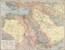
1914 map - Flemmings Karte für das türkische Interessen-Gebiet - die Türkei und die Grenzgebiete mit Rußland, Balkanstaaten, Großbritannien, Italien, Serbien
Summary edit
| Warning | The original file is very high-resolution. It might not load properly or could cause your browser to freeze when opened at full size. |
|---|
| Description |
English: 1914 map - Flemmings Karte für das türkische Interessen-Gebiet - die Türkei und die Grenzgebiete mit Rußland, Balkanstaaten, Großbritannien, Italien, Serbien |
| Date | |
| Source | http://resolver.staatsbibliothek-berlin.de/SBB0000E96800220000 |
| Author | Carl Flemming Verlag |
| Other versions |
Licensing edit
|
This work is in the public domain in its country of origin and other countries and areas where the copyright term is the author's life plus 70 years or fewer. This work is in the public domain in the United States because it was published (or registered with the U.S. Copyright Office) before January 1, 1929. | |
| This file has been identified as being free of known restrictions under copyright law, including all related and neighboring rights. | |
File history
Click on a date/time to view the file as it appeared at that time.
| Date/Time | Thumbnail | Dimensions | User | Comment | |
|---|---|---|---|---|---|
| current | 20:37, 7 October 2019 |  | 10,149 × 8,343 (45.79 MB) | Balkanique (talk | contribs) | User created page with UploadWizard |
You cannot overwrite this file.
File usage on Commons
The following 2 pages use this file: