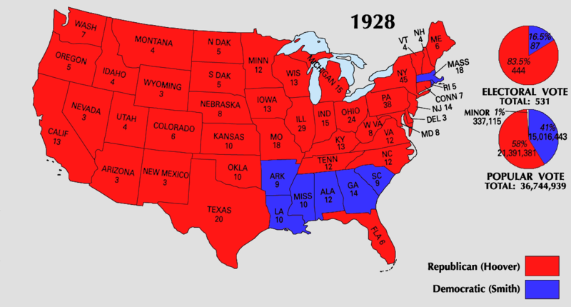
File:1928 Electoral Map.png

Size of this preview: 800 × 430 pixels. Other resolutions: 320 × 172 pixels | 640 × 344 pixels | 1,182 × 635 pixels.
Original file (1,182 × 635 pixels, file size: 169 KB, MIME type: image/png)
Captions
Captions
Add a one-line explanation of what this file represents
| U.S. presidential election maps from the National Atlas of the United States |
| See also: SVG maps |
| 1789 · 1792 · 1796 · 1800 · 1804 · 1808 · 1812 · 1816 · 1820 · 1824 · 1828 · 1832 · 1836 · 1840 · 1844 · 1848 · 1852 · 1856 · 1860 · 1864 · 1868 · 1872 · 1876 · 1880 · 1884 · 1888 · 1892 · 1896 · 1900 · 1904 · 1908 · 1912 · 1916 · 1920 · 1924 · 1928 · 1932 · 1936 · 1940 · 1944 · 1948 · 1952 · 1956 · 1960 · 1964 · 1968 · 1972 · 1976 · 1980 · 1984 · 1988 · 1992 · 1996 · 2000 · 2004 |
Summary edit
| Description | ||||
| Source | https://nationalmap.gov/small_scale/printable/elections.html | |||
| Author | United States Geological Survey | |||
| Other versions |
|


Licensing edit
This map was obtained from an edition of the National Atlas of the United States. Like almost all works of the U.S. federal government, works from the National Atlas are in the public domain in the United States.
Online access: NationalAtlas.gov | 1970 print edition: Library of Congress, Perry-Castañeda Library
|
File history
Click on a date/time to view the file as it appeared at that time.
| Date/Time | Thumbnail | Dimensions | User | Comment | |
|---|---|---|---|---|---|
| current | 22:21, 25 June 2008 | | 1,182 × 635 (169 KB) | Tallicfan20 (talk | contribs) | higher quality |
| 05:00, 25 May 2008 |  | 1,182 × 635 (138 KB) | Tallicfan20 (talk | contribs) | better coloring | |
| 04:53, 17 May 2008 |  | 1,182 × 635 (96 KB) | Tallicfan20 (talk | contribs) | {{PD-USGov-Atlas}} |
You cannot overwrite this file.
File usage on Commons
The following 2 pages use this file:
File usage on other wikis
The following other wikis use this file:
- Usage on en.wikipedia.org
- Usage on ko.wikipedia.org
- Usage on ru.wikipedia.org
- Usage on sv.wikipedia.org