File:1948 M.T.A. Boston map.jpg

Size of this preview: 360 × 600 pixels. Other resolutions: 144 × 240 pixels | 288 × 480 pixels | 461 × 768 pixels | 1,261 × 2,100 pixels.
Original file (1,261 × 2,100 pixels, file size: 765 KB, MIME type: image/jpeg)
Captions
Captions
Add a one-line explanation of what this file represents
| Description |
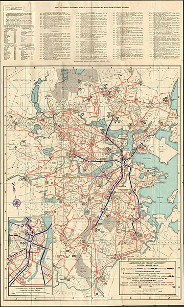
English: The first M.T.A. system map after its 1947 takeover from the Boston Elevated Railway, showing the heavy rail and streetcar network and proposed routes. The 1952 extension to Orient Heights is shown under construction, while a never-realized second tunnel between Park Street and Scollay Square (Government Center) and relocation of part of the Washington Street Elevated under Shawmut Avenue are shown as proposed. |
|||
| Date | ||||
| Source | Scanned map from collection of reddit user "holebutt" | |||
| Author | Richard F. Lufkin | |||
| Permission (Reusing this file) |
Not listed in Copyright Renewal Records so it has become public domain. |

File history
Click on a date/time to view the file as it appeared at that time.
| Date/Time | Thumbnail | Dimensions | User | Comment | |
|---|---|---|---|---|---|
| current | 00:43, 10 June 2013 | | 1,261 × 2,100 (765 KB) | Pi.1415926535 (talk | contribs) | {{Information |Description ={{en|1=The first M.T.A. system map after its 1947 takeover from the Boston Elevated Railway, showing the heavy rail and streetcar network and proposed routes. The 1952 extension to Orient Heights is shown under constructi... |
You cannot overwrite this file.
File usage on Commons
There are no pages that use this file.