File:1983 Valencia local election by neighborhood.svg

Size of this PNG preview of this SVG file: 216 × 461 pixels. Other resolutions: 112 × 240 pixels | 225 × 480 pixels | 360 × 768 pixels | 480 × 1,024 pixels | 959 × 2,048 pixels.
Original file (SVG file, nominally 216 × 461 pixels, file size: 210 KB)
Captions
Captions
Map of neighborhood results of the 1979 local election in Valencia
Summary edit
| Description |
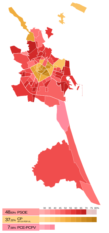
Español: Los barrios han sido coloreados según el porcentaje sobre el total de votos a candidaturas alcanzado por la formación que obtuvo más apoyos en dicha demarcación.
English: The different shades indicate the share of votes attained by the party which gathered the most votes in each neighborhood.
Català: Els barris han sigut colorats segons el percentatge alcançat per la llista electoral que va rebre més vots a cadascuna de les zones. |
| Date | |
| Source | Own work |
| Author | MP DDT |
Licensing edit
I, the copyright holder of this work, hereby publish it under the following license:
This file is licensed under the Creative Commons Attribution-Share Alike 4.0 International license.
- You are free:
- to share – to copy, distribute and transmit the work
- to remix – to adapt the work
- Under the following conditions:
- attribution – You must give appropriate credit, provide a link to the license, and indicate if changes were made. You may do so in any reasonable manner, but not in any way that suggests the licensor endorses you or your use.
- share alike – If you remix, transform, or build upon the material, you must distribute your contributions under the same or compatible license as the original.
File history
Click on a date/time to view the file as it appeared at that time.
| Date/Time | Thumbnail | Dimensions | User | Comment | |
|---|---|---|---|---|---|
| current | 15:50, 4 October 2023 | | 216 × 461 (210 KB) | MP DDT (talk | contribs) | Borders of Benimaclet-Saïdia-Rascanya |
| 13:33, 28 September 2023 |  | 216 × 461 (209 KB) | MP DDT (talk | contribs) | Color change | |
| 21:08, 21 August 2023 |  | 216 × 461 (209 KB) | MP DDT (talk | contribs) | PCPV box | |
| 20:50, 21 August 2023 |  | 216 × 446 (206 KB) | MP DDT (talk | contribs) | Uploaded own work with UploadWizard |
You cannot overwrite this file.
File usage on Commons
The following 6 pages use this file:
- User:Chumwa/OgreBot/Travel and communication maps/2023 October 1-10
- User:Chumwa/OgreBot/Travel and communication maps/2023 September 21-30
- User:Magog the Ogre/Multilingual legend/2023 October 1-4
- User:Magog the Ogre/Multilingual legend/2023 September 26-30
- User:Magog the Ogre/Political maps/2023 October 1-10
- User:Magog the Ogre/Political maps/2023 September 21-30
File usage on other wikis
The following other wikis use this file:
- Usage on es.wikipedia.org