File:1999-05-03 bigoutbreak.png
Size of this preview: 800 × 576 pixels. Other resolutions: 320 × 230 pixels | 640 × 461 pixels | 1,024 × 737 pixels | 1,067 × 768 pixels.
Original file (1,067 × 768 pixels, file size: 53 KB, MIME type: image/png)
Captions
Captions
Add a one-line explanation of what this file represents
Summary edit
| Description |
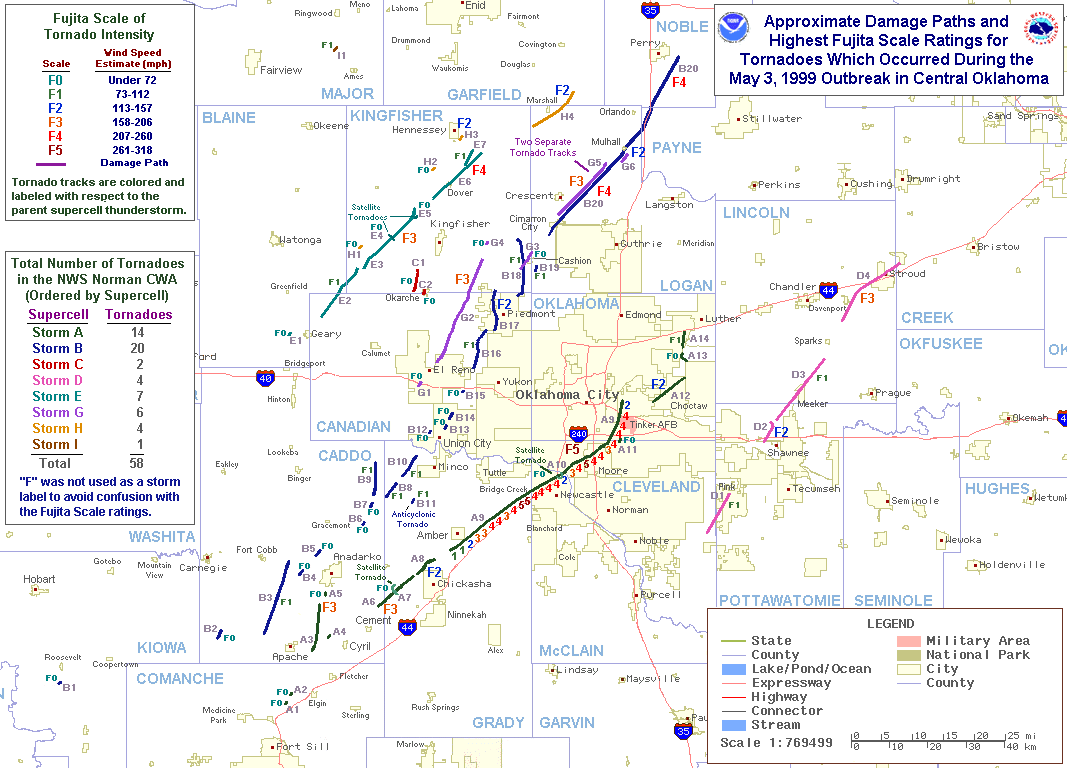
English: A map of the tornadoes occurring in the vicinity of Oklahoma City during the May 1999 Oklahoma tornado outbreak with F-Scale ratings. |
|||
| Date | ||||
| Source | http://www.srh.noaa.gov/images/oun/wxevents/19990503/maps/bigoutbreak.gif | |||
| Author | National Weather Service Norman, Oklahoma | |||
| Permission (Reusing this file) |
|
|||
| Other versions | The File:Tornado track map 1999 Oklahoma tornado outbreak.gif is an image incorporating Kansas tornadoes on top of the ones above reducing the resolution. |
Original upload log edit
| Date/Time | Dimensions | User | Comment |
|---|---|---|---|
| 30 May 2007, 04:12:11 | 1067 × 768 (63086 bytes) | Pierre cb (talk · contribs) | Tarcks of tornadoes of the May 3 and 4th 1999, Tornado Outbreak in Oklahoma. Producing in particular the F5 Oklahoma City monster. ~~~~ Source: [http://www.srh.noaa.gov/oun/storms/19990503/index.html NOAA] {{PD-USGov-NOAA}} [[Category:Tornadoes]] |
File history
Click on a date/time to view the file as it appeared at that time.
| Date/Time | Thumbnail | Dimensions | User | Comment | |
|---|---|---|---|---|---|
| current | 20:44, 19 July 2014 | | 1,067 × 768 (53 KB) | GifTagger (talk | contribs) | Bot: Converting file to superior PNG file. (Source: 1999-05-03_bigoutbreak.gif). This GIF was problematic due to non-greyscale color table. |
You cannot overwrite this file.
File usage on Commons
The following page uses this file:
- File:1999-05-03 bigoutbreak.gif (file redirect)
File usage on other wikis
The following other wikis use this file:
- Usage on de.wikipedia.org
- Usage on en.wikipedia.org
- Usage on fr.wikipedia.org